more stats
2,313 ft
Distance
172 ft
Climb
00:05:54
Avg time
172 ft
Altitude change
1,763 ft
Altitude min
1,936 ft
Altitude max
1,763 ft
Altitude start
1,936 ft
Altitude end
7.4%
Grade
1.3%
Grade max
19.6%
Grade min
2,313 ft
Distance climb
00:05:54
Avg time

Heaven Details

  • Activities
    • Mountain Bike
    • E-Bike
    • Winter Fat Bike
    • Hike
    • Trail Running
    • Snowshoe
  • Riding Area
    Buffalo Pound Provincial Park
    Moose Jaw, Saskatchewan
  • Difficulty Rating
  • Local Popularity
    100 in Mountain Biking [+]
    • 100 in E-Biking
    • 95 in Trail Running
    • 95 in Hiking
    • 90 in Snowshoeing
  • Global Ranking
    #25620 in Mountain Biking [+]
    • #3803 in E-Biking
    • #1717 in Trail Running
    • #89285 in Hiking
    • #813 in Snowshoeing
  • Trail Type
    Singletrack
  • Bike Type
    XC, Fat
  • Direction
    Both Directions
  • Climb Difficulty
    Blue
  • Physical Rating
    Moderate
  • eBike Allowed
  • Land Owner
    Saskatchewan Parks

Super mellow flow trail great for beginners but it's still fun for advanced riders. The trail has several rollers and bermed corners. The rollers can use as booters if you aren't ripping too fast. Getting air on them while going fast doesn't work well. The trail is a popular intermediate climb so when descending remember that there may be someone heading your way.

Access Info

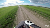
Travelling towards the end of the top service road, you can see the trail starting on the right hand side. Spring can be wet at the top flat section.

Local Trail Association

Recent Activity on Trail

Past Week
  • 1 rides
  • 7 miles average
6 Months
  • 53 rides
  • 14 miles avg distance
All
  • 859 rides
  • Last: Jul 4, 2026
c1c2c3c4
January
February
March
April
May
June
July
August
September
October
November
December
update trails status or condition

Heaven Trail Reports

Status:
on Aug 22, 2025
Ideal
Avg: 4.31 (10 votes)
Your vote: 0

view (10,476)
close
3D
Trail Conditions
  • Unknown
  • Snow Groomed
  • Snow Packed
  • Snow Covered
  • Snow Cover Partial
  • Freeze/thaw Cycle
  • Icy
  • Prevalent Mud
  • Wet
  • Variable
  • Ideal
  • Dry
  • Very Dry
Trail Flow (Ridden Direction)
Trailforks scans users ridelogs to determine the most popular direction each trail is ridden. A good flowing trail network will have most trails flowing in a single direction according to their intension.
The colour categories are based on what percentage of riders are riding a trail in its intended direction.
  • > 96%
  • > 90%
  • > 80%
  • > 70%
  • > 50%
  • < 50%
  • bi-directional trail
  • no data
Trail Last Ridden
Trailforks scans ridelogs to determine the last time a trail was ridden.
  • < 2 days
  • < 1 week
  • < 2 weeks
  • < 1 month
  • < 6 months
  • > 6 months
Trail Ridden Direction
The intended direction a trail should be ridden.
  • Downhill Only
  • Downhill Primary
  • Both Directions
  • Uphill Primary
  • Uphill Only
  • One Direction
Contribute Details
Colors indicate trail is missing specified detail.
  • Description
  • Photos
  • Description & Photos
  • Videos
Trail Popularity ?
Trailforks scans ridelogs to determine which trails are ridden the most in the last 9 months. Trails are compared with nearby trails in the same city region with a possible 25 colour shades. Think of this as a heatmap, more rides = more kinetic energy = warmer colors.
  • most popular
  • popular
  • less popular
  • not popular
ATV/ORV/OHV Filter
Max Vehicle Width
inches
US Cell Coverage
Legend
cell carrier legend

Radar Time
Activity Recordings
Trailforks uses anonymized public activity data. ?
Activity Recordings
Trailforks uses anonymized public activity data. ?
Personal Heatmap
Activity Types
all / none
Options
2
Date range month
Winter Trails
Warning A routing network for winter maps does not exist. Selecting trails using the winter trails layer has been disabled.
Missing Trails
Most Popular
Least Popular
Trails are colored based on popularity. The more popular a trail is, the more red. Less popular trails trend towards green.
Jump Magnitude Heatmap
Heatmap of where riders jump on trails. Zoom in to see individual jumps, click circles to view jump details.
BC Backroad Status

Service Road Atlas is a free to use, community-driven service for viewing and creating reports on the numerous back-country service roads around B.C. and Alberta.

map legend
Slope Aspect
Direction the slope faces
Flat N NE E SE S SW W NW
Trails Deemphasized
Trails are shown in grey.
disable
Only show trails with no bike usage.
Enable
Suggested Layers
Based on selected activity type

    Save the current map location and zoom level as your default home location whenever this page is loaded.

    Save
        Directions to heaven trailhead (50.575950, -105.398690)

        Photos

        13 more »
        168 |
        Jul 2, 2021 @ 12:42pm
        Jul 2, 2021
        213 |
        Jun 29, 2018 @ 9:05am
        Jun 29, 2018
        248 |
        Jul 23, 2017 @ 4:28pm
        Jul 23, 2017
        373 |
        Aug 24, 2016 @ 9:59pm
        Aug 24, 2016

        Videos

        3 more »
        Heaven
        0:47 | 346 | Jun 6, 2022 , Moose Jaw
        Heavan Trail | Buffalo Pound
        4:25 | 412 | Jun 28, 2018 , Moose Jaw
        Andrew Richard's Triumph of the Will
        8:29 | 658 | Nov 13, 2013 , Moose Jaw

        Routes with this trail

        5.0 16 miles 1,801 ft 30
        Potential 25kM endurance loop for the 2017 Prairie Summit Run-It
        12 miles 1,838 ft 19 Loop
        This 2 hour route links virtually all of the trails in the core area.
        12 miles 1,808 ft 53 Loop
        This combination of trails takes in all of the core area from the trail head, plus by going back out on it...

        2 Reviews & Comments


        We hope you've been enjoying Trailforks!

        Create a FREE account to view trail comments and much more.

        • By robwalcerTF Pro MJP MJP & contributors
        • #15543 - 4,994 views

        Frequently Asked Questions About Heaven

        Where is Heaven located?
        Heaven is located in Buffalo Pound Provincial Park, Moose Jaw, Saskatchewan, Canada. It is part of the Buffalo Pound Provincial Park trail network. The trailhead is located at coordinates 50.57595, -105.39869.
        How hard is Heaven?
        Heaven is rated as Blue difficulty. The physical rating is Moderate. The average grade is 7.4%. The climb difficulty is rated Blue.
        What is the elevation gain for Heaven?
        Heaven has 53 m of elevation gain. The elevation ranges from 538 m to 590 m.
        Is Heaven a point to point trail?
        Heaven is not a point to point trail. The direction is Both Directions. The trail type is singletrack.

        Hit the Trail

        Open in App

        Get this trail on your phone instantly.
        open trail in app

        Download Trail

        Save to wishlist, Garmin & download.
        save the trail

        Find Related Routes

        Find routes and users activities that include this trail.
        find routes for this trail

        You must enter a description before submitting.