more stats
1,565 ft
Distance
-340 ft
Descent
00:05:10
Avg time
-340 ft
Altitude change
2,580 ft
Altitude min
2,920 ft
Altitude max
2,920 ft
Altitude start
2,579 ft
Altitude end
-21.7%
Grade
-45.6%
Grade max
-8.9%
Grade min
1,565 ft
Distance down
00:05:10
Avg time

Heavy Flow Details

  • Activities
    • Mountain Bike
    • Hike
    • Trail Running
  • Riding Area
    Whistler South CRA
    Whistler, British Columbia
  • Difficulty Rating
  • Local Popularity
    70 in Mountain Biking [+]
    • 45 in Trail Running
    • 45 in Hiking
  • Global Ranking
    #37887 in Mountain Biking [+]
    • #105451 in Trail Running
    • #89502 in Hiking
  • Trail Type
    Singletrack
  • Bike Type
    AM
  • Direction
    Downhill Only
    Popular Direction Shown
  • Physical Rating
    Hard
  • Season
    Apr-Nov
  • Dogs Allowed
    Yes
  • TTFs on Trail
    Drop, Jump, Gap Jump, Rock Face
  • Ride in Rain
    Yes

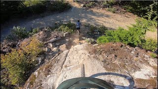
A very fun, relatively short, loamy trail which has flowy sections as well as steep and challenging sections with tight corners. Always a fun trail to link up into Hind Sight. Worth the climb and a good trail in most conditions.

Access Info

It's right next to the big electrical building off of the microwave road.

This trail is unsanctioned.

Recent Activity on Trail

Past Week
  • 4 rides
  • 7 miles average
6 Months
  • 29 rides
  • 8 miles avg distance
All
  • 475 rides
  • Last: Jun 30, 2022
c1c2c3c4
January
February
March
April
May
June
July
August
September
October
November
December
Status:
on Jun 16, 2026
Ideal
Avg: 4.55 (23 votes)
Your vote: 0

view (3,600)
close
3D
Trail Conditions
  • Unknown
  • Snow Groomed
  • Snow Packed
  • Snow Covered
  • Snow Cover Partial
  • Freeze/thaw Cycle
  • Icy
  • Prevalent Mud
  • Wet
  • Variable
  • Ideal
  • Dry
  • Very Dry
Trail Flow (Ridden Direction)
Trailforks scans users ridelogs to determine the most popular direction each trail is ridden. A good flowing trail network will have most trails flowing in a single direction according to their intension.
The colour categories are based on what percentage of riders are riding a trail in its intended direction.
  • > 96%
  • > 90%
  • > 80%
  • > 70%
  • > 50%
  • < 50%
  • bi-directional trail
  • no data
Trail Last Ridden
Trailforks scans ridelogs to determine the last time a trail was ridden.
  • < 2 days
  • < 1 week
  • < 2 weeks
  • < 1 month
  • < 6 months
  • > 6 months
Trail Ridden Direction
The intended direction a trail should be ridden.
  • Downhill Only
  • Downhill Primary
  • Both Directions
  • Uphill Primary
  • Uphill Only
  • One Direction
Contribute Details
Colors indicate trail is missing specified detail.
  • Description
  • Photos
  • Description & Photos
  • Videos
Trail Popularity ?
Trailforks scans ridelogs to determine which trails are ridden the most in the last 9 months. Trails are compared with nearby trails in the same city region with a possible 25 colour shades. Think of this as a heatmap, more rides = more kinetic energy = warmer colors.
  • most popular
  • popular
  • less popular
  • not popular
ATV/ORV/OHV Filter
Max Vehicle Width
inches
US Cell Coverage
Legend
cell carrier legend

Radar Time
Activity Recordings
Trailforks uses anonymized public activity data. ?
Activity Recordings
Trailforks uses anonymized public activity data. ?
Personal Heatmap
Activity Types
all / none
Options
2
Date range month
Winter Trails
Warning A routing network for winter maps does not exist. Selecting trails using the winter trails layer has been disabled.
Missing Trails
Most Popular
Least Popular
Trails are colored based on popularity. The more popular a trail is, the more red. Less popular trails trend towards green.
Jump Magnitude Heatmap
Heatmap of where riders jump on trails. Zoom in to see individual jumps, click circles to view jump details.
BC Backroad Status

Service Road Atlas is a free to use, community-driven service for viewing and creating reports on the numerous back-country service roads around B.C. and Alberta.

map legend
Slope Aspect
Direction the slope faces
Flat N NE E SE S SW W NW
Trails Deemphasized
Trails are shown in grey.
disable
Only show trails with no bike usage.
Enable
Suggested Layers
Based on selected activity type

    Save the current map location and zoom level as your default home location whenever this page is loaded.

    Save
        Directions to heavy-flow trailhead (50.078660, -123.014290)

        Photos

        68 more »
        396 |
        Aug 15, 2018 @ 11:04am
        Aug 15, 2018
        629 |
        Aug 14, 2018 @ 4:18pm
        Aug 14, 2018
        115 |
        Aug 20, 2022 @ 11:01pm
        Aug 20, 2022
        170 |
        Aug 20, 2022 @ 11:00pm
        Aug 20, 2022

        Videos

        10 more »
        youtuber Heavy Flow & Hind Sight - Whistler...
        5:34 | 550 | Jul 16, 2022 , Whistler
        youtuber HEAVY FLOW | Black trail | Cheakamus - Whistler
        3:35 | 241 | Nov 26, 2023 , Whistler
        youtuber Hey Bud - Whistler Mountain Biking - Sea to Sky
        9:37 | 860 | Jul 11, 2022 , Whistler
        Heavy Flow - Whistler, BC - MTB Trail Preview
        2:07 | 109 | Feb 8, 2025 , Whistler

        Trail Lists

        Routes with this trail

        3 miles 711 ft 2 Loop
        WORCA Virtual Toonie THILLER Sept 2-7, 2024 Collect your badge to earn your Apres deal and raffle entry...
        4 miles 816 ft 3
        Get out for a virtual ride this week Try a new trail, rediscover an old favourite, and stay connected to...
        3 miles 726 ft 2 Loop
        WORCA Virtual Toonie THRILLER Sept 4-9 2023

        Trail Products

        8 Reviews & Comments


        We hope you've been enjoying Trailforks!

        Create a FREE account to view trail comments and much more.

        • #27783 - 16,315 views

        Frequently Asked Questions About Heavy Flow

        Where is Heavy Flow located?
        Heavy Flow is located in Whistler South CRA, Whistler, British Columbia, Canada. It is part of the Whistler South CRA trail network. The trailhead is located at coordinates 50.07866, -123.01429.
        How hard is Heavy Flow?
        Heavy Flow is rated as Black Diamond difficulty. The physical rating is Hard. The average grade is 21.7%.
        What is the elevation gain for Heavy Flow?
        The trail has 104 m of elevation descent. The elevation ranges from 786 m to 890 m.
        Is Heavy Flow a point to point trail?
        Yes, Heavy Flow is a point to point trail. The direction is Downhill Only. The trail type is singletrack.

        Hit the Trail

        Open in App

        Get this trail on your phone instantly.
        open trail in app

        Download Trail

        Save to wishlist, Garmin & download.
        save the trail

        Find Related Routes

        Find routes and users activities that include this trail.
        find routes for this trail

        You must enter a description before submitting.