7 miles
Distance
727 ft
Climb
-727 ft
Descent
00:51:42
Avg time
Herzel Details
-
Activities
- Mountain Bike
- E-Bike
- Hike
- Trail Running
-
Riding Area
-
AKAהרצל
-
Difficulty Rating
-
Trail TypeSingletrack
-
Bike TypeAM, XC
-
Trail UsageBiking Primary
-
DirectionOne Direction
-
Physical RatingEasy
-
SeasonWhenever it's dry
-
Dogs AllowedYes
-
eBike Allowed
-
Global Ranking#13757 in Mountain Biking
-
Local Popularity60 in Mountain Biking [+]
- 60 in E-Biking
- 60 in Trail Running
- 60 in Hiking
-
Land ManagerKKL
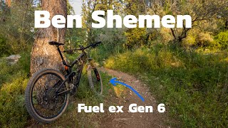
The most Popular trail in Ben Shemen, all marked White-Blue-White. riding direction is CCW, It's a round trip but you can combine sections with other trails in the forest. on weekend it is very busy
More Stats for Herzel mountain bike trail trail
-
Altitude change0 ft
-
Altitude min326 ft
-
Altitude max559 ft
-
Altitude start343 ft
-
Altitude end343 ft
-
Grade0.001%
-
Grade max-49.346%
-
Grade min34.092%
-
Distance climb3 miles
-
Distance down2 miles
-
Distance flat2 miles
-
Avg time00:51:42
-
Avg reverse time01:05:26
- view trail stats
close
Trail Conditions
- Unknown
- Snow Groomed
- Snow Packed
- Snow Covered
- Freeze/thaw Cycle
- Icy
- Prevalent Mud
- Wet
- Variable
- Ideal
- Dry
- Very Dry
Trail Ridden Direction
Trailforks scans users ridelogs to determine the most popular direction each trail is ridden. A good flowing trail network will have most trails flowing in a single direction according to their intension.
The colour categories are based on what percentage of riders are riding a trail in its intended direction.
- > 96%
- > 90%
- > 80%
- > 70%
- > 50%
- < 50%
Trail Last Ridden
Trailforks scans ridelogs to determine the last time a trail was ridden.
- < 2 days
- < 1 week
- < 2 weeks
- < 1 month
- < 6 months
- > 6 months
Trail Ridden Direction
The intended direction a trail should be ridden.
- Downhill Only
- Downhill Primary
- Both Directions
- Uphill Primary
- Uphill Only
- One Direction
ContributeDetails
Colors indicate trail is missing specified detail.
- Description
- Photos
- Description & Photos
- Videos
Trail Popularity ?
Trailforks scans ridelogs to determine which trails are ridden the most in the last 9 months.
Trails are compared with nearby trails in the same city region with a possible 25 colour shades.
Think of this as a heatmap, more rides = more kinetic energy = warmer colors.
- most popular
- popular
- less popular
- not popular
ATV/ORV/OHV Filter
Max Vehicle Width
inches
Radar Time
LEGEND
Trail Difficulties
Trail Report Status
- Access Road/Trail
- White
- Green
- Blue
- Black
- Double Black Diamond
Trail Report Status
- Clear / Green
- Minor Issue / Yellow
- Significant Issue / Amber
- Closed
- Land Owner Overlay
- Wilderness (typically no bikes in USA)
- BLM (public)
- USFS (Wildlife sanctuaries darker than usfs)
- State land
- Indigenous
- Military
Trail Conditions
- Unknown
- Snow Groomed
- Snow Packed
- Snow Covered
- Freeze/thaw Cycle
- Icy
- Prevalent Mud
- Wet
- Variable
- Ideal
- Dry
- Very Dry
- Map Markers
Trail Head
Photo
Directory Listing
Riding Area
TTF
Parking
Viewpoint
Information
Warning
Directions
Sight
Restrooms
eBike Charging Point
Water Fountain/Source
Gate
Trail Sign
Table or Bench
Ladder
Stairs
Bridge
Boardwalk
Camping
Cabin
Lodge
Bear Cache
Dock
Ranger Station
Summit
Other
Directions to herzel trailhead
(31.940540, 34.949250)
update trails status or condition
Herzel Trail Reports
view all reports »
Recent Ridelog Activity on Trail
Past Week
- 2 rides
- 24 miles avg distance
6 Months
- 35 rides
- 21 miles avg distance
All
- 950 rides
Photos
more »
Trail Lists
-
KKL singletracks13 trails
Trail Products
Reviews / Comments
No reviews yet, be the first to write a review or ask a question.
Use trail reports to comment on trail conditions.
Nearby Trails
- Anava Singletrack 1,115 ft
- Bumps 3,701 ft
- The Fork 4,068 ft
- Rotten Goat 1 mile
- Kawabanga 1 mile
- embed Herzel trail on your website
- By ziv-bikeaway
TRAILFORKS & contributors
- #19871 - 3,071 views
- subscribe
- login to download gpx or kml files.
Open trail in mobile app