more stats
1.1 miles
Distance
89 ft
Climb
-128 ft
Descent
00:07:53
Avg time
-38 ft
Altitude change
527 ft
Altitude min
600 ft
Altitude max
568 ft
Altitude start
531 ft
Altitude end
-0.7%
Grade
-16%
Grade max
16.1%
Grade min
2,096 ft
Distance climb
2,477 ft
Distance down
1,010 ft
Distance flat
00:07:53
Avg time

High Gravity Details

  • Activities
    • Mountain Bike
    • E-Bike
    • Winter Fat Bike
    • Hike
    • Trail Running
  • Riding Area
    Chewacla State Park
    Auburn, Alabama
  • Difficulty Rating
  • Local Popularity
    95 in Mountain Biking [+]
    • 95 in E-Biking
    • 60 in Trail Running
    • 75 in Hiking
  • Global Ranking
    #5520 in Mountain Biking [+]
    • #43088 in Trail Running
    • #48218 in Hiking
  • Trail Type
    Singletrack
  • Bike Type
    AM, XC, Fat
  • Direction
    Downhill Primary
    Popular Direction Shown
  • Dogs Allowed
    Yes
  • eBike Allowed
  • TTFs on Trail
    Drop, Jump, Roller Coaster
  • Land Owner
    Alabama State Parks

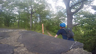
High Gravity Trail leaves from behind the Upper Pavilion and connects to the beginning of Tiger Woods. A brief rolling section leads to the Quarry Overlook. From here the fun begins Look for numerous dirt, wood, and rock features along the course of this trail. While the main trail is of an intermediate difficulty, choosing to ride the options ups the difficulty significantly. The trail has three downhill segments, each with their own unique flair, separated by short easy climbs.

Local Trail Association
Traditionally Indigenous Territory

Recent Activity on Trail

Past Week
  • 5 rides
  • 10 miles average
6 Months
  • 62 rides
  • 15 miles avg distance
All
  • 328 rides
  • Last: Jul 2, 2026
c1c2c3c4
January
February
March
April
May
June
July
August
September
October
November
December
Status:
on Mar 3, 2026
Very Dry
Avg: 4.38 (12 votes)
Your vote: 0

view (5,320)
close
3D
Trail Conditions
  • Unknown
  • Snow Groomed
  • Snow Packed
  • Snow Covered
  • Snow Cover Partial
  • Freeze/thaw Cycle
  • Icy
  • Prevalent Mud
  • Wet
  • Variable
  • Ideal
  • Dry
  • Very Dry
Trail Flow (Ridden Direction)
Trailforks scans users ridelogs to determine the most popular direction each trail is ridden. A good flowing trail network will have most trails flowing in a single direction according to their intension.
The colour categories are based on what percentage of riders are riding a trail in its intended direction.
  • > 96%
  • > 90%
  • > 80%
  • > 70%
  • > 50%
  • < 50%
  • bi-directional trail
  • no data
Trail Last Ridden
Trailforks scans ridelogs to determine the last time a trail was ridden.
  • < 2 days
  • < 1 week
  • < 2 weeks
  • < 1 month
  • < 6 months
  • > 6 months
Trail Ridden Direction
The intended direction a trail should be ridden.
  • Downhill Only
  • Downhill Primary
  • Both Directions
  • Uphill Primary
  • Uphill Only
  • One Direction
Contribute Details
Colors indicate trail is missing specified detail.
  • Description
  • Photos
  • Description & Photos
  • Videos
Trail Popularity ?
Trailforks scans ridelogs to determine which trails are ridden the most in the last 9 months. Trails are compared with nearby trails in the same city region with a possible 25 colour shades. Think of this as a heatmap, more rides = more kinetic energy = warmer colors.
  • most popular
  • popular
  • less popular
  • not popular
ATV/ORV/OHV Filter
Max Vehicle Width
inches
US Cell Coverage
Legend
cell carrier legend

Radar Time
Activity Recordings
Trailforks uses anonymized public activity data. ?
Activity Recordings
Trailforks uses anonymized public activity data. ?
Personal Heatmap
Activity Types
all / none
Options
2
Date range month
Winter Trails
Warning A routing network for winter maps does not exist. Selecting trails using the winter trails layer has been disabled.
Missing Trails
Most Popular
Least Popular
Trails are colored based on popularity. The more popular a trail is, the more red. Less popular trails trend towards green.
Jump Magnitude Heatmap
Heatmap of where riders jump on trails. Zoom in to see individual jumps, click circles to view jump details.
BC Backroad Status

Service Road Atlas is a free to use, community-driven service for viewing and creating reports on the numerous back-country service roads around B.C. and Alberta.

map legend
Slope Aspect
Direction the slope faces
Flat N NE E SE S SW W NW
Trails Deemphasized
Trails are shown in grey.
disable
Only show trails with no bike usage.
Enable
Suggested Layers
Based on selected activity type

    Save the current map location and zoom level as your default home location whenever this page is loaded.

    Save
        Directions to high-gravity trailhead (32.549790, -85.476350)

        Photos

        4 more »
        201 |
        Oct 13, 2017 @ 11:14am
        Oct 13, 2017
        245 |
        Oct 12, 2017 @ 12:04pm
        Oct 12, 2017
        248 |
        Oct 8, 2017 @ 11:51am
        Oct 8, 2017
        328 |
        May 22, 2017 @ 9:31pm
        May 22, 2017

        Videos

        1 more »
        Chewacla State Park
        0:31 | 398 | May 5, 2016 , Auburn

        Routes with this trail

        22 miles 1,434 ft 29 Loop
        chewacla everthing loop include most off green, blue and black routes.
        17 miles 1,354 ft 71
        A challenging route that highlights fun areas of Chewacla
        5 miles 612 ft 5 Loop Race
        Go Nuts Biking has 2 exciting XC/Cross Country USA Cycling Regional Championship Series for 2024! Whether...

        Reviews / Comments

        No reviews yet, be the first to write a review or ask a question.
        Use trail reports to comment on trail conditions.


        We hope you've been enjoying Trailforks!

        Create a FREE account to view trail comments and much more.

        • By PhiliciousnessTF Pro SORBA & contributors
        • #31627 - 2,719 views

        Frequently Asked Questions About High Gravity

        Where is High Gravity located?
        High Gravity is located in Chewacla State Park, Auburn, Alabama, United States. It is part of the Chewacla State Park trail network. The trailhead is located at coordinates 32.54979, -85.47635.
        How hard is High Gravity?
        High Gravity is rated as Blue difficulty. The average grade is 0.7%.
        What is the elevation gain for High Gravity?
        High Gravity has 89 ft of elevation gain. The trail has 128 ft of elevation descent. The elevation ranges from 527 ft to 600 ft.
        Is High Gravity a point to point trail?
        High Gravity is not a point to point trail. The direction is Downhill Primary. The trail type is singletrack.

        Hit the Trail

        Open in App

        Get this trail on your phone instantly.
        open trail in app

        Download Trail

        Save to wishlist, Garmin & download.
        save the trail

        Find Related Routes

        Find routes and users activities that include this trail.
        find routes for this trail

        You must enter a description before submitting.