
more stats
2.2 miles
Distance
558 ft
Climb
-279 ft
Descent
00:36:40
Avg time
279 ft
Altitude change
7,982 ft
Altitude min
8,503 ft
Altitude max
7,982 ft
Altitude start
8,261 ft
Altitude end
2.5%
Grade
-30.2%
Grade max
28.5%
Grade min
1 mile
Distance climb
3,520 ft
Distance down
1,348 ft
Distance flat
00:36:40
Avg time

High Roller Details

  • Activities
    • Mountain Bike
    • Hike
    • Trail Running
  • Riding Area
    Cave Lake State Park
    Ely, Nevada
  • Difficulty Rating
  • Local Popularity
    75 in Mountain Biking heatmap [+]
    • 95 in Trail Running
    • 95 in Hiking
  • Global Ranking
    #86414 in Mountain Biking [+]
    • #92764 in Trail Running
    • #99549 in Hiking
  • State Ranking
    #465 in Mountain Biking · Nevada [+]
    • #483 in Trail Running
    • #464 in Hiking
  • Trail Type
    Singletrack
  • Direction
    Both Directions
  • Dogs Allowed
    Yes
  • eBike Allowed

The views on this trail will be well worth the climb. It is used both clockwise and counter clockwise, however the climbing is easiest counter clockwise, but the descent is the most fun going clockwise. for this reason, some locals us this trail as an out and back.

Tags
Picnic spot

Trail Supporters

Local Trail Association

Traditionally Indigenous Territory

Recent Activity on Trail

Past Week
  • 0 rides
  •  
6 Months
  • 10 rides
  • 11 miles avg distance
All
  • 72 rides
  • Last: Oct 14, 2026
Status:
on Nov 4, 2026
Avg: 4.24 (6 votes)
Your vote: 0

view (315)
close
      Directions to high-roller-83506 trailhead (39.173430, -114.696990)

      Photos

      18 more »
      mtb
      53 |
      Jul 2, 2026 @ 11:23am
      Jul 2, 2026
      mtb
      53 |
      Jul 2, 2026 @ 11:21am
      Jul 2, 2026
      mtb
      187 |
      May 5, 2022 @ 4:55pm
      May 5, 2022
      mtb
      136 |
      May 5, 2022 @ 4:53pm
      May 5, 2022

      Videos

      1 more »
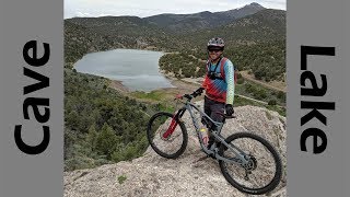
      Views & Flow for Days! Mountain Biking...
      mtb
      16:04 | 474 | Jun 26, 2019 , Ely

      Routes with this trail

      more »
      ★ 5.0 • 10 miles • 1,592 ft • 4 •
      Start at Steptoe Creek Trailhead and ride the route clockwise for best results, but can be ridden in...
      ★ 1.0 • 11 miles • 1,575 ft • 4 •
      A full tour of the Cave Lake area. There's some steep climbing, fast descents, awesome views, and a little...
      4.5 ★★★★★
      6 Ratings
      5 ★ 67%
      4 ★ 17%
      3 ★ 17%
      2 ★
      1 ★

      3 Reviews & Comments

      BasedGawd BasedGawd
      One of my fav trails in Nevada. Borders on high alpine, cuts through some rare NV forest, and ends with some fun desert-ish tech. Great mix of smooth and fast and tech. On the challenging end of blue if ridden aggressively.
      2tall2old 2tall2old
      Made this the top of the lollipop with Twisted Pines being the stem. Rode counterclockwise. Super fun trail though the Overlook Connector to get to the top fairly steep with switchbacks. There is one tree down across trail about 150 yards from the top as you drop in.
      mjllang
      Super fun and super well-built trail with insanely good scenery- if you can stop to take a look around. Suggest Overlook-Cutiff-High Roller-Twisted Pines. Really an amazing ride. Ely has some stuff.....Smile

      We hope you've been enjoying Trailforks!

      Create a FREE account to view all trail reviews and much more.

      • By toddTF Pro Trailforks & contributors
      • #83506 - 2,256 views

      Frequently Asked Questions

      ▼ Where is High Roller located?
      High Roller is located in Cave Lake State Park, Ely, Nevada, United States. It is part of the Cave Lake State Park trail network. The trailhead is located at coordinates 39.17343, -114.69699.
      ▼ How hard is High Roller?
      High Roller is rated as Blue difficulty. The average grade is 2.5%.
      ▼ What is the elevation gain for High Roller?
      High Roller has 558 ft of elevation gain. The trail has 279 ft of elevation descent. The elevation ranges from 7,982 ft to 8,503 ft.
      ▼ Is High Roller a point to point trail?
      High Roller is not a point to point trail. The direction is Both Directions. The trail type is singletrack.
      ▼ How long is High Roller?
      High Roller is 2.2 miles long. The trail type is singletrack.
      ▼ Are dogs allowed on High Roller?
      Yes, dogs are allowed on High Roller. Please keep dogs on a leash where required and clean up after them.
      ▼ How do I access High Roller? Where is the closest parking trailhead?
      The closest parking and trailhead locations to High Roller are: View all parking locations in the area.
      ▼ How long does it take to ride High Roller?
      Based on recorded activities, it takes an average of 37 minutes to ride High Roller. The trail is 2.2 miles long. Actual times will vary based on fitness level, conditions, and pace. View recent activity logs for more details.
      ▼ How busy is High Roller?
      High Roller is a very popular trail. There have been 302 recorded activities on this trail. The trail has received 315 check-ins. View recent activity on this trail.

      Hit the Trail

      Open in App

      Get this trail on your phone instantly.

      open trail in app

      Download Trail

      Save to wishlist, Garmin & download.
      save the trail

      Find Related Routes

      Find routes and users activities that include this trail.
      find routes for this trail

      You must enter a description before submitting.