


Open in App
Get this trail on your phone instantly.

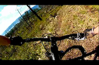
Yeehaw, grab your shotguns and banjos and go for rip. This trail has a little bit of everything. Steeper and loose, faster and flowy, some flat pedally transfer sections, the occasional berm and tech section. Classic Crawford feel with lots of rock and fantastic views of the Okanagan Valley.
| c1 | c2 | c3 | c4 |
|---|---|---|---|
January | February | March | April |
May | June | July | August |
September | October | November | December |

Service Road Atlas is a free to use, community-driven service for viewing and creating reports on the numerous back-country service roads around B.C. and Alberta.
Save the current map location and zoom level as your default home location whenever this page is loaded.
SaveWe hope you've been enjoying Trailforks!
Create a FREE account to view trail comments and much more.
You must enter a description before submitting.

