2.4 miles
Distance
79 ft
Climb
-1,369 ft
Descent
00:16:35
Avg time

Högtrail Details

  • Activities
    • Mountain Bike
  • Riding Area
    Bike Serfaus-Fiss-Ladis
    Serfaus-Fiss-Ladis
  • Ref Number
    #7081
  • Difficulty Rating
  • Voted Difficulty
    Green (2 votes)
  • Trail Type
    Singletrack
  • Bike Type
    DH, AM, XC
  • Direction
    Downhill Only
    Popular direction shown
  • Physical Rating
    Moderate
  • Trail Visibility
    Always easy to follow
  • Alpine Trail
    Yes
  • TTFs on Trail
    Bridge, Rock Garden
  • Global Ranking
    #17238 in Mountain Biking
  • Local Popularity
    65 in Mountain Biking
  • Year Opened
    2018
  • Land Owner

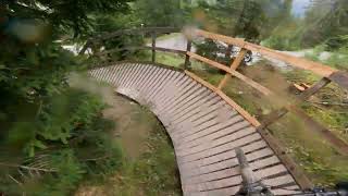
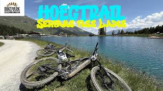
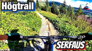
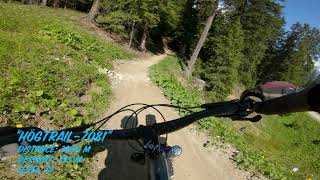
Want to delve into the world of mountain biking? Or just experience pure mountain bike track pleasure in a more laid-back way? The Högtrail makes it possible. A “simple” track (blue), which nevertheless has a lot to offer.

source: ...
Access Info

The Högtrail starts at the Högsee, at 1.829 m, and can be reached directly from the middle station of the Alpkopfbahn in Hög.

Bike Park

More Stats for Högtrail mountain bike trail trail
  • Altitude change
    -1,290 ft
  • Altitude min
    4,720 ft
  • Altitude max
    6,010 ft
  • Altitude start
    6,010 ft
  • Altitude end
    4,721 ft
  • Grade
    -10%
  • Grade max
    -78.3%
  • Grade min
    19.1%
  • Distance climb
    1,493 ft
  • Distance down
    2 miles
  • Distance flat
    1,808 ft
  • Avg time
    00:16:35
  • view trail stats
Status:
on Jul 17, 2024
Variable
Avg: 4.24 (10 votes)
Your vote: 0

view (1,275)
close
3D
Trail Conditions
  • Unknown
  • Snow Groomed
  • Snow Packed
  • Snow Covered
  • Snow Cover Partial
  • Freeze/thaw Cycle
  • Icy
  • Prevalent Mud
  • Wet
  • Variable
  • Ideal
  • Dry
  • Very Dry
Trail Flow (Ridden Direction)
Trailforks scans users ridelogs to determine the most popular direction each trail is ridden. A good flowing trail network will have most trails flowing in a single direction according to their intension.
The colour categories are based on what percentage of riders are riding a trail in its intended direction.
  • > 96%
  • > 90%
  • > 80%
  • > 70%
  • > 50%
  • < 50%
  • bi-directional trail
  • no data
Trail Last Ridden
Trailforks scans ridelogs to determine the last time a trail was ridden.
  • < 2 days
  • < 1 week
  • < 2 weeks
  • < 1 month
  • < 6 months
  • > 6 months
Trail Ridden Direction
The intended direction a trail should be ridden.
  • Downhill Only
  • Downhill Primary
  • Both Directions
  • Uphill Primary
  • Uphill Only
  • One Direction
Contribute Details
Colors indicate trail is missing specified detail.
  • Description
  • Photos
  • Description & Photos
  • Videos
Trail Popularity ?
Trailforks scans ridelogs to determine which trails are ridden the most in the last 9 months. Trails are compared with nearby trails in the same city region with a possible 25 colour shades. Think of this as a heatmap, more rides = more kinetic energy = warmer colors.
  • most popular
  • popular
  • less popular
  • not popular
ATV/ORV/OHV Filter
Max Vehicle Width
inches
US Cell Coverage
Legend
cell carrier legend

Radar Time
x Activity Recordings
Trailforks users anonymized public ridelogs from the past 6 months.
  • mountain biking recent
  • mountain biking (>6 month)
  • hiking (1 year)
  • moto (1 year)
Activity Recordings
Trailforks users anonymized public skilogs from the past 12 months.
  • Downhill Ski
  • Backcountry Ski
  • Nordic Ski
  • Snowmobile
Winter Trails
Warning A routing network for winter maps does not exist. Selecting trails using the winter trails layer has been disabled.
x Missing Trails
Most Popular
Least Popular
Trails are colored based on popularity. The more popular a trail is, the more red. Less popular trails trend towards green.
Jump Magnitude Heatmap
Heatmap of where riders jump on trails. Zoom in to see individual jumps, click circles to view jump details.
Trails Deemphasized
Trails are shown in grey.
disable
Only show trails with NO bikes.
enable

Save the current map location and zoom level as your default home location whenever this page is loaded.

Save
      Directions to hogtrail trailhead (47.037350, 10.579250)
      update trails status or condition

      Högtrail Trail Reports

      Recent Ridelog Activity on Trail

      Past Week
      • 0 rides
      •  
      6 Months
      • 0 rides
      •  
      All
      • 180 rides
      • Last: Jul 19, 2020

      Photos

      more »
      143 |
      Sep 18, 2020 @ 2:43am
      Sep 18, 2020
      52 |
      Aug 21, 2021 @ 12:55pm
      Aug 21, 2021
      50 |
      Aug 9, 2021 @ 7:32am
      Aug 9, 2021
      50 |
      Aug 9, 2021 @ 7:32am
      Aug 9, 2021

      2 Reviews & Comments


      We hope you've been enjoying Trailforks!

      Create a FREE account to view trail comments and much more.

      Videos

      more »
      youtuber Högtrail #7081 - Bike Park Serfaus-Fiss-Ladis
      10:15 | 160 | Sep 7, 2023 , Serfaus-Fiss-Ladis
      Högtrail #7081 in Serfaus top to bottom raw
      9:38 | 203 | Nov 6, 2021 , Serfaus-Fiss-Ladis
      • By MaaxsTF Pro & contributors
      • #196539 - 1,514 views

      You must enter a description before submitting.