more stats
299 ft
Distance
2 ft
Climb
-30 ft
Descent
00:00:45
Avg time
-27 ft
Altitude change
4,397 ft
Altitude min
4,427 ft
Altitude max
4,425 ft
Altitude start
4,396 ft
Altitude end
-9.1%
Grade
-18.3%
Grade max
3.5%
Grade min
69 ft
Distance climb
190 ft
Distance down
39 ft
Distance flat
00:00:45
Avg time

In-Between Details

  • Activities
    • Mountain Bike
    • E-Bike
  • Riding Area
    Whistler Mountain Bike Park
    Whistler, British Columbia
  • Difficulty Rating
  • Voted Difficulty
    Double Black Diamond (1 vote)
  • Local Popularity
    15 in Mountain Biking [+]
    • 20 in E-Biking
  • Global Ranking
    #37221 in Mountain Biking [+]
    • #93240 in E-Biking
  • Trail Type
    Mixed
  • Bike Type
    DH
  • Direction
    Downhill Only
    Popular Direction Shown
  • TTFs on Trail
    Rock Face
  • Year Opened
    2023
  • Land Owner

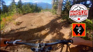
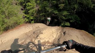
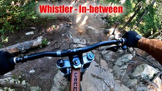
In-Between is a double black rated tech trail starting on 'Captain Safety' and cutting across to 'In-Deep'. This trail is steep and technical requiring expert skills to navigate. There are two rock features joined with steep sections of loose rocks and roots. Not advised in wet conditions.

Look at features, Pre ride, Re ride then Free ride.

Access Info

Access off Captain Safety, finishing on In-Deep

Bike Park

Recent Activity on Trail

Past Week
  • 10 rides
  • 31 miles average
6 Months
  • 10 rides
  • 31 miles avg distance
All
  • 84 rides
  • Last: Jun 19, 2026
c1c2c3c4
January
February
March
April
May
June
July
August
September
October
November
December
update trails status or condition

In-Between Trail Reports

statusdatedescription
Oct 18, 2025 @ 11:49pm (America/Vancouver)
Oct 18, 2025
Closed for the season, see you in 2026
Jun 15, 2025 @ 1:05pm
Jun 15, 2025
Opened for the season. WBPP.
Jun 8, 2025 @ 2:33pm
Jun 8, 2025
Trail closed. WBPP
May 23, 2025 @ 6:03pm
May 23, 2025
Oct 25, 2024 @ 5:20pm
Oct 25, 2024
Closed for 2024 Bike Park season
more »
Status:
on Oct 18, 2025
Avg: 4.45 (7 votes)
Your vote: 0

view (428)
close
3D
Trail Conditions
  • Unknown
  • Snow Groomed
  • Snow Packed
  • Snow Covered
  • Snow Cover Partial
  • Freeze/thaw Cycle
  • Icy
  • Prevalent Mud
  • Wet
  • Variable
  • Ideal
  • Dry
  • Very Dry
Trail Flow (Ridden Direction)
Trailforks scans users ridelogs to determine the most popular direction each trail is ridden. A good flowing trail network will have most trails flowing in a single direction according to their intension.
The colour categories are based on what percentage of riders are riding a trail in its intended direction.
  • > 96%
  • > 90%
  • > 80%
  • > 70%
  • > 50%
  • < 50%
  • bi-directional trail
  • no data
Trail Last Ridden
Trailforks scans ridelogs to determine the last time a trail was ridden.
  • < 2 days
  • < 1 week
  • < 2 weeks
  • < 1 month
  • < 6 months
  • > 6 months
Trail Ridden Direction
The intended direction a trail should be ridden.
  • Downhill Only
  • Downhill Primary
  • Both Directions
  • Uphill Primary
  • Uphill Only
  • One Direction
Contribute Details
Colors indicate trail is missing specified detail.
  • Description
  • Photos
  • Description & Photos
  • Videos
Trail Popularity ?
Trailforks scans ridelogs to determine which trails are ridden the most in the last 9 months. Trails are compared with nearby trails in the same city region with a possible 25 colour shades. Think of this as a heatmap, more rides = more kinetic energy = warmer colors.
  • most popular
  • popular
  • less popular
  • not popular
ATV/ORV/OHV Filter
Max Vehicle Width
inches
US Cell Coverage
Legend
cell carrier legend

Radar Time
Activity Recordings
Trailforks uses anonymized public activity data. ?
Activity Recordings
Trailforks uses anonymized public activity data. ?
Personal Heatmap
Activity Types
all / none
Options
2
Date range month
Winter Trails
Warning A routing network for winter maps does not exist. Selecting trails using the winter trails layer has been disabled.
Missing Trails
Most Popular
Least Popular
Trails are colored based on popularity. The more popular a trail is, the more red. Less popular trails trend towards green.
Jump Magnitude Heatmap
Heatmap of where riders jump on trails. Zoom in to see individual jumps, click circles to view jump details.
BC Backroad Status

Service Road Atlas is a free to use, community-driven service for viewing and creating reports on the numerous back-country service roads around B.C. and Alberta.

map legend
Slope Aspect
Direction the slope faces
Flat N NE E SE S SW W NW
Trails Deemphasized
Trails are shown in grey.
disable
Only show trails with no bike usage.
Enable
Suggested Layers
Based on selected activity type

    Save the current map location and zoom level as your default home location whenever this page is loaded.

    Save
        Directions to inbetween trailhead (50.088380, -122.958700)

        Photos

        No photos have been added for In-Between yet, add a photo.

        Videos

        4 more »
        youtuber Most INSANE Moments of 2023! (Pt. 4) -...
        8:19 | 168 | Jan 7, 2024 , Whistler
        youtuber Most INSANE Moments of 2023! (Pt. 2) - 'The...
        8:34 | 149 | Dec 16, 2023 , Whistler
        Gnarly Whistler Tech with the DirtGuru!
        13:52 | 108 | Nov 29, 2023 , Whistler
        Whistler - In Between - Guy's Trail...
        0:03 | 180 | Sep 16, 2023 , Whistler

        Reviews / Comments

        No reviews yet, be the first to write a review or ask a question.
        Use trail reports to comment on trail conditions.


        We hope you've been enjoying Trailforks!

        Create a FREE account to view trail comments and much more.

        • By Jakeraine66TF Pro WBPP & contributors
        • #682965 - 725 views

        Frequently Asked Questions About In-Between

        Where is In-Between located?
        In-Between is located in Whistler Mountain Bike Park, Whistler, British Columbia, Canada. It is part of the Whistler Mountain Bike Park trail network. The trailhead is located at coordinates 50.08838, -122.9587.
        How hard is In-Between?
        In-Between is rated as Double Black Diamond difficulty. The average grade is 9.1%.
        What is the elevation gain for In-Between?
        In-Between has 2 ft of elevation gain. The trail has 30 ft of elevation descent. The elevation ranges from 4,397 ft to 4,427 ft.
        Is In-Between a point to point trail?
        Yes, In-Between is a point to point trail. The direction is Downhill Only. The trail type is mixed.

        Hit the Trail

        Open in App

        Get this trail on your phone instantly.
        open trail in app

        Download Trail

        Save to wishlist, Garmin & download.
        save the trail

        Find Related Routes

        Find routes and users activities that include this trail.
        find routes for this trail

        You must enter a description before submitting.