more stats
1,129 ft
Distance
-152 ft
Descent
00:01:22
Avg time
-152 ft
Altitude change
608 ft
Altitude min
760 ft
Altitude max
760 ft
Altitude start
607 ft
Altitude end
-13.4%
Grade
-26.5%
Grade max
-4.2%
Grade min
1,129 ft
Distance down
00:01:22
Avg time

Indy Details

  • Activities
    • Mountain Bike
  • Riding Area
    Mountain Creek Resort
    Vernon, New Jersey
  • Difficulty Rating
  • Voted Difficulty
    Blue (1 vote)
  • Local Popularity
    95 in Mountain Biking
  • Global Ranking
    #2470 in Mountain Biking
  • Trail Type
    Machine Groomed
  • Bike Type
    DH, AM
  • Direction
    Downhill Only
  • Physical Rating
    Hard
  • Trail Visibility
    Always easy to follow
  • Alpine Trail
    Yes
  • TTFs on Trail
    Berm, Jump, Pump Track, Other

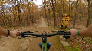
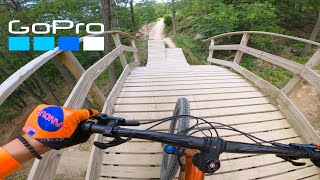
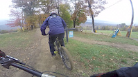
Short flow trail, lots of tight berms & a few tables.

Access Info

Access via Frog Pond, Crap Chute, & Greenhorn

Disclaimer

Always dry

Bike Park

Traditionally Indigenous Territory

Recent Activity on Trail

Past Week
  • 19 rides
  • 16 miles average
6 Months
  • 225 rides
  • 19 miles avg distance
All
  • 1,946 rides
  • Last: Jun 28, 2026
c1c2c3c4
January
February
March
April
May
June
July
August
September
October
November
December
Status:
on Jun 5, 2026
Dry
Avg: 3.92 (8 votes)
Your vote: 0

view (26,692)
close
3D
Trail Conditions
  • Unknown
  • Snow Groomed
  • Snow Packed
  • Snow Covered
  • Snow Cover Partial
  • Freeze/thaw Cycle
  • Icy
  • Prevalent Mud
  • Wet
  • Variable
  • Ideal
  • Dry
  • Very Dry
Trail Flow (Ridden Direction)
Trailforks scans users ridelogs to determine the most popular direction each trail is ridden. A good flowing trail network will have most trails flowing in a single direction according to their intension.
The colour categories are based on what percentage of riders are riding a trail in its intended direction.
  • > 96%
  • > 90%
  • > 80%
  • > 70%
  • > 50%
  • < 50%
  • bi-directional trail
  • no data
Trail Last Ridden
Trailforks scans ridelogs to determine the last time a trail was ridden.
  • < 2 days
  • < 1 week
  • < 2 weeks
  • < 1 month
  • < 6 months
  • > 6 months
Trail Ridden Direction
The intended direction a trail should be ridden.
  • Downhill Only
  • Downhill Primary
  • Both Directions
  • Uphill Primary
  • Uphill Only
  • One Direction
Contribute Details
Colors indicate trail is missing specified detail.
  • Description
  • Photos
  • Description & Photos
  • Videos
Trail Popularity ?
Trailforks scans ridelogs to determine which trails are ridden the most in the last 9 months. Trails are compared with nearby trails in the same city region with a possible 25 colour shades. Think of this as a heatmap, more rides = more kinetic energy = warmer colors.
  • most popular
  • popular
  • less popular
  • not popular
ATV/ORV/OHV Filter
Max Vehicle Width
inches
US Cell Coverage
Legend
cell carrier legend

Radar Time
Activity Recordings
Trailforks uses anonymized public activity data. ?
Activity Recordings
Trailforks uses anonymized public activity data. ?
Personal Heatmap
Activity Types
all / none
Options
2
Date range month
Winter Trails
Warning A routing network for winter maps does not exist. Selecting trails using the winter trails layer has been disabled.
Missing Trails
Most Popular
Least Popular
Trails are colored based on popularity. The more popular a trail is, the more red. Less popular trails trend towards green.
Jump Magnitude Heatmap
Heatmap of where riders jump on trails. Zoom in to see individual jumps, click circles to view jump details.
BC Backroad Status

Service Road Atlas is a free to use, community-driven service for viewing and creating reports on the numerous back-country service roads around B.C. and Alberta.

map legend
Slope Aspect
Direction the slope faces
Flat N NE E SE S SW W NW
Trails Deemphasized
Trails are shown in grey.
disable
Only show trails with no bike usage.
Enable
Suggested Layers
Based on selected activity type

    Save the current map location and zoom level as your default home location whenever this page is loaded.

    Save
        Directions to indy trailhead (41.187750, -74.503370)

        Photos

        507 more »
        379 |
        Jun 1, 2009 @ 11:08am
        Jun 1, 2009
        1,202 |
        May 9, 2012 @ 6:05pm
        May 9, 2012
        223 |
        Jun 30, 2023 @ 9:56am
        Jun 30, 2023
        168 |
        Jun 30, 2023 @ 9:56am
        Jun 30, 2023

        Videos

        9 more »
        Mountain Creek Bike Park / Blue & Black...
        9:46 | 177 | Nov 21, 2023 , Vernon
        New Jersey has a bike park! My first time at...
        14:36 | 190 | Aug 12, 2023 , Vernon
        Following Hugh
        0:04 | 56 | Nov 5, 2017 , Vernon
        Creek Closing Day Edit
        6:55 | 71 | Nov 3, 2015 , Vernon

        Routes with this trail

        9 miles 3,246 ft 19 Shuttled
        Fun loop I wanted to save to share with friends.

        1 Review & Comments


        We hope you've been enjoying Trailforks!

        Create a FREE account to view trail comments and much more.

        • By DownhillR3 MCBP & contributors
        • #29204 - 2,374 views

        Frequently Asked Questions About Indy

        Where is Indy located?
        Indy is located in Mountain Creek Resort, Vernon, New Jersey, United States. It is part of the Mountain Creek Resort trail network. The trailhead is located at coordinates 41.18775, -74.50337.
        How hard is Indy?
        Indy is rated as Blue difficulty. The physical rating is Hard. The average grade is 13.4%.
        What is the elevation gain for Indy?
        The trail has 152 ft of elevation descent. The elevation ranges from 608 ft to 760 ft.
        Is Indy a point to point trail?
        Yes, Indy is a point to point trail. The direction is Downhill Only. The trail type is machine groomed.

        Hit the Trail

        Open in App

        Get this trail on your phone instantly.
        open trail in app

        Download Trail

        Save to wishlist, Garmin & download.
        save the trail

        Find Related Routes

        Find routes and users activities that include this trail.
        find routes for this trail

        You must enter a description before submitting.