

more stats
2,536 ft
Distance
88 ft
Climb
-280 ft
Descent
00:06:20
Avg time
-192 ft
Altitude change
6,194 ft
Altitude min
6,475 ft
Altitude max
6,386 ft
Altitude start
6,194 ft
Altitude end
-7.6%
Grade
-59.5%
Grade max
24.7%
Grade min
673 ft
Distance climb
1,765 ft
Distance down
98 ft
Distance flat
00:06:20
Avg time

Jihad Details

  • Activities
    • Mountain Bike
    • Hike
    • Trail Running
  • Riding Area
    Sandia Foothills - South
    Albuquerque, New Mexico
  • Difficulty Rating
  • Local Popularity
    80 in Mountain Biking [+]
    • 55 in Trail Running
    • 60 in Hiking
  • Global Ranking
    #15889 in Mountain Biking [+]
    • #146538 in Trail Running
    • #141167 in Hiking
  • State Ranking
    #105 in Mountain Biking · New Mexico [+]
    • #1,132 in Trail Running
    • #1,338 in Hiking
  • Trail Type
    Singletrack
  • Bike Type
    AM, XC
  • Direction
    Downhill Primary
    Popular Direction Shown
  • Climb Difficulty
    Double Black Diamond
  • Physical Rating
    Hard
  • Trail Visibility
    Always easy to follow
  • Dogs Allowed
    Yes
  • TTFs on Trail
    Drop, Jump, Rock Face, Rock Garden

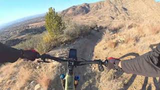
Jihad is a fun DH off of 365A that parallels it, but branches off to the north and drops you straight down to the parking lot. Jihad is loose, moderately steep, and has one challenging rock roll towards the bottom of it. There is a bail out option before this feature to the left where Jihad connects back into 365A if you aren't confident in your roll skills. Really fun trail and worth the extra bit of climbing after the middle finger

Tags
DropsJumpsRock gardensRock slabs

Local Trail Association

Traditionally Indigenous Territory

Recent Activity on Trail

Past Week
  • 0 rides
  •  
6 Months
  • 28 rides
  • 16.5 km avg distance
All
  • 117 rides
  • Last: Nov 7, 2026
c1c2c3c4
January
February
March
April
May
June
July
August
September
October
November
December
update trails status or condition

Jihad Trail Reports

statusdatedescription
Mar 2, 2023 @ 10:45pm
Mar 2, 2023
more »
Status:
on Mar 2, 2023
Dry
Avg: 3.88 (3 votes)
Your vote: 0

view (794)
close
      Directions to jihad trailhead (35.094350, -106.474900)

      Photos

      No photos have been added for Jihad yet, add a photo.

      Videos

      1 more »
      Jihad
      mtb
      4:25 | 26 | Sep 26, 2026 , Albuquerque
      3.7 ★★★★★
      3 Ratings
      5 ★ 33%
      4 ★ 33%
      3 ★
      2 ★ 33%
      1 ★

      3 Reviews & Comments

      cyrusmoqtaderi cyrusmoqtaderi
      Coming from trails that are black diamond due to difficulty and tech skill (bootleg canyon, NV) , I'd say this was not that enjoyable. It was loose but also not set up well for biking, so felt like a lot of unflowy turns with a weird rhythm overall. The drop isn't bad on its own but it ends with an awkward loose turn and isn't great.

      Not that hard of a trail, but feels more like a patchwork of weird turns vs a hard flowy challenge. Wouldn't do it again.
      dylan-s
      Was very loose when I rode it. 3-4” deep kitty litter in all the wrong places. Drop 6 ft before a loose corner with a large rock at the apex. Rock roll into a loose gully at a turn with rocks on both sides.
      OZEzJ
      Crazy fun steep and rowdy DH, definitely worth it

      We hope you've been enjoying Trailforks!

      Create a FREE account to view all trail reviews and much more.

      • By brahhhTF Pro & contributors
      • #427867 - 1,137 views

      Frequently Asked Questions

      ▼ Where is Jihad located?
      Jihad is located in Sandia Foothills - South, Albuquerque, New Mexico, United States. It is part of the Sandia Foothills - South trail network. The trailhead is located at coordinates 35.09435, -106.4749.
      ▼ How hard is Jihad?
      Jihad is rated as Black Diamond difficulty. The physical rating is Hard. The average grade is 7.6%. The climb difficulty is rated Double Black Diamond.
      ▼ What is the elevation gain for Jihad?
      Jihad has 88 ft of elevation gain. The trail has 280 ft of elevation descent. The elevation ranges from 6,194 ft to 6,475 ft.
      ▼ Is Jihad a point to point trail?
      Jihad is not a point to point trail. The direction is Downhill Primary. The trail type is singletrack.
      ▼ How long is Jihad?
      Jihad is 2,536 ft long. The trail type is singletrack.
      ▼ Are dogs allowed on Jihad?
      Yes, dogs are allowed on Jihad. Please keep dogs on a leash where required and clean up after them.
      ▼ When is the best time of year to ride Jihad?
      Based on activity log data, the most popular months to ride Jihad are:
      • October (13 activities)
      • February (11 activities)
      • September (8 activities)
      Check the reports page for current trail conditions.
      ▼ How do I access Jihad? Where is the closest parking trailhead?
      The closest parking and trailhead locations to Jihad are: View all parking locations in the area.
      ▼ How long does it take to ride Jihad?
      Based on recorded activities, it takes an average of 6 minutes to ride Jihad. The trail is 2,536 ft long. Actual times will vary based on fitness level, conditions, and pace. View recent activity logs for more details.
      ▼ How busy is Jihad?
      Jihad is a very popular trail. There have been 767 recorded activities on this trail. The trail has received 794 check-ins. View recent activity on this trail.

      Hit the Trail

      Open in App

      Get this trail on your phone instantly.

      open trail in app

      Download Trail

      Save to wishlist, Garmin & download.
      save the trail

      Find Related Routes

      Find routes and users activities that include this trail.
      find routes for this trail

      You must enter a description before submitting.

