
more stats
2.7 miles
Distance
-3,341 ft
Descent
00:51:26
Avg time
-3,341 ft
Altitude change
4,556 ft
Altitude min
7,897 ft
Altitude max
7,897 ft
Altitude start
4,557 ft
Altitude end
-23.6%
Grade
-91.1%
Grade max
39 ft
Distance climb
3 miles
Distance down
135 ft
Distance flat
00:51:26
Avg time

Kopflplatte Details

  • Activities
    • Mountain Bike
    • E-Bike
    • Hike
    • Trail Running
  • Riding Area
    Vinschgau
    Schlanders
  • Ref Number
    21&22
  • Difficulty Rating
  • Local Popularity
    5 in Mountain Biking heatmap [+]
    • 5 in E-Biking
    • 5 in Trail Running
    • 5 in Hiking
  • Global Ranking
    #66397 in Mountain Biking [+]
    • #148300 in E-Biking
    • #221063 in Trail Running
    • #211915 in Hiking
  • National Ranking
    #5,624 in Mountain Biking · Italy [+]
    • #14,036 in E-Biking
    • #6,377 in Trail Running
    • #6,169 in Hiking
  • Hiking SAC Scale
    T1 Hiking
  • Trail Type
    Singletrack
  • Bike Type
    AM
  • Direction
    Downhill Only
    Popular Direction Shown
  • Climb Difficulty
    Green
  • Physical Rating
    Moderate
  • Trail Visibility
    Always easy to follow
  • Season
    better if done in spring or autumn as it's totally south exposed.
  • Alpine Trail
    Yes
  • eBike Allowed
    Yes up to Class 1

long epic alpine trail winding from the peak of Kopflplatte to Spondinig...1700m of pleasure.

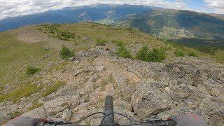
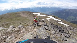
the first part from the summit to the beginning of the wood is an easy single track on alpine meadown rocky terrain.
the second part, at the beginning of the wood is a very steep, narrow offcamber section on a very grippy and loamy soil with some tight switchbacks.
After this section the trail becomes basically super flowy and fast, always on good loamy soil.

Access Info

the access is long and painful: from spondinig you need to traverse on trail first and fireroads till Allitz to then take a road bringing you to Tanas.
From Tanas follow the fireroad leading to the Tanaser Stierhutte. From here push or carry your bike till the summit following the long trail traversing south

Disclaimer

hiking trail....be respectful.

Recent Activity on Trail

Past Week
  • 0 rides
  •  
6 Months
  • 0 rides
  •  
All
  • 0 rides
  • Last: Apr 8, 2023
update trails status or condition

Kopflplatte Trail Reports

Status:
on Aug 22, 2025
Prevalent Mud
Avg: 3.99 (2 votes)
Your vote: 0

view (1)
close
      Directions to kopflplatte trailhead (46.660440, 10.637620)

      Photos

      No photos have been added for Kopflplatte yet, add a photo.

      Videos

      2 more »
      Vinschgau Köpflplatte Trail Juli 2023
      mtb
      26:47 | 281 | Sep 21, 2023 , Schlanders
      Kopflplatte by Alice Bianchini
      mtb
      8:17 | 625 | Jun 27, 2022 , Schlanders
      4.0 ★★★★★
      2 Ratings
      5 ★
      4 ★ 100%
      3 ★
      2 ★
      1 ★

      2 Reviews & Comments

      Albe79 Albe79
      Fatto oggi, non è un granché, la prima parte della discesa anche bella con panorami sulla vallata, la sezione intermedia con tornanti da noose press e un passaggio difficile e molto stretto.
      Poi banale sentiero/carraia. L'ultimo tratto dopo le case riprende la carraia, interessante solo l'ultimo tratto prima della stazione, anche se ci sono rilanci da fare a piedi.
      Come ha detto il ragazzo prima....se non hai più altri sentieri da fare, questa può essere un' opzione.
      crisotop crisotop
      I’m a bit torn on that trail - it’s got an epic summit with beautiful views on a deserted hillside. The description is spot on: top section meadowy (but hard to find sometimes Smile , then a very tricky steep and tight wood section (definitely black s2, maybe 3 in two spots), then the trail turns very much into a steep straight line. Although on dreamy soil with short cool sections, but all in all a lot of braking down straights.
      To sum up: Very cool Tour if you’ve already seen all the other trails in the region Wink
      Uphill is long but moderately steep. From Tenaser Stierhuette you have to walk the bike on very narrow cowpaths and short rocky sections. We carried the bikes most of the time.
      Gasthof Paflur (start of the fireroad) is the last spot to get water / food. There are a couple of uncharted river crossings to the top, but no springs

      We hope you've been enjoying Trailforks!

      Create a FREE account to view all trail reviews and much more.

      • By alexmarengoTF Pro & contributors
      • #547745 - 1,111 views

      Frequently Asked Questions

      ▼ Where is Kopflplatte located?
      Kopflplatte is located in Vinschgau, Schlanders, Italy. It is part of the Vinschgau trail network. The trailhead is located at coordinates 46.66044, 10.63762.
      ▼ How hard is Kopflplatte?
      Kopflplatte is rated as Red difficulty. The physical rating is Moderate. The average grade is 23.6%. The climb difficulty is rated Green.
      ▼ What is the elevation gain for Kopflplatte?
      The trail has 3,341 ft of elevation descent. The elevation ranges from 4,556 ft to 7,897 ft.
      ▼ Is Kopflplatte a point to point trail?
      Yes, Kopflplatte is a point to point trail. The direction is Downhill Only. The trail type is singletrack.
      ▼ How long is Kopflplatte?
      Kopflplatte is 2.7 miles long. The trail type is singletrack.
      ▼ Are dogs allowed on Kopflplatte?
      There is no information about dogs being allowed on Kopflplatte. Check with local trail managers or the trail page for the latest access rules.
      ▼ When is the best time of year to ride Kopflplatte?
      Kopflplatte is best visited during: better if done in spring or autumn as it's totally south exposed..
      ▼ How do I access Kopflplatte? Where is the closest parking trailhead?
      The closest parking and trailhead locations to Kopflplatte are: View all parking locations in the area.
      ▼ How long does it take to ride Kopflplatte?
      The estimated time to ride Kopflplatte is approximately 51 minutes. The trail is 2.7 miles long. Actual times will vary based on fitness level, conditions, and pace.
      ▼ How busy is Kopflplatte?
      Kopflplatte is a less popular trail with lighter traffic. There have been 1 recorded activities on this trail. The trail has received 1 check-ins. View recent activity on this trail.

      Hit the Trail

      Open in App

      Get this trail on your phone instantly.

      open trail in app

      Download Trail

      Save to wishlist, Garmin & download.
      save the trail

      Find Related Routes

      Find routes and users activities that include this trail.
      find routes for this trail

      You must enter a description before submitting.

