


more stats
1.1 miles
Distance
44 ft
Climb
-421 ft
Descent
00:08:06
Avg time
-377 ft
Altitude change
1,893 ft
Altitude min
2,270 ft
Altitude max
2,270 ft
Altitude start
1,893 ft
Altitude end
-6.7%
Grade
-30.9%
Grade max
18%
Grade min
748 ft
Distance climb
4,787 ft
Distance down
72 ft
Distance flat
00:08:06
Avg time

La Diagonal Details

  • Activities
    • Mountain Bike
    • E-Bike
    • Winter Fat Bike
    • Hike
    • Trail Running
  • Riding Area
  • Difficulty Rating
  • Voted Difficulty
    Blue (2 votes)
  • Local Popularity
    85 in Mountain Biking [+]
    • 95 in E-Biking
    • 90 in Trail Running
    • 80 in Hiking
    • 5 in Winter Fat Biking
  • Global Ranking
    #103031 in Mountain Biking [+]
    • #57713 in E-Biking
    • #76952 in Trail Running
    • #94268 in Hiking
    • #25587 in Winter Fat Biking
  • National Ranking
    #7,636 in Mountain Biking · Spain [+]
    • #5,650 in E-Biking
    • #6,329 in Trail Running
    • #6,190 in Hiking
    • #61 in Winter Fat Biking
  • Trail Type
    Singletrack
  • Bike Type
    AM, XC, Fat
  • Direction
    Downhill Primary
  • Climb Difficulty
    Black Diamond
  • Physical Rating
    Moderate
  • Season
    All year.
  • Dogs Allowed
    Yes
  • eBike Allowed
    Yes up to Class 1
  • TTFs on Trail
    Rock Face, Rock Garden, Skinny
  • Ride in Rain
    Yes
  • Year Opened
    2017

The track runs along the forest with some exposed and open parts with nice views. Mostly downhill, with a few uphill.

Narrow trail that widens at the end of its first third. Some technical trial parts, that allow riders to ride them fast, full of rocks and roots. Mostly no loose stones in the technical parts, just on the wider bits of the trail.

Careful as the trail is used by some runners to go uphill, they tend to stop and let bikers go on. At the lowest part of the trail, during weekends, some families can be walking by with kids and dogs.

Access Info

Easy acces from "Hospital del Tòrax".

Recent Activity on Trail

Past Week
  • 2 rides
  • 9 miles average
6 Months
  • 18 rides
  • 13 miles avg distance
All
  • 236 rides
  • Last: Oct 21, 2026
update trails status or condition

La Diagonal Trail Reports

statusdatedescription
Jan 31, 2026 @ 5:33pm (Europe/Madrid)
Jan 31, 2026
arbre caigut
Jun 8, 2025 @ 8:22am
Jun 8, 2025
Sec però encara en bones condicions Sense obstacles
Jan 24, 2025 @ 8:02am
Jan 24, 2025
Totalmente limpia!
Dec 24, 2024 @ 7:38am
Dec 24, 2024
Arbol caido a mitad de camino.
Nov 2, 2024 @ 12:10pm
Nov 2, 2024
more »
Status:
on Jan 31, 2026
Avg: 4.33 (17 votes)
Your vote: 0

view (1,603)
close
      Directions to la-diagonal trailhead (41.611560, 1.988230)

      Photos

      2 more »
      mtb
      139 |
      Aug 8, 2023 @ 1:38pm
      Aug 8, 2023
      mtb
      261 |
      Nov 21, 2017 @ 7:03am
      Nov 21, 2017

      Videos

      2 more »
      La Diagonal
      mtb
      23:31 | 289 | Aug 4, 2022 , Terrassa
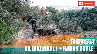
      Terrassa - La Diagonal + Harry Style
      ebike
      6:56 | 418 | Sep 15, 2022 , Terrassa

      Trail Lists

      Routes with this trail

      16 miles • 2,938 ft • 5 • Loop •
      bajada por diagonal y ratafia
      31 miles • 4,835 ft • 15 •
      Combinado de trails por el Obac, Can Torres y St Feliu del Raco
      4.4 ★★★★★
      17 Ratings
      5 ★ 41%
      4 ★ 53%
      3 ★ 6%
      2 ★
      1 ★

      6 Reviews & Comments

      FanaBike FanaBike
      La pista Diagonal comienza con un par de pasos un poco complicados, más de nivel rojo/rojo oscuro, si tu nivel no es muy alto. El resto de la pista se hace bastante bien y es divertida, algún punto un poco más complicado, pero sin llegar a ser peligroso, con un nivel medio vas bien.
      mylines mylines
      Hoy era un rio, la roca tiene buen grip por eso, pero las lluvias han pasado factura.
      b4Gqvy b4Gqvy
      Entretenido y largo, hay que pedalear algún tramo.

      We hope you've been enjoying Trailforks!

      Create a FREE account to view all trail reviews and much more.

      • By Piroclast & contributors
      • #109115 - 1,872 views

      Frequently Asked Questions

      ▼ Where is La Diagonal located?
      La Diagonal is located in Terrassa, Spain. It is part of the Terrassa trail network. The trailhead is located at coordinates 41.61156, 1.98823.
      ▼ How hard is La Diagonal?
      La Diagonal is rated as Blue difficulty. The physical rating is Moderate. The average grade is 6.7%. The climb difficulty is rated Black Diamond.
      ▼ What is the elevation gain for La Diagonal?
      La Diagonal has 44 ft of elevation gain. The trail has 421 ft of elevation descent. The elevation ranges from 1,893 ft to 2,270 ft.
      ▼ Is La Diagonal a point to point trail?
      La Diagonal is not a point to point trail. The direction is Downhill Primary. The trail type is singletrack.
      ▼ How long is La Diagonal?
      La Diagonal is 1.1 miles long. The trail type is singletrack.
      ▼ Are dogs allowed on La Diagonal?
      Yes, dogs are allowed on La Diagonal. Please keep dogs on a leash where required and clean up after them.
      ▼ When is the best time of year to ride La Diagonal?
      La Diagonal is best visited during: All year..
      ▼ How do I access La Diagonal? Where is the closest parking trailhead?
      The closest parking and trailhead locations to La Diagonal are: View all parking locations in the area.
      ▼ How long does it take to ride La Diagonal?
      Based on recorded activities, it takes an average of 8 minutes to ride La Diagonal. The trail is 1.1 miles long. Actual times will vary based on fitness level, conditions, and pace. View recent activity logs for more details.
      ▼ How busy is La Diagonal?
      La Diagonal is a very popular trail. There have been 1,564 recorded activities on this trail. The trail has received 1,603 check-ins. View recent activity on this trail.

      Hit the Trail

      Open in App

      Get this trail on your phone instantly.

      open trail in app

      Download Trail

      Save to wishlist, Garmin & download.
      save the trail

      Find Related Routes

      Find routes and users activities that include this trail.
      find routes for this trail

      You must enter a description before submitting.

