more stats
3,271 ft
Distance
-317 ft
Descent
00:04:39
Avg time
-317 ft
Altitude change
2,526 ft
Altitude min
2,842 ft
Altitude max
2,842 ft
Altitude start
2,526 ft
Altitude end
-9.7%
Grade
-27.6%
Grade max
-1.1%
Grade min
3,271 ft
Distance down
00:04:39
Avg time

La Eugi Details

  • Activities
    • Mountain Bike
    • E-Bike
    • Hike
    • Trail Running
  • Riding Area
    Aibar
    Sanguesa
  • Difficulty Rating
  • Local Popularity
    70 in Mountain Biking [+]
    • 5 in E-Biking
    • 5 in Trail Running
    • 5 in Hiking
  • Global Ranking
    #87927 in Mountain Biking [+]
    • #107234 in E-Biking
    • #145427 in Trail Running
    • #140944 in Hiking
  • Hiking SAC Scale
    T1 Hiking
  • Trail Type
    Singletrack
  • Bike Type
    AM, XC
  • Direction
    Both Directions
    Popular Direction Shown
  • Climb Difficulty
    Black Diamond
  • Physical Rating
    Moderate
  • Trail Visibility
    Sometimes hard to follow
  • Family Friendly
    Yes
  • Dogs Allowed
    Yes
  • eBike Allowed
    Yes up to Class 1
  • TTFs on Trail
    Skinny
  • Land Owner
    No Dig no Fun

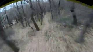
Sendero por bosque, en otoño dificil de seguir, gracias a los troncos que hacen de marcaje en las curvas, tramo final de fuerte pendiente de subida, y después del campo, paso de la alambrada. Este paso en descenso se puede saltar!

Local Trail Association

Recent Activity on Trail

Past Week
  • 1 rides
  • 10 miles average
6 Months
  • 5 rides
  • 22 miles avg distance
All
  • 21 rides
  • Last: Jun 2, 2026
c1c2c3c4
January
February
March
April
May
June
July
August
September
October
November
December
update trails status or condition

La Eugi Trail Reports

statusdatedescription
Jun 25, 2024 @ 12:05am
Jun 25, 2024
TOP. Senda con buen firme y mucho flow. Fácil de seguir. Ojo al manillar al pasar entre algunos árboles
Aug 26, 2023 @ 3:57am
Aug 26, 2023
Jan 12, 2023 @ 5:58pm
Jan 12, 2023
Nov 13, 2021 @ 7:11am
Nov 13, 2021
Ciclar sobre ese lecho de hojas, sin ver el trazado, solo el GPS y los troncos en los laterales que nos van guiando en la subida, llevadera, entre...
Jul 30, 2021 @ 11:35pm
Jul 30, 2021
more »
Status:
on Jun 25, 2024
Ideal
Avg: 4.29 (4 votes)
Your vote: 0

view (114)
close
3D
Trail Conditions
  • Unknown
  • Snow Groomed
  • Snow Packed
  • Snow Covered
  • Snow Cover Partial
  • Freeze/thaw Cycle
  • Icy
  • Prevalent Mud
  • Wet
  • Variable
  • Ideal
  • Dry
  • Very Dry
Trail Flow (Ridden Direction)
Trailforks scans users ridelogs to determine the most popular direction each trail is ridden. A good flowing trail network will have most trails flowing in a single direction according to their intension.
The colour categories are based on what percentage of riders are riding a trail in its intended direction.
  • > 96%
  • > 90%
  • > 80%
  • > 70%
  • > 50%
  • < 50%
  • bi-directional trail
  • no data
Trail Last Ridden
Trailforks scans ridelogs to determine the last time a trail was ridden.
  • < 2 days
  • < 1 week
  • < 2 weeks
  • < 1 month
  • < 6 months
  • > 6 months
Trail Ridden Direction
The intended direction a trail should be ridden.
  • Downhill Only
  • Downhill Primary
  • Both Directions
  • Uphill Primary
  • Uphill Only
  • One Direction
Contribute Details
Colors indicate trail is missing specified detail.
  • Description
  • Photos
  • Description & Photos
  • Videos
Trail Popularity ?
Trailforks scans ridelogs to determine which trails are ridden the most in the last 9 months. Trails are compared with nearby trails in the same city region with a possible 25 colour shades. Think of this as a heatmap, more rides = more kinetic energy = warmer colors.
  • most popular
  • popular
  • less popular
  • not popular
ATV/ORV/OHV Filter
Max Vehicle Width
inches
US Cell Coverage
Legend
cell carrier legend

Radar Time
Activity Recordings
Trailforks uses anonymized public activity data. ?
Activity Recordings
Trailforks uses anonymized public activity data. ?
Personal Heatmap
Activity Types
all / none
Options
2
Date range month
Winter Trails
Warning A routing network for winter maps does not exist. Selecting trails using the winter trails layer has been disabled.
Missing Trails
Most Popular
Least Popular
Trails are colored based on popularity. The more popular a trail is, the more red. Less popular trails trend towards green.
Jump Magnitude Heatmap
Heatmap of where riders jump on trails. Zoom in to see individual jumps, click circles to view jump details.
BC Backroad Status

Service Road Atlas is a free to use, community-driven service for viewing and creating reports on the numerous back-country service roads around B.C. and Alberta.

map legend
Slope Aspect
Direction the slope faces
Flat N NE E SE S SW W NW
Trails Deemphasized
Trails are shown in grey.
disable
Only show trails with no bike usage.
Enable
Suggested Layers
Based on selected activity type

    Save the current map location and zoom level as your default home location whenever this page is loaded.

    Save
        Directions to la-eugi trailhead (42.630350, -1.375680)

        Photos

        11 more »
        27 |
        Nov 13, 2021 @ 9:15am
        Nov 13, 2021
        23 |
        Nov 13, 2021 @ 9:14am
        Nov 13, 2021
        21 |
        Nov 13, 2021 @ 9:14am
        Nov 13, 2021
        30 |
        Nov 13, 2021 @ 9:14am
        Nov 13, 2021

        Videos

        2 more »
        La Eugi y La Termedia
        4:46 | 249 | Jan 23, 2020 , Sanguesa
        Video resumen de La Eugi y La Termedia
        0:56 | 54 | Jan 27, 2020 , Sanguesa

        Routes with this trail

        5.0 17 miles 3,448 ft 12 Loop
        Nueva entrega de senderos de Aibar. Con bajadas completamete nuevas y otras que retomamos del a con...
        4.0 16 miles 2,879 ft 5 Loop
        Ruta Exigente con cuatro tramos muy buenos de bajada,partiendo desde el pueblo de Aibar.
        3.0 27 miles 5,052 ft 13 Loop
        Peremusa BTT nace como la union lógica, y fluida de todos senderos y bajadas típicos de la zona de...

        Reviews / Comments

        No reviews yet, be the first to write a review or ask a question.
        Use trail reports to comment on trail conditions.


        We hope you've been enjoying Trailforks!

        Create a FREE account to view trail comments and much more.

        • By Esain & contributors
        • #245757 - 991 views

        Frequently Asked Questions About La Eugi

        Where is La Eugi located?
        La Eugi is located in Aibar, Sanguesa, Spain. It is part of the Aibar trail network. The trailhead is located at coordinates 42.63035, -1.37568.
        How hard is La Eugi?
        La Eugi is rated as Blue difficulty. The physical rating is Moderate. The average grade is 9.7%. The climb difficulty is rated Black Diamond.
        What is the elevation gain for La Eugi?
        The trail has 97 m of elevation descent. The elevation ranges from 770 m to 866 m.
        Is La Eugi a point to point trail?
        La Eugi is not a point to point trail. The direction is Both Directions. The trail type is singletrack.

        Hit the Trail

        Open in App

        Get this trail on your phone instantly.
        open trail in app

        Download Trail

        Save to wishlist, Garmin & download.
        save the trail

        Find Related Routes

        Find routes and users activities that include this trail.
        find routes for this trail

        You must enter a description before submitting.