La Paco Details
-
Activities
- Mountain Bike
-
Riding AreaCerro Catedral
San Carlos de Bariloche -
Difficulty Rating
-
Voted DifficultyBlack Diamond (2 votes)
-
Trail TypeSingletrack
-
Bike TypeAM, XC
-
DirectionDownhill PrimaryPopular direction shown
-
Climb DifficultyGreen
-
Physical RatingEasy
-
Dogs AllowedYes
-
TTFs on TrailBridge, Jump, Rock Face, Rock Garden
-
Global Ranking#49521 in Mountain Biking
-
Local Popularity100 in Mountain Biking
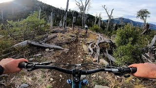
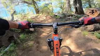
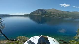
La paco es uno de los recorridos más transitados por los ciclistas tanto locales como los que visitan Bariloche. Es uno recorrido exclusivo para bicis dentro del parque nacional y conecta el cerro catedral con el Lago Gutierrez con la posibilidad de aprovechar para combinar bici y lago.
Su recorrido es bastante flow y alterna lugares más planos con algunas partes más tecnicas en el sector inferior que pueden ser dificiles cuando esta muy seco el terreno.
Sin duda es una de las que si o si tenes que hacer en Bariloche
Traditionally Indigenous Territory
More Stats for La Paco mountain bike trail trail
-
Altitude change-720 ft
-
Altitude min2,702 ft
-
Altitude max3,450 ft
-
Altitude start3,422 ft
-
Altitude end2,703 ft
-
Grade-3.4%
-
Grade max-37.3%
-
Grade min33.7%
-
Distance climb1 mile
-
Distance down3 miles
-
Distance flat1,266 ft
-
Avg time00:45:04
- view trail stats
-
Layers w
- Map Content
- More Layers
- Pro
- Pro
- Pro
- Pro
- Pro
- Pro
- Pro
- Pro
-
Upgrade to

- Unknown
- Snow Groomed
- Snow Packed
- Snow Covered
- Snow Cover Partial
- Freeze/thaw Cycle
- Icy
- Prevalent Mud
- Wet
- Variable
- Ideal
- Dry
- Very Dry
The colour categories are based on what percentage of riders are riding a trail in its intended direction.
- > 96%
- > 90%
- > 80%
- > 70%
- > 50%
- < 50%
- bi-directional trail
- no data
- < 2 days
- < 1 week
- < 2 weeks
- < 1 month
- < 6 months
- > 6 months
- Downhill Only
- Downhill Primary
- Both Directions
- Uphill Primary
- Uphill Only
- One Direction
- Description
- Photos
- Description & Photos
- Videos
- most popular
- popular
- less popular
- not popular

- mountain biking recent
- mountain biking (>6 month)
- hiking (1 year)
- moto (1 year)
- Downhill Ski
- Backcountry Ski
- Nordic Ski
- Snowmobile
Save the current map location and zoom level as your default home location whenever this page is loaded.
SaveLa Paco Trail Reports
Recent Ridelog Activity on Trail
- 0 rides
- 53 rides
- 13 miles avg distance
- 500 rides
- Last: Apr 29, 2024

Photos
Routes with this trail
5 Reviews & Comments
We hope you've been enjoying Trailforks!
Create a FREE account to view trail comments and much more.
Videos
Nearby Trails
- Camino A Open E Ixs 3,783 ft
- Upper Zacalapata 3,835 ft
- Camino Acceso A El Mario 3,835 ft
- Trail To Bumps 3,924 ft
- El Bravo 3,953 ft
- By MTBar
 & contributors
 - #29624 - 5,136 views
- follow/subscribe
- login to download gpx or kml files.
You must enter a description before submitting.