

more stats
4,482 ft
Distance
-676 ft
Descent
00:10:36
Avg time
-676 ft
Altitude change
826 ft
Altitude min
1,504 ft
Altitude max
1,502 ft
Altitude start
827 ft
Altitude end
-15.1%
Grade
-56.9%
Grade max
1.5%
Grade min
430 ft
Distance climb
3,871 ft
Distance down
184 ft
Distance flat
00:10:36
Avg time

La Strega Details

  • Activities
    • Mountain Bike
    • E-Bike
  • Riding Area
    Monte Calvi Trail Area
    Campiglia Marittima
  • Difficulty Rating
  • Local Popularity
    85 in Mountain Biking [+]
    • 85 in E-Biking
  • Global Ranking
    #41948 in Mountain Biking [+]
    • #24096 in E-Biking
  • National Ranking
    #3,961 in Mountain Biking · Italy [+]
    • #2,769 in E-Biking
  • Trail Type
    Singletrack
  • Bike Type
    DH
  • Direction
    Downhill Only
    Popular Direction Shown
  • Physical Rating
    Hard
  • Trail Visibility
    Always easy to follow
  • Dogs Allowed
    Yes
  • eBike Allowed
    Yes up to Class 1
  • TTFs on Trail
    A-Frame, Drop, Rock Face, Rock Garden
  • Land Owner
    Montecalvi trail area

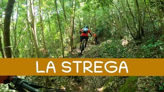
The departure starts from "campo alla strega" and hence the name of the trail.
the first part is characterized by curves and drops in sequence that are not too difficult, you reach a road to cross and from there on the games become more difficult.
the second part is characterized by a ground of earth and stones with some passages on fixed rocks.
BONUS halfway through the second part you walk alongside an old Etruscan mine where in winter you can see the release of steam and water (geothermal).

La partenza parte da "campo alla strega" e da qui il nome del sentiero.
la prima parte è caratterizzata da curve e dislivelli in sequenza non troppo difficili, si arriva ad una strada da attraversare e da lì in poi i giochi diventano più difficili.
la seconda parte è caratterizzata da un fondo di terra e sassi con alcuni passaggi su rocce fisse.
BONUS A metà della seconda parte si costeggia un'antica miniera etrusca dove in inverno è possibile vedere l'uscita di vapore e acqua (geotermia).

Tags

Local Trail Association

Recent Activity on Trail

Past Week
  • 0 rides
  •  
6 Months
  • 5 rides
  • 10 miles avg distance
All
  • 65 rides
  • Last: Oct 16, 2026
c1c2c3c4
January
February
March
April
May
June
July
August
September
October
November
December
Status:
on Jul 1, 2026
Avg: 4.42 (11 votes)
Your vote: 0

view (631)
close
      Directions to la-strega trailhead (43.084190, 10.631600)

      Photos

      14 more »
      mtb
      178 |
      Aug 20, 2020 @ 7:00am
      Aug 20, 2020
      mtb
      244 |
      Aug 20, 2020 @ 7:00am
      Aug 20, 2020
      mtb
      262 |
      Aug 20, 2020 @ 7:00am
      Aug 20, 2020
      report
      mtb
      74 |
      Dec 1, 2021 @ 3:28am
      Dec 1, 2021

      Videos

      3 more »
      youtuber Strega - Montecalvi Enduro Area
      mtb
      3:47 | 389 | Feb 28, 2023 , Campiglia Marittima
      youtuber MTB Monte Calvi 27.05.2023 sentiero BALZO ALLA...
      mtb
      6:11 | 312 | May 28, 2023 , Campiglia Marittima
      Back on the Trails That Made Me Cry (Almost)...
      mtb
      26:54 | 213 | Apr 30, 2025 , Campiglia Marittima
      4.8 ★★★★★
      11 Ratings
      5 ★ 73%
      4 ★ 27%
      3 ★
      2 ★
      1 ★

      Reviews / Comments

      No reviews yet, be the first to write a review or ask a question.
      Use trail reports to comment on trail conditions.


      We hope you've been enjoying Trailforks!

      Create a FREE account to view all trail reviews and much more.

      • By riccardo-nanniTF Pro SMTBC & contributors
      • #259336 - 1,604 views

      Frequently Asked Questions

      ▼ Where is La Strega located?
      La Strega is located in Monte Calvi Trail Area, Campiglia Marittima, Italy. It is part of the Monte Calvi Trail Area trail network. The trailhead is located at coordinates 43.08419, 10.6316.
      ▼ How hard is La Strega?
      La Strega is rated as Red difficulty. The physical rating is Hard. The average grade is 15.1%.
      ▼ What is the elevation gain for La Strega?
      The trail has 676 ft of elevation descent. The elevation ranges from 826 ft to 1,504 ft.
      ▼ Is La Strega a point to point trail?
      Yes, La Strega is a point to point trail. The direction is Downhill Only. The trail type is singletrack.
      ▼ How long is La Strega?
      La Strega is 4,482 ft long. The trail type is singletrack.
      ▼ Are dogs allowed on La Strega?
      Yes, dogs are allowed on La Strega. Please keep dogs on a leash where required and clean up after them.
      ▼ When is the best time of year to ride La Strega?
      Based on activity log data, the most popular months to ride La Strega are:
      • June (15 activities)
      • April (6 activities)
      • May (4 activities)
      Check the reports page for current trail conditions.
      ▼ How do I access La Strega? Where is the closest parking trailhead?
      The closest parking and trailhead locations to La Strega are: View all parking locations in the area.
      ▼ How long does it take to ride La Strega?
      Based on recorded activities, it takes an average of 11 minutes to ride La Strega. The trail is 4,482 ft long. Actual times will vary based on fitness level, conditions, and pace. View recent activity logs for more details.
      ▼ How busy is La Strega?
      La Strega is a very popular trail. There have been 629 recorded activities on this trail. The trail has received 631 check-ins. View recent activity on this trail.

      Hit the Trail

      Open in App

      Get this trail on your phone instantly.

      open trail in app

      Download Trail

      Save to wishlist, Garmin & download.
      save the trail

      Find Related Routes

      Find routes and users activities that include this trail.
      find routes for this trail

      You must enter a description before submitting.

