


more stats
4.3 miles
Distance
188 ft
Climb
-2,754 ft
Descent
01:07:24
Avg time
-2,566 ft
Altitude change
5,192 ft
Altitude min
7,758 ft
Altitude max
7,758 ft
Altitude start
5,194 ft
Altitude end
-11.2%
Grade
-65.8%
Grade max
36.2%
Grade min
2,457 ft
Distance climb
4 miles
Distance down
259 ft
Distance flat
01:07:24
Avg time

Ladybug Trail (Lower) Details

  • Activities
    • Mountain Bike
    • Horse
    • Hike
    • Trail Running
  • Riding Area
  • Difficulty Rating
  • Local Popularity
    85 in Mountain Biking heatmap [+]
    • 100 in Trail Running
    • 90 in Hiking
    • 5 in Horseback
  • Global Ranking
    #79589 in Mountain Biking [+]
    • #82123 in Trail Running
    • #88318 in Hiking
    • #20375 in Horseback
  • State Ranking
    #1,034 in Mountain Biking · Arizona [+]
    • #1,225 in Trail Running
    • #1,707 in Hiking
    • #737 in Horseback
  • Trail Type
    Singletrack
  • Bike Type
    AM, XC
  • Direction
    Downhill Primary
    Popular Direction Shown
  • Climb Difficulty
    Black Diamond
  • Physical Rating
    Hard
  • Trail Visibility
    Always easy to follow
  • Dogs Allowed
    Yes
  • Land Owner
    Coronado National Forest

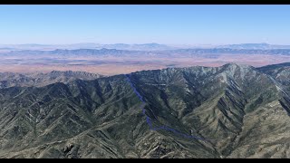
Lower Ladybug Trail is access by a .7 mile ride/hike a bike up from Turkey Flat Trail. Once at the jct stay left and head mostly down hill until you reach the Angle Orchard Trail Head Parking lot. Lower Ladybug is the most MTB friendly section of the Ladybug Trail. That said, it's a technically demanding, big mountain back country trail. Arizona riders familiar with Bug Springs and Incinerator Ridge on Mt Lemmon will enjoy this trail. It's quite a contrast from the recently restored Arcadia trail. It's a level up and for those that appreciate adventure and challenge.

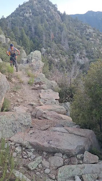
Main challenges that exist are tight switchbacks that are clear-able. but take confident bike handling, a couple of punchy climb/ near hike a bike sections and high speed descending with loose decomposed granite, rocks and lots of embedded square edges. Riders that tend to like more purpose built MTB trail experiences, l may be frustrated with this trail on their first go. Improvements/restoration will continue to be seen on Ladybug in 2024. While that will make the trail more user friendly to a broader skill set of riders, this trail will always be rugged and challenging.

Disclaimer

For Mountain Bikers Recommend Starting at Turkey Flat and riding down to Angle Orchard

Tags
Hike-a-bikeTight and twisty

Local Trail Association

Traditionally Indigenous Territory

Recent Activity on Trail

Past Week
  • 0 rides
  •  
6 Months
  • 0 rides
  •  
All
  • 20 rides
  • Last: Oct 24, 2026
c1c2c3c4
January
February
March
April
May
June
July
August
September
October
November
December
update trails status or condition

Ladybug Trail... Trail Reports

statusdatedescription
May 18, 2026 @ 5:36pm (America/Phoenix)
May 18, 2026
Lower Ladybug is free of down trees as of May 16th 2026. SDMB volunteers removed 3 down trees with hand tools and rerouted about 60 ft of trail...
Mar 22, 2026 @ 11:00am (America/Phoenix)
Mar 22, 2026
About 3 downed trees across the trail within the first 2 miles of the top. They're mostly found where the trail transitions to a climb. All are...
Dec 29, 2025 @ 8:15pm (America/Phoenix)
Dec 29, 2025
Rode Dec 28th 2025: Trail is in overall great shape. Amazing moisture and grip on this report ride. Trail did get scoured on the lower 1/2 mile...
Jun 19, 2025 @ 7:53am
Jun 19, 2025
Fire impacted the trail about 1 mile below the Turkey Flat Intersection. Burned about 1/4 section of trail. Overall fire was 8 acres. Luckily the...
May 9, 2025 @ 8:47pm
May 9, 2025
4/28/25 ride date. Trail is all clear and in good shape. Who ever rode the trail and skidded into and around many of the switchbacks is a shit head.
more »
Status:
on May 18, 2026
Dry
Avg: 4.26 (6 votes)
Your vote: 0

view (115)
close
      Directions to ladybug-trail-lower trailhead (32.632540, -109.810180)

      Photos

      78 more »
      mtb
      122 |
      May 9, 2025 @ 8:50pm
      May 9, 2025
      mtb
      70 |
      May 9, 2025 @ 8:50pm
      May 9, 2025
      mtb
      67 |
      May 9, 2025 @ 8:50pm
      May 9, 2025
      mtb
      51 |
      May 9, 2025 @ 8:50pm
      May 9, 2025

      Videos

      3 more »
      Ladybug/Round the Mtn MTB Mt. Graham
      mtb
      14:48 | 634 | Jun 4, 2023 , Safford
      Ladybug
      mtb
      6:57 | 617 | Aug 3, 2020 , Safford
      mtb
      0:11 | 76 | Jun 15, 2023 , Safford

      Routes with this trail

      more »
      ★ 5.0 • 34 miles • 7,371 ft • 8 • Loop •
      The Graham Cracker Route but without the assistance of a shuttle. That means parking at Noon Creek Picnic...
      ★ 5.0 • 20 miles • 3,625 ft • 7 • Shuttled •
      Check individual trail reports before attempting this route. Conditions can be quite variable depending on...
      ★ 5.0 • 5 miles • 528 ft • 3 •
      The best way to ride Ladybug for MTB. It's an advanced ride. Come prepared. This trail is being revived...
      4.4 ★★★★★
      6 Ratings
      5 ★ 50%
      4 ★ 33%
      3 ★ 17%
      2 ★
      1 ★

      4 Reviews & Comments

      ino5VQ
      Once you get through switchback hell this trail rips!
      farmteamlb farmteamlb
      This one is a full value adventure, can't wait to get back. One you're past the hike a bike (which is probably 50% rideable honestly) you get wonderful techy and exposed riding on the ridge before switchbacking through the pines on your way to the saddle that deposits you onto the final half of the descent.

      The last 2 miles is amazing, and it is very clear the work that has gone into the trail to make it such a joy - great tread, drainage features, lots of small jumps, some optional larger ones, and a gorgeous water crossing right near the end. I even saw a few honest to god berms in the last mile - a rare sighting in Southern AZ.

      Huge thanks to the trail crews and SDMB for the great work out there.
      gravityjunkiepr gravityjunkiepr
      This trail will kick your ass and make you rethink mtbiking. Not for the faint hearted

      We hope you've been enjoying Trailforks!

      Create a FREE account to view all trail reviews and much more.

      • By jeffgicklhornTF Pro & contributors
      • #203042 - 4,533 views

      Frequently Asked Questions

      ▼ Where is Ladybug Trail (Lower) located?
      Ladybug Trail (Lower) is located in Pinaleno Mountains (Mt. Graham), Safford, Arizona, United States. It is part of the Pinaleno Mountains (Mt. Graham) trail network. The trailhead is located at coordinates 32.63254, -109.81018.
      ▼ How hard is Ladybug Trail (Lower)?
      Ladybug Trail (Lower) is rated as Black Diamond difficulty. The physical rating is Hard. The average grade is 11.2%. The climb difficulty is rated Black Diamond.
      ▼ What is the elevation gain for Ladybug Trail (Lower)?
      Ladybug Trail (Lower) has 188 ft of elevation gain. The trail has 2,754 ft of elevation descent. The elevation ranges from 5,192 ft to 7,758 ft.
      ▼ Is Ladybug Trail (Lower) a point to point trail?
      Ladybug Trail (Lower) is not a point to point trail. The direction is Downhill Primary. The trail type is singletrack.
      ▼ How long is Ladybug Trail (Lower)?
      Ladybug Trail (Lower) is 4.3 miles long. The trail type is singletrack.
      ▼ Are dogs allowed on Ladybug Trail (Lower)?
      Yes, dogs are allowed on Ladybug Trail (Lower). Please keep dogs on a leash where required and clean up after them.
      ▼ When is the best time of year to ride Ladybug Trail (Lower)?
      Based on activity log data, the most popular months to ride Ladybug Trail (Lower) are:
      • January (2 activities)
      • February (2 activities)
      • March (2 activities)
      Check the reports page for current trail conditions.
      ▼ How do I access Ladybug Trail (Lower)? Where is the closest parking trailhead?
      The closest parking and trailhead locations to Ladybug Trail (Lower) are: View all parking locations in the area.
      ▼ How long does it take to ride Ladybug Trail (Lower)?
      Based on recorded activities, it takes an average of 1 hour 7 minutes to ride Ladybug Trail (Lower). The trail is 4.3 miles long. Actual times will vary based on fitness level, conditions, and pace. View recent activity logs for more details.
      ▼ How busy is Ladybug Trail (Lower)?
      Ladybug Trail (Lower) is a very popular trail. There have been 112 recorded activities on this trail. The trail has received 115 check-ins. View recent activity on this trail.

      Hit the Trail

      Open in App

      Get this trail on your phone instantly.

      open trail in app

      Download Trail

      Save to wishlist, Garmin & download.
      save the trail

      Find Related Routes

      Find routes and users activities that include this trail.
      find routes for this trail

      You must enter a description before submitting.