

Open in App
Get this route on your phone instantly.
Trails are being improved but not frequently used. Conditions can be super variable and this route should be taken with caution and at your on risk. In general this is a physically demanding and bike skill heavy route.
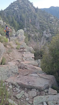
The best way to ride Ladybug for MTB. It's an advanced ride. Come prepared. This trail is being revived but it is still lightly used. Be humble and enjoy the amazing scenery. Leave a car at the Angle Orchard parking area. Drive up to the Turkey Flat Trail head. Ride/hike a bike up Turkey Flat trai. Go left onto Ladybug and begin the 2600ft descent to Angle Orchard. The first .5 mile of Ladybug down from Turkey Flat has some steep tight corners leading to a sun exposed area that is about 1/8 mile long that gets you back up onto the ridge and into the pines. SDMB tuned this section up in spring 2023 and it's running great. Once out of the pines you get onto Veach Ridge which has some great flow and a bit of climbing. Coming off Veach Ridge you'll descend through some granite areas with tight corners into a small shaded, flat spot we call Bobby's Hollow.
From there you'll get on a rocky technical side of the ridge. There are some committed sections so use caution. All of it is very walkable. After this you start to descend off the ridge and down into the last bit of pines giving way to oak and manzanita. This section is fast with some loose rock and narrow tread in spots. Also a few tight corners that need to be reworked. Overall it's a ripper back down to the Orchard. Keep an eye out for the big granite slab you can take the highline and roll back into the trail. At the bottom of the descent it leads you to a shaded creek area. Hang out and reflect on this awesome Sky Islands Ride. Then you'll do a very short push up out of the creek and ride a little bit more chunky trail down to the parking area. Want a bigger ride? You can combine this with Arcadia and Round the Mountain and Noon Creek for the epic route which is called the Graham Cracker. Want to help out with this trail or others on Mt Graham? Email [email protected].

We hope you've been enjoying Trailforks!
Create a FREE account to view all route reviews and much more.
| 3,268 ft | |||||
| 2,142 ft | |||||

Service Road Atlas is a free to use, community-driven service for viewing and creating reports on the numerous back-country service roads around B.C. and Alberta.
Save the current map location and zoom level as your default home location whenever this page is loaded.
Save & contributors