more stats
7.7 miles
Distance
425 ft
Climb
-3,804 ft
Descent
01:33:15
Avg time
-3,379 ft
Altitude change
10,789 ft
Altitude min
14,214 ft
Altitude max
14,207 ft
Altitude start
10,828 ft
Altitude end
-8.309%
Grade
-49.657%
Grade max
32.079%
Grade min
1 mile
Distance climb
6 miles
Distance down
1,569 ft
Distance flat
01:33:15
Avg time

Lamay Details

  • Activities
    • Mountain Bike
  • Riding Area
    Yuncaypata
    Cusco
  • Difficulty Rating
  • Voted Difficulty
    Black Diamond (1 vote)
  • Local Popularity
    5 in Mountain Biking
  • Global Ranking
    #96376 in Mountain Biking
  • Trail Type
    Singletrack
  • Bike Type
    DH
  • Direction
    Downhill Primary
    Popular Direction Shown
  • Physical Rating
    Hard
  • Trail Visibility
    Sometimes hard to follow
  • Dogs Allowed
    Yes

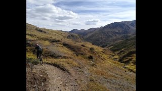
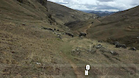
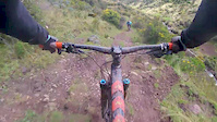
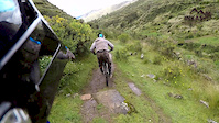
After driving an hour up the canyon from Lamay along a winding dirt road, this picturesque singletrack starts high in Alpaca grazing fields and drops down into a canyon that gives glimpses of rural mountain farm life. Stretches of moderate rolling singletrack are interspersed work technically difficult but fun rock stair drops and tight turns. Herders and farmers share this trail, so the occasional slowdown and “Buenas Dias” is order. You’ll wind past quinoa fields and cut close behind farms as the trail narrows and then widens again into a small uphill section. The last section is a scenic cruise down a quiet gravel road until you reach town.

Access Info

We had Gravity Downhill/Haku guiding us, and they were amazing. Having a guide is recommended to keep good report with the community.

Traditionally Indigenous Territory

Recent Activity on Trail

Past Week
  • 0 rides
  •  
6 Months
  • 0 rides
  •  
All
  • 1 rides
  • Last: May 4, 2025
update trails status or condition

Lamay Trail Reports

Status:
on Jul 12, 2022
Dry
Avg: 3.98 (1 votes)
Your vote: 0

view (9)
close
3D
Trail Conditions
  • Unknown
  • Snow Groomed
  • Snow Packed
  • Snow Covered
  • Snow Cover Partial
  • Freeze/thaw Cycle
  • Icy
  • Prevalent Mud
  • Wet
  • Variable
  • Ideal
  • Dry
  • Very Dry
Trail Flow (Ridden Direction)
Trailforks scans users ridelogs to determine the most popular direction each trail is ridden. A good flowing trail network will have most trails flowing in a single direction according to their intension.
The colour categories are based on what percentage of riders are riding a trail in its intended direction.
  • > 96%
  • > 90%
  • > 80%
  • > 70%
  • > 50%
  • < 50%
  • bi-directional trail
  • no data
Trail Last Ridden
Trailforks scans ridelogs to determine the last time a trail was ridden.
  • < 2 days
  • < 1 week
  • < 2 weeks
  • < 1 month
  • < 6 months
  • > 6 months
Trail Ridden Direction
The intended direction a trail should be ridden.
  • Downhill Only
  • Downhill Primary
  • Both Directions
  • Uphill Primary
  • Uphill Only
  • One Direction
Contribute Details
Colors indicate trail is missing specified detail.
  • Description
  • Photos
  • Description & Photos
  • Videos
Trail Popularity ?
Trailforks scans ridelogs to determine which trails are ridden the most in the last 9 months. Trails are compared with nearby trails in the same city region with a possible 25 colour shades. Think of this as a heatmap, more rides = more kinetic energy = warmer colors.
  • most popular
  • popular
  • less popular
  • not popular
ATV/ORV/OHV Filter
Max Vehicle Width
inches
US Cell Coverage
Legend
cell carrier legend

Radar Time
Activity Recordings
Trailforks uses anonymized public activity data. ?
Activity Recordings
Trailforks uses anonymized public activity data. ?
Personal Heatmap
Activity Types
all / none
Options
2
Date range month
Winter Trails
Warning A routing network for winter maps does not exist. Selecting trails using the winter trails layer has been disabled.
Missing Trails
Most Popular
Least Popular
Trails are colored based on popularity. The more popular a trail is, the more red. Less popular trails trend towards green.
Jump Magnitude Heatmap
Heatmap of where riders jump on trails. Zoom in to see individual jumps, click circles to view jump details.
BC Backroad Status

Service Road Atlas is a free to use, community-driven service for viewing and creating reports on the numerous back-country service roads around B.C. and Alberta.

map legend
Slope Aspect
Direction the slope faces
Flat N NE E SE S SW W NW
Trails Deemphasized
Trails are shown in grey.
disable
Only show trails with no bike usage.
Enable
Suggested Layers
Based on selected activity type

    Save the current map location and zoom level as your default home location whenever this page is loaded.

    Save
        Directions to lamay trailhead (-13.290410, -71.832630)

        Photos

        12 more »
        255 |
        Apr 4, 2016 @ 5:07pm
        Apr 4, 2016
        254 |
        Sep 28, 2017 @ 4:40pm
        Sep 28, 2017
        61 |
        Feb 12, 2020 @ 5:56am
        Feb 12, 2020
        120 |
        Jan 7, 2018 @ 5:42pm
        Jan 7, 2018

        Videos

        7 more »
        MTB Peru - Lamay Sacred Valley
        14:50 | 363 | Sep 25, 2019 , Cusco
        Lamay - Mountain biking Peru
        0:34 | 48 | Dec 26, 2017 , Cusco
        Intibike Flowing at Lamay - Peru!
        2:38 | 88 | May 10, 2017 , Cusco
        Lamay with Inkas Adventures
        5:43 | 75 | Mar 6, 2017 , Cusco

        1 Review & Comments


        We hope you've been enjoying Trailforks!

        Create a FREE account to view trail comments and much more.

        • By KeithestTF Pro & contributors
        • #109896 - 2,268 views

        Frequently Asked Questions About Lamay

        Where is Lamay located?
        Lamay is located in Yuncaypata, Cusco, Peru. It is part of the Yuncaypata trail network. The trailhead is located at coordinates -13.29041, -71.83263.
        How hard is Lamay?
        Lamay is rated as Blue difficulty. The physical rating is Hard. The average grade is 8.309%.
        What is the elevation gain for Lamay?
        Lamay has 425 ft of elevation gain. The trail has 3,804 ft of elevation descent. The elevation ranges from 10,789 ft to 14,214 ft.
        Is Lamay a point to point trail?
        Lamay is not a point to point trail. The direction is Downhill Primary. The trail type is singletrack.

        Hit the Trail

        Open in App

        Get this trail on your phone instantly.
        open trail in app

        Download Trail

        Save to wishlist, Garmin & download.
        save the trail

        Find Related Routes

        Find routes and users activities that include this trail.
        find routes for this trail

        You must enter a description before submitting.