

more stats
9.4 miles
Distance
393 ft
Climb
-4,908 ft
Descent
01:24:15
Avg time
-4,515 ft
Altitude change
10,027 ft
Altitude min
14,552 ft
Altitude max
14,542 ft
Altitude start
10,027 ft
Altitude end
-9.077%
Grade
-54.283%
Grade max
24.541%
Grade min
1 mile
Distance climb
8 miles
Distance down
1,326 ft
Distance flat
01:24:15
Avg time

Lares Pass Details

  • Activities
    • Mountain Bike
    • Hike
    • Trail Running
  • Riding Area
    Cuzco Region
    Cusco
  • Difficulty Rating
  • Global Ranking
    #130531 in Mountain Biking [+]
    • #440615 in Trail Running
    • #445143 in Hiking
  • National Ranking
    #14 in Mountain Biking · Peru [+]
    • #91 in Trail Running
    • #90 in Hiking
  • Trail Type
    Singletrack
  • Bike Type
    DH, AM
  • Season
    Anytime
  • Dogs Allowed
    Yes
  • Ride in Rain
    Yes

Lares Pass:
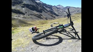
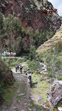
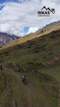
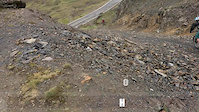
Best trail I was able to ride during my time in Urubamba. You have 5000 feet of descent, starting at 14 600 feet on the Abra Lares and ending in Calca at 9600 feet. It starts with a high mountain feel: short grasses and a lot of black rock. It was also incredibly beautiful, framed by huge snowy mountains battling against the clouds. The terrain is so open that we started by taking no trail, just off roading down steep shale and off camber wet grass. One of my favourite sections of the trip was sliding down into a notch before surfing down a steep grey slope. Afterwords we hit the trail. It was pretty wide but felt like singletrack. There were sections flying along the hillside, through villages. One had ledge sections which popped over to maintain speed. Unreal. To end we got spit into a huge river gorge with cliffs on either side. The rain from yesterday had kept them wet and finding a line was an excellent challnge. Post ride chicha (for my two riding buddies) before ripping back to Calca on side trails.
Accessibility: 8/10. Took transport to Calca and took a car for 25 soles each (8$) to drop us off at the top. Trail required some route finding as it dips off the road.
Level: Intermediate. Off roading at the start expert. Trail intermediate, sections next to the river advanced.
Physical: Shuttled, not too much effort. Need to be acclimatized.
Dirt: Grass and hero dirt up top. Armored trail through villages, rocks through river. To Calca is good dirt. Rideable in wet.
Quality:10/10 Unreal, so dynamic, so many challenges, so much fun
Views:10/10 Surrounded by colossal snowy mountains, diving through llama infested villages, cliff strewn river gorge. Big baller.

Tags

Traditionally Indigenous Territory

Recent Activity on Trail

Past Week
  • 1 rides
  • 21 miles average
6 Months
  • 8 rides
  • 12 miles avg distance
All
  • 31 rides
  • Last: Nov 16, 2026
c1c2c3c4
January
February
March
April
May
June
July
August
September
October
November
December
update trails status or condition

Lares Pass Trail Reports

Status:
on Jul 25, 2022
Dry
Avg: 4.38 (7 votes)
Your vote: 0

view (154)
close
      Directions to lares-pass trailhead (-13.194600, -71.938960)

      Photos

      39 more »
      mtb
      148 |
      Jan 20, 2022 @ 1:18pm
      Jan 20, 2022
      mtb
      140 |
      Jan 20, 2022 @ 1:18pm
      Jan 20, 2022
      mtb
      137 |
      Jan 20, 2022 @ 1:18pm
      Jan 20, 2022
      mtb
      147 |
      Jan 20, 2022 @ 1:18pm
      Jan 20, 2022

      Videos

      6 more »
      MTB Peru - Lares Sacred Valley
      mtb
      11:57 | 376 | Oct 3, 2019 , Cusco
      Epic Rides Sacred Valley of Cusco
      mtb
      0:34 | 20 | Jul 8, 2025 , Cusco
      Lares - Sacred Valley
      mtb
      0:34 | 11 | Jun 24, 2025 , Cusco
      Lares - Mountain biking Peru
      mtb
      2:03 | 108 | Dec 26, 2017 , Cusco
      4.7 ★★★★★
      7 Ratings
      5 ★ 86%
      4 ★
      3 ★ 14%
      2 ★
      1 ★

      5 Reviews & Comments

      jkor jkor
      Awesome! Beautiful views, fun loose shale section to start, lots of llamas, great stuff !!!
      Haku Adventures!
      HakuExpeditions HakuExpeditions
      Lares is a classic must ride trail! A private shuttle will allow you to get there quickly leaving enough time to ride another local trail like Lamay or ankashmarca afterwards.
      perubiking perubiking
      From the Lares Pass, climb up above the small temple and powerlines and unleash an epic Freeride to start your descent. The view gets even better the further up you get!

      We hope you've been enjoying Trailforks!

      Create a FREE account to view all trail reviews and much more.

      • By dannyTF Pro & contributors
      • #7944 - 3,875 views

      Frequently Asked Questions

      ▼ Where is Lares Pass located?
      Lares Pass is located in Cuzco Region, Cusco, Peru. It is part of the Cuzco Region trail network. The trailhead is located at coordinates -13.1946, -71.93896.
      ▼ How hard is Lares Pass?
      Lares Pass is rated as Blue difficulty. The average grade is 9.077%.
      ▼ What is the elevation gain for Lares Pass?
      Lares Pass has 393 ft of elevation gain. The trail has 4,908 ft of elevation descent. The elevation ranges from 10,027 ft to 14,552 ft.
      ▼ How long is Lares Pass?
      Lares Pass is 9.4 miles long. The trail type is singletrack.
      ▼ Are dogs allowed on Lares Pass?
      Yes, dogs are allowed on Lares Pass. Please keep dogs on a leash where required and clean up after them.
      ▼ When is the best time of year to ride Lares Pass?
      Based on activity log data, the most popular months to ride Lares Pass are:
      • November (5 activities)
      • July (4 activities)
      • September (3 activities)
      Check the reports page for current trail conditions.
      ▼ How long does it take to ride Lares Pass?
      Based on recorded activities, it takes an average of 1 hour 24 minutes to ride Lares Pass. The trail is 9.4 miles long. Actual times will vary based on fitness level, conditions, and pace. View recent activity logs for more details.
      ▼ How busy is Lares Pass?
      Lares Pass has limited popularity data available. There have been 157 recorded activities on this trail. The trail has received 154 check-ins. View recent activity on this trail.

      Hit the Trail

      Open in App

      Get this trail on your phone instantly.

      open trail in app

      Download Trail

      Save to wishlist, Garmin & download.
      save the trail

      Find Related Routes

      Find routes and users activities that include this trail.
      find routes for this trail

      You must enter a description before submitting.

