1,801 ft
Distance
15 ft
Climb
-24 ft
Descent
00:04:32
Avg time
Limestone Loop Details
-
Activities
- Mountain Bike
-
Riding AreaI5-Colonnade
Seattle, Washington -
Difficulty Rating
-
Trail TypeSingletrack
-
Bike TypeXC
-
DirectionBoth Directions
-
Climb DifficultyBlue
-
Physical RatingEasy
-
Trail VisibilityAlways easy to follow
-
Dogs AllowedYes
-
TTFs on TrailA-Frame, Berm, Bridge, Drop, Ladder Bridge, Log Ride, Rock Face, Rock Garden, Skinny, Other
-
Global Ranking#145005 in Mountain Biking
-
Local Popularity65 in Mountain Biking
-
Year Opened2007
-
Land OwnerSeattle Parks & Rec
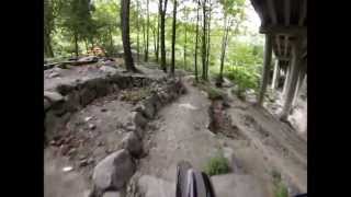
Limestone Loop is a 1/2-mile tight & twisty XC loop with dozens of optional skinnies, drops, rock chutes, rock steps, and other features. Several hundred tons of limestone rocks and boulders were used to make retaining walls for the terraced layout of the trail.
Local Trail Association
-
Please consider joining or donating to the local trail association to supportdonate to earn trail karma!
trail development & maintenance.
Traditionally Indigenous Territory
More Stats for Limestone Loop mountain bike trail trail
-
Altitude change-9 ft
-
Altitude min122 ft
-
Altitude max148 ft
-
Altitude start131 ft
-
Altitude end121 ft
-
Grade-0.5%
-
Grade max-7.8%
-
Grade min6.2%
-
Distance climb381 ft
-
Distance down699 ft
-
Distance flat722 ft
-
Avg time00:04:32
-
Avg reverse time00:06:46
- view trail stats
close
3D
Trail Conditions
- Unknown
- Snow Groomed
- Snow Packed
- Snow Covered
- Snow Cover Partial
- Freeze/thaw Cycle
- Icy
- Prevalent Mud
- Wet
- Variable
- Ideal
- Dry
- Very Dry
Trail Flow (Ridden Direction)
Trailforks scans users ridelogs to determine the most popular direction each trail is ridden. A good flowing trail network will have most trails flowing in a single direction according to their intension.
The colour categories are based on what percentage of riders are riding a trail in its intended direction.
- > 96%
- > 90%
- > 80%
- > 70%
- > 50%
- < 50%
- bi-directional trail
- no data
Trail Last Ridden
Trailforks scans ridelogs to determine the last time a trail was ridden.
- < 2 days
- < 1 week
- < 2 weeks
- < 1 month
- < 6 months
- > 6 months
Trail Ridden Direction
The intended direction a trail should be ridden.
- Downhill Only
- Downhill Primary
- Both Directions
- Uphill Primary
- Uphill Only
- One Direction
Contribute Details
Colors indicate trail is missing specified detail.
- Description
- Photos
- Description & Photos
- Videos
Trail Popularity ?
Trailforks scans ridelogs to determine which trails are ridden the most in the last 9 months.
Trails are compared with nearby trails in the same city region with a possible 25 colour shades.
Think of this as a heatmap, more rides = more kinetic energy = warmer colors.
- most popular
- popular
- less popular
- not popular
ATV/ORV/OHV Filter
Max Vehicle Width
inches
US Cell Coverage
Legend
Radar Time
x
Activity Recordings
Trailforks users anonymized public ridelogs from the past 6 months.
- mountain biking recent
- mountain biking (>6 month)
- hiking (1 year)
- moto (1 year)
Activity Recordings
Trailforks users anonymized public skilogs from the past 12 months.
- Downhill Ski
- Backcountry Ski
- Nordic Ski
- Snowmobile
Winter Trails
Warning
A routing network for winter maps does not exist. Selecting trails using the winter trails layer has been disabled.
x
Missing Trails
Most Popular
Least Popular
Trails are colored based on popularity. The more popular a trail is, the more red. Less popular trails trend towards green.
Jump Magnitude Heatmap
Heatmap of where riders jump on trails. Zoom in to see individual jumps, click circles to view jump details.
Trails Deemphasized
Trails are shown in grey.
Only show trails with NO bikes.
Save the current map location and zoom level as your default home location whenever this page is loaded.
Save
Directions to limestone-loop trailhead
(47.634830, -122.323130)
update trails status or condition
Limestone Loop Trail Reports
view all reports »
Recent Ridelog Activity on Trail
Past Week
- 0 rides
6 Months
- 1 rides
- 7 miles avg distance
All
- 6 rides
- Last: May 8, 2025
Photos
more »
Trail Products
We hope you've been enjoying Trailforks!
Create a FREE account to view trail comments and much more.
Nearby Trails
- Tqalu East 105 ft
- Sidewinder Trail 246 ft
- K-line 246 ft
- High Life Line 246 ft
- The Ogie 249 ft
- By I5-Troll
EMBA EMBA-Staff EMBA-C2S & contributors
- #353276 - 1,159 views
- follow/subscribe
- login to download gpx or kml files.
You must enter a description before submitting.