1.6 miles
Distance
45 ft
Climb
-305 ft
Descent
00:08:26
Avg time

Śliwa Details

  • Activities
    • Mountain Bike
    • Hike
    • Trail Running
  • Riding Area
    Puszcza Bukowa
    Szczecin
  • AKA
    Śliwka węgierka, sliwka wegierka
  • Difficulty Rating
  • Voted Difficulty
    Red (2 votes)
  • Trail Type
    Singletrack
  • Bike Type
    AM, XC
  • Direction
    Downhill Primary
    Popular direction shown
  • Climb Difficulty
    Black Diamond
  • Physical Rating
    Hard
  • Trail Visibility
    Sometimes hard to follow
  • Dogs Allowed
    Yes
  • TTFs on Trail
    Drop, Other
  • Global Ranking
    #77175 in Mountain Biking [+]
    • #70062 in Trail Running
    • #33653 in Hiking
  • Local Popularity
    70 in Mountain Biking [+]
    • 5 in Trail Running
    • 65 in Hiking
  • Year Opened
    2019

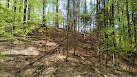
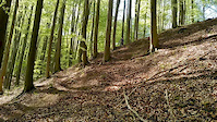
Dosyć mocno interwałowa trasa typu Trail, po odnowieniu zyskała nieco blasku. Trochę zmieniony koniec trasy jest na duży plus. Ogólnie niby w dół, a można się zmęczyć

This trail is unsanctioned.

More Stats for Śliwa mountain bike trail trail
  • Altitude change
    -262 ft
  • Altitude min
    230 ft
  • Altitude max
    492 ft
  • Altitude start
    492 ft
  • Altitude end
    230 ft
  • Grade
    -3.2%
  • Grade max
    -21.2%
  • Grade min
    9%
  • Distance climb
    1,732 ft
  • Distance down
    5,062 ft
  • Distance flat
    1,407 ft
  • Avg time
    00:08:26
  • Avg reverse time
    00:03:38
  • view trail stats
Status:
on Aug 25, 2024
Dry
Avg: 3.68 (7 votes)
Your vote: 0

view (586)
close
3D
Trail Conditions
  • Unknown
  • Snow Groomed
  • Snow Packed
  • Snow Covered
  • Snow Cover Partial
  • Freeze/thaw Cycle
  • Icy
  • Prevalent Mud
  • Wet
  • Variable
  • Ideal
  • Dry
  • Very Dry
Trail Flow (Ridden Direction)
Trailforks scans users ridelogs to determine the most popular direction each trail is ridden. A good flowing trail network will have most trails flowing in a single direction according to their intension.
The colour categories are based on what percentage of riders are riding a trail in its intended direction.
  • > 96%
  • > 90%
  • > 80%
  • > 70%
  • > 50%
  • < 50%
  • bi-directional trail
  • no data
Trail Last Ridden
Trailforks scans ridelogs to determine the last time a trail was ridden.
  • < 2 days
  • < 1 week
  • < 2 weeks
  • < 1 month
  • < 6 months
  • > 6 months
Trail Ridden Direction
The intended direction a trail should be ridden.
  • Downhill Only
  • Downhill Primary
  • Both Directions
  • Uphill Primary
  • Uphill Only
  • One Direction
Contribute Details
Colors indicate trail is missing specified detail.
  • Description
  • Photos
  • Description & Photos
  • Videos
Trail Popularity ?
Trailforks scans ridelogs to determine which trails are ridden the most in the last 9 months. Trails are compared with nearby trails in the same city region with a possible 25 colour shades. Think of this as a heatmap, more rides = more kinetic energy = warmer colors.
  • most popular
  • popular
  • less popular
  • not popular
ATV/ORV/OHV Filter
Max Vehicle Width
inches
US Cell Coverage
Legend
cell carrier legend

Radar Time
x Activity Recordings
Trailforks users anonymized public ridelogs from the past 6 months.
  • mountain biking recent
  • mountain biking (>6 month)
  • hiking (1 year)
  • moto (1 year)
Activity Recordings
Trailforks users anonymized public skilogs from the past 12 months.
  • Downhill Ski
  • Backcountry Ski
  • Nordic Ski
  • Snowmobile
Winter Trails
Warning A routing network for winter maps does not exist. Selecting trails using the winter trails layer has been disabled.
x Missing Trails
Most Popular
Least Popular
Trails are colored based on popularity. The more popular a trail is, the more red. Less popular trails trend towards green.
Jump Magnitude Heatmap
Heatmap of where riders jump on trails. Zoom in to see individual jumps, click circles to view jump details.
Trails Deemphasized
Trails are shown in grey.
disable
Only show trails with NO bikes.
enable

Save the current map location and zoom level as your default home location whenever this page is loaded.

Save
      Directions to liwa trailhead (53.333430, 14.677220)
      update trails status or condition

      Śliwa Trail Reports

      statusdatedescription
      Aug 25, 2024 @ 2:22pm
      Aug 25, 2024
      Jul 30, 2024 @ 11:44pm
      Jul 30, 2024
      Jul 27, 2024 @ 10:12am
      Jul 27, 2024
      May 9, 2024 @ 5:14am
      May 9, 2024
      Jak w raporcie poniżej
      May 7, 2024 @ 2:05pm
      May 7, 2024
      Pierwsza ścianka już ok. W pierwszej części jedno drzewko. W drugiej części troche badyli i liści, ale ogolnie da sie lecieć
      view all reports »

      Recent Ridelog Activity on Trail

      Past Week
      • 0 rides
      •  
      6 Months
      • 1 rides
      • 21 miles avg distance
      All
      • 95 rides
      • Last: Mar 15, 2025

      Photos

      more »
      25 |
      Apr 15, 2022 @ 11:17pm
      Apr 15, 2022
      28 |
      Apr 15, 2022 @ 11:17pm
      Apr 15, 2022
      43 |
      Apr 15, 2022 @ 11:17pm
      Apr 15, 2022
      82 |
      Jun 21, 2020 @ 11:54am
      Jun 21, 2020

      8 Reviews & Comments


      We hope you've been enjoying Trailforks!

      Create a FREE account to view trail comments and much more.

      Videos

      more »
      Pussy trail na końcu Sliwy
      0:09 | 325 | Apr 26, 2019 , Szczecin
      Ścianka na końcu Sliwy
      0:13 | 299 | Apr 26, 2019 , Szczecin
      • #177734 - 3,881 views

      You must enter a description before submitting.