






more stats
3,150 ft
Distance
-339 ft
Descent
00:09:39
Avg time
-340 ft
Altitude change
1,993 ft
Altitude min
2,333 ft
Altitude max
2,333 ft
Altitude start
1,995 ft
Altitude end
-10.8%
Grade
-27%
Grade max
3,002 ft
Distance down
148 ft
Distance flat
00:09:39
Avg time

Lo Dragonet Details

  • Activities
    • Mountain Bike
    • E-Bike
    • Hike
    • Trail Running
  • Riding Area
  • Difficulty Rating
  • Voted Difficulty
    Red (2 votes)
  • Local Popularity
    85 in Mountain Biking heatmap [+]
    • 85 in E-Biking
    • 65 in Trail Running
    • 80 in Hiking
  • Global Ranking
    #343 in Mountain Biking [+]
    • #23784 in E-Biking
    • #139982 in Trail Running
    • #125746 in Hiking
  • National Ranking
    #12 in Mountain Biking · Spain [+]
    • #2,077 in E-Biking
    • #11,657 in Trail Running
    • #8,743 in Hiking
  • Trail Type
    Singletrack
  • Bike Type
    AM, XC
  • Direction
    Downhill Only
    Popular Direction Shown
  • Physical Rating
    Easy
  • Trail Visibility
    Always easy to follow
  • Dogs Allowed
    Yes
  • eBike Allowed
    Yes up to Class 1
  • TTFs on Trail
    Berm, Bridge, Drop, Jump, Wallride
  • Year Opened
    2024

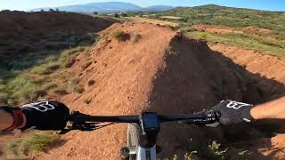
Variant del Dragon Khan. Traçat paral.lel amb menys dificultat. Itinerari variat amb wallrides al principi, algun pas estret i tobogans. La part final surt del terreny argilós amb trams ràpids i canvis de rasant. Terreny argilós, no passar en dies de fang!

Esp: Variante del Dragon Khan. Trazado paralelo con menor dificultad. Itinerario variado con wallrides en la parte inicial, algun paso estrecho y toboganes. La parte final sale del terreno arcilloso con tramos rápidos y cambios de rasante.Terreno arcilloso, no pasar en dias de barro!!

Tags
BermsBridgesDropsJumpsWallride

Trail Supporters

Local Trail Association

Recent Activity on Trail

Past Week
  • 8 rides
  • 24 miles average
6 Months
  • 38 rides
  • 21 miles avg distance
All
  • 123 rides
  • Last: Nov 10, 2026
c1c2c3c4
January
February
March
April
May
June
July
August
September
October
November
December
Status:
on Oct 13, 2026
Ideal
Avg: 4.7 (16 votes)
Your vote: 0

view (564)
close
      Directions to lo-dragonet trailhead (42.202000, 0.865270)

      Photos

      13 more »
      mtb
      54 |
      Sep 18, 2026 @ 5:20am
      Sep 18, 2026
      mtb
      84 |
      May 26, 2026 @ 3:49am
      May 26, 2026
      mtb
      38 |
      May 17, 2026 @ 11:38am
      May 17, 2026
      mtb
      44 |
      May 17, 2026 @ 11:38am
      May 17, 2026

      Videos

      4 more »
      THE TINY DRAGON WARM-UP, Spain, Tremp, Lo...
      mtb
      3:18 | 74 | May 21, 2026 , Tremp
      A Heart-Pounding Blind Run Down Lo Dragonet...
      mtb
      0:43 | 297 | Dec 10, 2024 , Tremp
      Lo Dragonet 4k
      mtb
      3:17 | 336 | Oct 21, 2024 , Tremp
      Lo Dragonet by Territori Lo Podall
      mtb
      3:30 | 277 | Jul 28, 2024 , Tremp

      Routes with this trail

      more »
      15 miles • 2,624 ft • 10 • Loop •
      Ruta que passa pel DRAGON KHAN i el DRAGONET entre d'altres.Molt flow i poca pedra. Terreny argilós el...
      5.0 ★★★★★
      16 Ratings
      5 ★ 100%
      4 ★
      3 ★
      2 ★
      1 ★

      5 Reviews & Comments

      green-tee green-tee
      Que bien! A lot easier than the Khan, I‘d recon. Just two small parts where its narrow but duable.
      elyari elyari
      Muy chula y divertida. La erosión de las últimas lluvias ha causado algunas roderas en plena trazada, cuidado.
      britanishskiy britanishskiy
      Great trail! Pure red and really similar to the big Dragon in a few places

      We hope you've been enjoying Trailforks!

      Create a FREE account to view all trail reviews and much more.

      Frequently Asked Questions

      ▼ Where is Lo Dragonet located?
      Lo Dragonet is located in Territori Lo Podall Tremp, Tremp, Spain. It is part of the Territori Lo Podall Tremp trail network. The trailhead is located at coordinates 42.202, 0.86527.
      ▼ How hard is Lo Dragonet?
      Lo Dragonet is rated as Red difficulty. The physical rating is Easy. The average grade is 10.8%.
      ▼ What is the elevation gain for Lo Dragonet?
      The trail has 339 ft of elevation descent. The elevation ranges from 1,993 ft to 2,333 ft.
      ▼ Is Lo Dragonet a point to point trail?
      Yes, Lo Dragonet is a point to point trail. The direction is Downhill Only. The trail type is singletrack.
      ▼ How long is Lo Dragonet?
      Lo Dragonet is 3,150 ft long. The trail type is singletrack.
      ▼ Are dogs allowed on Lo Dragonet?
      Yes, dogs are allowed on Lo Dragonet. Please keep dogs on a leash where required and clean up after them.
      ▼ When is the best time of year to ride Lo Dragonet?
      Based on activity log data, the most popular months to ride Lo Dragonet are:
      • May (24 activities)
      • April (15 activities)
      • October (15 activities)
      Check the reports page for current trail conditions.
      ▼ How do I access Lo Dragonet? Where is the closest parking trailhead?
      The closest parking and trailhead locations to Lo Dragonet are: View all parking locations in the area.
      ▼ How long does it take to ride Lo Dragonet?
      Based on recorded activities, it takes an average of 10 minutes to ride Lo Dragonet. The trail is 3,150 ft long. Actual times will vary based on fitness level, conditions, and pace. View recent activity logs for more details.
      ▼ How busy is Lo Dragonet?
      Lo Dragonet is a very popular trail. There have been 531 recorded activities on this trail. The trail has received 564 check-ins. View recent activity on this trail.

      Hit the Trail

      Open in App

      Get this trail on your phone instantly.

      open trail in app

      Download Trail

      Save to wishlist, Garmin & download.
      save the trail

      Find Related Routes

      Find routes and users activities that include this trail.
      find routes for this trail

      You must enter a description before submitting.

