more stats
1,191 ft
Distance
2 ft
Climb
-214 ft
Descent
1 mile
High Point
-212 ft
Altitude change
5,167 ft
Altitude min
5,381 ft
Altitude start
5,171 ft
Altitude end
-17.8%
Grade
-41.8%
Grade max
3.2%
Grade min
164 ft
Distance climb
961 ft
Distance down
69 ft
Distance flat

Loamonade Details

  • Activities
    • Mountain Bike
    • E-Bike
  • Riding Area
    Whistler Mountain Bike Park
    Whistler, British Columbia
  • Difficulty Rating
  • Voted Difficulty
    Blue (3 votes)
  • Local Popularity
    50 in Mountain Biking [+]
    • 55 in E-Biking
  • Global Ranking
    #31547 in Mountain Biking [+]
    • #65893 in E-Biking
  • Trail Type
    Singletrack
  • Direction
    Downhill Only
    Popular Direction Shown
  • Trail Visibility
    Always easy to follow
  • Season
    Spring, Summer, Fall
  • eBike Allowed
    Yes up to Class 1
  • Year Opened
    2024

No community description for Loamonade trail has been added yet!

AI Generated Description

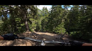
Loamonade is a highly rated 363 m moderately popular black diamond difficulty singletrack trail located near Whistler British Columbia. This mountain bike primary trail can be used downhill only. Trail visibility is always easy to follow.

Access Info

Turn right at the end of Lemon Peel before you merge into Original Sin.

Disclaimer

Trail is a part of the Whistler Bike Park. Contact patrol at +16049355555

Bike Park

Recent Activity on Trail

Past Week
  • 29 rides
  • 24 miles average
6 Months
  • 142 rides
  • 25 miles avg distance
All
  • 502 rides
  • Last: Jul 4, 2026
c1c2c3c4
January
February
March
April
May
June
July
August
September
October
November
December
update trails status or condition

Loamonade Trail Reports

statusdatedescription
Jun 14, 2026 @ 11:57am (America/Vancouver)
Jun 14, 2026
reporter
Oct 18, 2025 @ 11:49pm (America/Vancouver)
Oct 18, 2025
Closed for the season, see you in 2026
Sep 15, 2025 @ 12:06pm (America/Vancouver)
Sep 15, 2025
reporter
Sep 2, 2025 @ 3:01pm
Sep 2, 2025
Not much loam left in this loamonade.
Aug 22, 2025 @ 4:34pm
Aug 22, 2025
reporter
massive rework to the wet corner before the rock roll. we did a reroute along with some nice tune ups. Enjoy
more »
Status:
on Jun 14, 2026
Ideal
Avg: 4.46 (10 votes)
Your vote: 0

view (2,347)
close
3D
Trail Conditions
  • Unknown
  • Snow Groomed
  • Snow Packed
  • Snow Covered
  • Snow Cover Partial
  • Freeze/thaw Cycle
  • Icy
  • Prevalent Mud
  • Wet
  • Variable
  • Ideal
  • Dry
  • Very Dry
Trail Flow (Ridden Direction)
Trailforks scans users ridelogs to determine the most popular direction each trail is ridden. A good flowing trail network will have most trails flowing in a single direction according to their intension.
The colour categories are based on what percentage of riders are riding a trail in its intended direction.
  • > 96%
  • > 90%
  • > 80%
  • > 70%
  • > 50%
  • < 50%
  • bi-directional trail
  • no data
Trail Last Ridden
Trailforks scans ridelogs to determine the last time a trail was ridden.
  • < 2 days
  • < 1 week
  • < 2 weeks
  • < 1 month
  • < 6 months
  • > 6 months
Trail Ridden Direction
The intended direction a trail should be ridden.
  • Downhill Only
  • Downhill Primary
  • Both Directions
  • Uphill Primary
  • Uphill Only
  • One Direction
Contribute Details
Colors indicate trail is missing specified detail.
  • Description
  • Photos
  • Description & Photos
  • Videos
Trail Popularity ?
Trailforks scans ridelogs to determine which trails are ridden the most in the last 9 months. Trails are compared with nearby trails in the same city region with a possible 25 colour shades. Think of this as a heatmap, more rides = more kinetic energy = warmer colors.
  • most popular
  • popular
  • less popular
  • not popular
ATV/ORV/OHV Filter
Max Vehicle Width
inches
US Cell Coverage
Legend
cell carrier legend

Radar Time
Activity Recordings
Trailforks uses anonymized public activity data. ?
Activity Recordings
Trailforks uses anonymized public activity data. ?
Personal Heatmap
Activity Types
all / none
Options
2
Date range month
Winter Trails
Warning A routing network for winter maps does not exist. Selecting trails using the winter trails layer has been disabled.
Missing Trails
Most Popular
Least Popular
Trails are colored based on popularity. The more popular a trail is, the more red. Less popular trails trend towards green.
Jump Magnitude Heatmap
Heatmap of where riders jump on trails. Zoom in to see individual jumps, click circles to view jump details.
BC Backroad Status

Service Road Atlas is a free to use, community-driven service for viewing and creating reports on the numerous back-country service roads around B.C. and Alberta.

map legend
Slope Aspect
Direction the slope faces
Flat N NE E SE S SW W NW
Trails Deemphasized
Trails are shown in grey.
disable
Only show trails with no bike usage.
Enable
Suggested Layers
Based on selected activity type

    Save the current map location and zoom level as your default home location whenever this page is loaded.

    Save
        Directions to loamonade trailhead (50.078710, -122.953970)

        Photos

        0 more »
        49 |
        Aug 22, 2025 @ 4:34pm
        Aug 22, 2025
        53 |
        Sep 16, 2024 @ 12:10pm
        Sep 16, 2024
        61 |
        Aug 4, 2024 @ 4:58pm
        Aug 4, 2024

        Videos

        5 more »
        youtuber New Trail in WHISTLER BIKE PARK | LOAMONADE |...
        0:04 | 122 | Aug 6, 2024 , Whistler
        youtuber LOAMONADE | Single Black trail | WHISTLER Bike...
        0:46 | 163 | Aug 30, 2024 , Whistler
        youtuber Loamanade - Whistler Bike Park  | LINES
        0:56 | 187 | Jul 2, 2025 , Whistler
        Whistler with the Boys - Whistler Mountain...
        10:08 | 91 | Sep 1, 2024 , Whistler

        Routes with this trail

        20 miles 8,531 ft 22

        3 Reviews & Comments


        We hope you've been enjoying Trailforks!

        Create a FREE account to view trail comments and much more.

        • By asur90TF Pro WBPP & contributors
        • #773542 - 1,171 views

        Frequently Asked Questions About Loamonade

        Where is Loamonade located?
        Loamonade is located in Whistler Mountain Bike Park, Whistler, British Columbia, Canada. It is part of the Whistler Mountain Bike Park trail network. The trailhead is located at coordinates 50.07871, -122.95397.
        How hard is Loamonade?
        Loamonade is rated as Black Diamond difficulty. The average grade is 17.8%.
        What is the elevation gain for Loamonade?
        Loamonade has 2 ft of elevation gain. The trail has 214 ft of elevation descent. The elevation ranges from 5,167 ft to 5,381 ft.
        Is Loamonade a point to point trail?
        Yes, Loamonade is a point to point trail. The direction is Downhill Only. The trail type is singletrack.

        Hit the Trail

        Open in App

        Get this trail on your phone instantly.
        open trail in app

        Download Trail

        Save to wishlist, Garmin & download.
        save the trail

        Find Related Routes

        Find routes and users activities that include this trail.
        find routes for this trail

        You must enter a description before submitting.