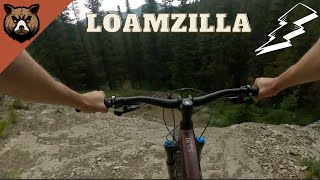
more stats
1.6 miles
Distance
-1,202 ft
Descent
00:14:25
Avg time
-1,202 ft
Altitude change
5,044 ft
Altitude min
6,246 ft
Altitude max
6,246 ft
Altitude start
5,043 ft
Altitude end
-14.5%
Grade
-53.2%
Grade max
0.6%
Grade min
2 miles
Distance down
184 ft
Distance flat
00:14:25
Avg time

Loamzilla Details

  • Activities
    • Mountain Bike
    • E-Bike
  • Riding Area
    Prairie Mountain
    Bragg Creek, Alberta
  • Difficulty Rating
  • Voted Difficulty
    Black Diamond (5 votes)
  • Local Popularity
    90 in Mountain Biking [+]
    • 100 in E-Biking
  • Global Ranking
    #22247 in Mountain Biking [+]
    • #6810 in E-Biking
  • Trail Type
    Singletrack
  • Bike Type
    AM
  • Direction
    Downhill Only
    Popular Direction Shown
  • Physical Rating
    Moderate
  • Trail Visibility
    Always easy to follow
  • Dogs Allowed
    Yes
  • eBike Allowed
    Yes up to Class 1
  • TTFs on Trail
    Rock Face
  • Land Owner
    AE+P

Natural singletrack trail winding through forest. Similar terrain to Pistolero but with steeper sections. The main feature is a rocky outcrop to very loose left-hand catch berm. There is now a ride-around for the rock roll.

Access Info

Access from the top is off of the Husky Road, the trail exits onto Elbow Valley.

Recent Activity on Trail

Past Week
  • 13 rides
  • 24.1 km average
6 Months
  • 92 rides
  • 19.1 km avg distance
All
  • 709 rides
  • Last: Jun 15, 2026
c1c2c3c4
January
February
March
April
May
June
July
August
September
October
November
December
Status:
on May 26, 2026
Ideal
Avg: 4.1 (27 votes)
Your vote: 0

view (5,494)
close
3D
Trail Conditions
  • Unknown
  • Snow Groomed
  • Snow Packed
  • Snow Covered
  • Snow Cover Partial
  • Freeze/thaw Cycle
  • Icy
  • Prevalent Mud
  • Wet
  • Variable
  • Ideal
  • Dry
  • Very Dry
Trail Flow (Ridden Direction)
Trailforks scans users ridelogs to determine the most popular direction each trail is ridden. A good flowing trail network will have most trails flowing in a single direction according to their intension.
The colour categories are based on what percentage of riders are riding a trail in its intended direction.
  • > 96%
  • > 90%
  • > 80%
  • > 70%
  • > 50%
  • < 50%
  • bi-directional trail
  • no data
Trail Last Ridden
Trailforks scans ridelogs to determine the last time a trail was ridden.
  • < 2 days
  • < 1 week
  • < 2 weeks
  • < 1 month
  • < 6 months
  • > 6 months
Trail Ridden Direction
The intended direction a trail should be ridden.
  • Downhill Only
  • Downhill Primary
  • Both Directions
  • Uphill Primary
  • Uphill Only
  • One Direction
Contribute Details
Colors indicate trail is missing specified detail.
  • Description
  • Photos
  • Description & Photos
  • Videos
Trail Popularity ?
Trailforks scans ridelogs to determine which trails are ridden the most in the last 9 months. Trails are compared with nearby trails in the same city region with a possible 25 colour shades. Think of this as a heatmap, more rides = more kinetic energy = warmer colors.
  • most popular
  • popular
  • less popular
  • not popular
ATV/ORV/OHV Filter
Max Vehicle Width
inches
US Cell Coverage
Legend
cell carrier legend

Radar Time
Activity Recordings
Trailforks uses anonymized public activity data. ?
Activity Recordings
Trailforks uses anonymized public activity data. ?
Personal Heatmap
Activity Types
all / none
Options
2
Date range month
Winter Trails
Warning A routing network for winter maps does not exist. Selecting trails using the winter trails layer has been disabled.
Missing Trails
Most Popular
Least Popular
Trails are colored based on popularity. The more popular a trail is, the more red. Less popular trails trend towards green.
Jump Magnitude Heatmap
Heatmap of where riders jump on trails. Zoom in to see individual jumps, click circles to view jump details.
BC Backroad Status

Service Road Atlas is a free to use, community-driven service for viewing and creating reports on the numerous back-country service roads around B.C. and Alberta.

map legend
Slope Aspect
Direction the slope faces
Flat N NE E SE S SW W NW
Trails Deemphasized
Trails are shown in grey.
disable
Only show trails with no bike usage.
Enable
Suggested Layers
Based on selected activity type

    Save the current map location and zoom level as your default home location whenever this page is loaded.

    Save
        Directions to loamzilla trailhead (50.889270, -114.782230)

        Photos

        9 more »
        215 |
        Jul 25, 2023 @ 12:28pm
        Jul 25, 2023
        522 |
        Jul 10, 2023 @ 7:16pm
        Jul 10, 2023
        328 |
        Sep 11, 2022 @ 9:10pm
        Sep 11, 2022
        360 |
        Aug 5, 2022 @ 11:59am
        Aug 5, 2022

        Videos

        8 more »
        youtuber Mooseduro 2025 | Moose Mountain, AB
        23:10 | 75 | Jan 3, 2026 , Bragg Creek
        youtuber Riding Loamzilla in a Thunderstorm | Not a...
        8:58 | 342 | Sep 7, 2024 , Bragg Creek
        Loamzilla Trail
        10:50 | 631 | Jun 5, 2023 , Bragg Creek
        Loamzilla [Prairie Mountain]
        11:29 | 252 | May 22, 2023 , Bragg Creek

        Routes with this trail

        5.0 6 miles 1,477 ft 3 Loop
        - Take the Husky Road up through Road to Gondor - Keep left through all the way down to Elbow Valley - At...
        16 miles 4,138 ft 6
        Both lines on are in.
        11 miles 2,763 ft 5 Loop
        Using Husky Road to do two of the easier downhills

        8 Reviews & Comments


        We hope you've been enjoying Trailforks!

        Create a FREE account to view trail comments and much more.

        • By pinkrobe & contributors
        • #93892 - 9,435 views

        Frequently Asked Questions About Loamzilla

        Where is Loamzilla located?
        Loamzilla is located in Prairie Mountain, Bragg Creek, Alberta, Canada. It is part of the Prairie Mountain trail network. The trailhead is located at coordinates 50.88927, -114.78223.
        How hard is Loamzilla?
        Loamzilla is rated as Black Diamond difficulty. The physical rating is Moderate. The average grade is 14.5%.
        What is the elevation gain for Loamzilla?
        The trail has 1,202 ft of elevation descent. The elevation ranges from 5,044 ft to 6,246 ft.
        Is Loamzilla a point to point trail?
        Yes, Loamzilla is a point to point trail. The direction is Downhill Only. The trail type is singletrack.

        Hit the Trail

        Open in App

        Get this trail on your phone instantly.
        open trail in app

        Download Trail

        Save to wishlist, Garmin & download.
        save the trail

        Find Related Routes

        Find routes and users activities that include this trail.
        find routes for this trail

        You must enter a description before submitting.