more stats
1.3 miles
Distance
8 ft
Climb
-1,122 ft
Descent
00:18:04
Avg time
-1,114 ft
Altitude change
4,094 ft
Altitude min
5,217 ft
Altitude max
5,208 ft
Altitude start
4,094 ft
Altitude end
-16.2%
Grade
-71.6%
Grade max
6.5%
Grade min
554 ft
Distance climb
1 mile
Distance down
138 ft
Distance flat
00:18:04
Avg time

LSD Details

  • Activities
    • Mountain Bike
    • E-Bike
  • Riding Area
    Moonrakers
    Golden, British Columbia
  • Difficulty Rating
  • Voted Difficulty
    Black Diamond (2 votes)
  • Local Popularity
    45 in Mountain Biking [+]
    • 55 in E-Biking
  • Global Ranking
    #50213 in Mountain Biking [+]
    • #80307 in E-Biking
  • Trail Type
    Singletrack
  • Bike Type
    AM, XC
  • Dogs Allowed
    Yes
  • eBike Allowed
  • TTFs on Trail
    A-Frame, Bridge, Drop, Log Ride, Skinny

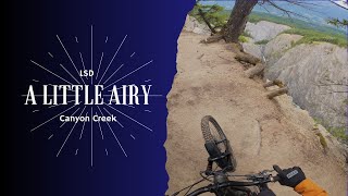
Like the peak across the valley from which this trail takes its name, Little Sir Donald (LSD) is steep, long and stunning. Not so subtly, the name also testifies to the wild and crazy nature of this trail.

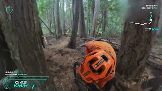
Expect arches, skinnies, log rides, steeper sections with medium drops, a ladder drop and rock slab. As you descend LSD through stunning cedar forest, you’ll find loamy goodness intertwined with all these technical trail features. Features and stunts should be scouted prior to riding them for the first time. Wet wood is not good Beware of slippery features when damp. Some drops are up to six feet. Most features have some sort of ride around if you look for it. The trail joins in to Canyon Creek trail for more fast flow all the way back into the Moonrakers.

Dropping into the mid-way entrance of LSD at km 6.8 skips some of the steeps, but not all of them. From the midway entrance, the trailhead marking the true upper start of LSD can be found 1.7km further up the road at the south end of a small cut block. Follow the that trail towards the edge of the canyon, finding stunning views on your right. Don’t get too close.

Access Info

From Cedar Lake Trailhead follow the road south (left). On your right is a sign indicating 8.5km to LSD. Directions from this sign are given here, but in general stay on the main road for 3.7km before turning up right and continuing for another 4.8km.
From the 8.5km sign:
0.4 km the entrance to North Star is on your left, stay on the main road
1.5 km don’t go left, stay straight on the main road
2.0 km don’t go left or right, but stay straight on main road (a yellow 4km Forest Service Road marker is visible)
2.2 km don’t go left, stay straight on the main road
3.2 km don’t go right or left, but stay straight on the main road
3.7 km don’t go left, but instead turn up right off the main road
4.8km signed entrance for Canyon Creek trail
6.8km signed entrance for LSD mid-way point
8.5km signed entrance for LSD. This sign often goes missing; look for the singletrack on the south side of the cut block.

Local Trail Association
Traditionally Indigenous Territory

Recent Activity on Trail

Past Week
  • 0 rides
  •  
6 Months
  • 2 rides
  • 8 miles avg distance
All
  • 180 rides
  • Last: May 23, 2026
c1c2c3c4
January
February
March
April
May
June
July
August
September
October
November
December
update trails status or condition

LSD Trail Reports

statusdatedescription
May 11, 2026 @ 7:11pm (America/Edmonton)
May 11, 2026
reporter
Mar 30, 2026 @ 7:56pm (America/Edmonton)
Mar 30, 2026
reporter The trail crew will open trails as they are assessed. Thanks.
May 9, 2025 @ 3:53pm
May 9, 2025
reporter
Mar 12, 2025 @ 12:21pm
Mar 12, 2025
reporter Even though it feels like the start of the riding season the trails are still not good to go. Even the sunny slopes have sections with snow and...
Aug 31, 2024 @ 10:56am
Aug 31, 2024
more »
Status:
on May 11, 2026
Variable
Avg: 4.46 (33 votes)
Your vote: 0

view (1,361)
close
3D
Trail Conditions
  • Unknown
  • Snow Groomed
  • Snow Packed
  • Snow Covered
  • Snow Cover Partial
  • Freeze/thaw Cycle
  • Icy
  • Prevalent Mud
  • Wet
  • Variable
  • Ideal
  • Dry
  • Very Dry
Trail Flow (Ridden Direction)
Trailforks scans users ridelogs to determine the most popular direction each trail is ridden. A good flowing trail network will have most trails flowing in a single direction according to their intension.
The colour categories are based on what percentage of riders are riding a trail in its intended direction.
  • > 96%
  • > 90%
  • > 80%
  • > 70%
  • > 50%
  • < 50%
  • bi-directional trail
  • no data
Trail Last Ridden
Trailforks scans ridelogs to determine the last time a trail was ridden.
  • < 2 days
  • < 1 week
  • < 2 weeks
  • < 1 month
  • < 6 months
  • > 6 months
Trail Ridden Direction
The intended direction a trail should be ridden.
  • Downhill Only
  • Downhill Primary
  • Both Directions
  • Uphill Primary
  • Uphill Only
  • One Direction
Contribute Details
Colors indicate trail is missing specified detail.
  • Description
  • Photos
  • Description & Photos
  • Videos
Trail Popularity ?
Trailforks scans ridelogs to determine which trails are ridden the most in the last 9 months. Trails are compared with nearby trails in the same city region with a possible 25 colour shades. Think of this as a heatmap, more rides = more kinetic energy = warmer colors.
  • most popular
  • popular
  • less popular
  • not popular
ATV/ORV/OHV Filter
Max Vehicle Width
inches
US Cell Coverage
Legend
cell carrier legend

Radar Time
Activity Recordings
Trailforks uses anonymized public activity data. ?
Activity Recordings
Trailforks uses anonymized public activity data. ?
Personal Heatmap
Activity Types
all / none
Options
2
Date range month
Winter Trails
Warning A routing network for winter maps does not exist. Selecting trails using the winter trails layer has been disabled.
Missing Trails
Most Popular
Least Popular
Trails are colored based on popularity. The more popular a trail is, the more red. Less popular trails trend towards green.
Jump Magnitude Heatmap
Heatmap of where riders jump on trails. Zoom in to see individual jumps, click circles to view jump details.
BC Backroad Status

Service Road Atlas is a free to use, community-driven service for viewing and creating reports on the numerous back-country service roads around B.C. and Alberta.

map legend
Slope Aspect
Direction the slope faces
Flat N NE E SE S SW W NW
Trails Deemphasized
Trails are shown in grey.
disable
Only show trails with no bike usage.
Enable
Suggested Layers
Based on selected activity type

    Save the current map location and zoom level as your default home location whenever this page is loaded.

    Save
        Directions to lsd trailhead (51.228190, -116.995300)

        Photos

        20 more »
        842 |
        Sep 6, 2017 @ 4:16pm
        Sep 6, 2017
        790 |
        Mar 24, 2017 @ 5:31am
        Mar 24, 2017
        1,196 |
        Oct 2, 2015 @ 9:08pm
        Oct 2, 2015
        294 |
        Aug 14, 2021 @ 12:14pm
        Aug 14, 2021

        Videos

        6 more »
        Great time with the crew on LSD
        11:43 | 111 | Aug 3, 2025 , Golden
        The T4 Experience - LSD ◇ Part 1: The Push Ups
        6:43 | 226 | Sep 22, 2022 , Golden
        The T4 Experience - LSD ◇: The Point and Shoot
        19:14 | 236 | Sep 22, 2022 , Golden
        Golden BC's Must Ride Trails // T4 //LSD //...
        20:47 | 1223 | Sep 18, 2018 , Golden

        Routes with this trail

        3.5 17 miles 2,463 ft 18 Loop
        All trails in this route are described by themselves on Trailforks already This is a fun route that...
        4.0 11 miles 925 ft 11
        All time route from Kicking Horse to Golden
        23 miles 5,941 ft 7 Loop
        All trails in this route are described by themselves on Trailforks already This is a fun route that...

        4 Reviews & Comments


        We hope you've been enjoying Trailforks!

        Create a FREE account to view trail comments and much more.

        • By canadakaTF Pro Trailforks & contributors
        • #3500 - 13,268 views

        Frequently Asked Questions About LSD

        Where is LSD located?
        LSD is located in Moonrakers, Golden, British Columbia, Canada. It is part of the Moonrakers trail network. The trailhead is located at coordinates 51.22819, -116.9953.
        How hard is LSD?
        LSD is rated as Black Diamond difficulty. The average grade is 16.2%.
        What is the elevation gain for LSD?
        LSD has 8 ft of elevation gain. The trail has 1,122 ft of elevation descent. The elevation ranges from 4,094 ft to 5,217 ft.
        How long is LSD?
        LSD is 1.3 miles long. The trail type is singletrack.

        Hit the Trail

        Open in App

        Get this trail on your phone instantly.
        open trail in app

        Download Trail

        Save to wishlist, Garmin & download.
        save the trail

        Find Related Routes

        Find routes and users activities that include this trail.
        find routes for this trail

        You must enter a description before submitting.