more stats
3,802 ft
Distance
15 ft
Climb
-1,136 ft
Descent
00:13:46
Avg time
-1,121 ft
Altitude change
1,252 ft
Altitude min
2,388 ft
Altitude max
2,373 ft
Altitude start
1,253 ft
Altitude end
-29.5%
Grade
-86.3%
Grade max
9.8%
Grade min
249 ft
Distance climb
3,530 ft
Distance down
23 ft
Distance flat
00:13:46
Avg time

M3DO Details

  • Activities
    • Mountain Bike
  • Riding Area
    Krim
    Ig
  • Difficulty Rating
  • Voted Difficulty
    Black (2 votes)
  • Local Popularity
    75 in Mountain Biking
  • Global Ranking
    #79233 in Mountain Biking
  • Trail Type
    Singletrack
  • Bike Type
    DH, AM
  • Direction
    Downhill Only
    Popular Direction Shown
  • TTFs on Trail
    Berm, Drop, Jump

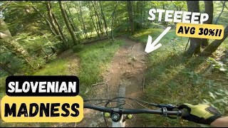
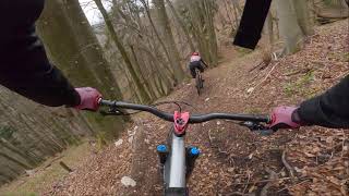
Alternative fun section of the lower half of Krim 2.0 descent with technical and steep sections. The name of the trail comes from the fact that a brown bear with his family was spotted twice in this part of the forest during the construction of the trail. However, since this is the third version of the descent from the Krim, the number 3 has crept in the name of M3DO. Thanks goes to the hard-working trailbuilding team from Dragomer.

Access Info

See Trailforks map.

This trail is unsanctioned.

Recent Activity on Trail

Past Week
  • 0 rides
  •  
6 Months
  • 16 rides
  • 26 miles avg distance
All
  • 26 rides
  • Last: Jun 23, 2026
c1c2c3c4
January
February
March
April
May
June
July
August
September
October
November
December
update trails status or condition

M3DO Trail Reports

statusdatedescription
May 2, 2025 @ 2:11pm
May 2, 2025
The trail is covered with leaves, making it hard to ride, especially on the steepest part. Otherwise, it's rideable, and all it would take to...
Jul 14, 2024 @ 3:53am
Jul 14, 2024
Damp, slippery on places.
Jan 4, 2024 @ 8:38am
Jan 4, 2024
Trail is full of leaves(roots and branches bellow) which makes it really difficult to ride
Apr 11, 2023 @ 6:15pm
Apr 11, 2023
Trail is in perfect condition - shaped an no leaves
Mar 24, 2023 @ 2:16am
Mar 24, 2023
Lots of leaves covering the trail in the upper part, a fallen tree in a faster section near the bottom (at the bottom of a steep-ish chute).
more »
Status:
on May 2, 2025
Variable
Avg: 4.13 (1 votes)
Your vote: 0

view (500)
close
3D
Trail Conditions
  • Unknown
  • Snow Groomed
  • Snow Packed
  • Snow Covered
  • Snow Cover Partial
  • Freeze/thaw Cycle
  • Icy
  • Prevalent Mud
  • Wet
  • Variable
  • Ideal
  • Dry
  • Very Dry
Trail Flow (Ridden Direction)
Trailforks scans users ridelogs to determine the most popular direction each trail is ridden. A good flowing trail network will have most trails flowing in a single direction according to their intension.
The colour categories are based on what percentage of riders are riding a trail in its intended direction.
  • > 96%
  • > 90%
  • > 80%
  • > 70%
  • > 50%
  • < 50%
  • bi-directional trail
  • no data
Trail Last Ridden
Trailforks scans ridelogs to determine the last time a trail was ridden.
  • < 2 days
  • < 1 week
  • < 2 weeks
  • < 1 month
  • < 6 months
  • > 6 months
Trail Ridden Direction
The intended direction a trail should be ridden.
  • Downhill Only
  • Downhill Primary
  • Both Directions
  • Uphill Primary
  • Uphill Only
  • One Direction
Contribute Details
Colors indicate trail is missing specified detail.
  • Description
  • Photos
  • Description & Photos
  • Videos
Trail Popularity ?
Trailforks scans ridelogs to determine which trails are ridden the most in the last 9 months. Trails are compared with nearby trails in the same city region with a possible 25 colour shades. Think of this as a heatmap, more rides = more kinetic energy = warmer colors.
  • most popular
  • popular
  • less popular
  • not popular
ATV/ORV/OHV Filter
Max Vehicle Width
inches
US Cell Coverage
Legend
cell carrier legend

Radar Time
Activity Recordings
Trailforks uses anonymized public activity data. ?
Activity Recordings
Trailforks uses anonymized public activity data. ?
Personal Heatmap
Activity Types
all / none
Options
2
Date range month
Winter Trails
Warning A routing network for winter maps does not exist. Selecting trails using the winter trails layer has been disabled.
Missing Trails
Most Popular
Least Popular
Trails are colored based on popularity. The more popular a trail is, the more red. Less popular trails trend towards green.
Jump Magnitude Heatmap
Heatmap of where riders jump on trails. Zoom in to see individual jumps, click circles to view jump details.
BC Backroad Status

Service Road Atlas is a free to use, community-driven service for viewing and creating reports on the numerous back-country service roads around B.C. and Alberta.

map legend
Slope Aspect
Direction the slope faces
Flat N NE E SE S SW W NW
Trails Deemphasized
Trails are shown in grey.
disable
Only show trails with no bike usage.
Enable
Suggested Layers
Based on selected activity type

    Save the current map location and zoom level as your default home location whenever this page is loaded.

    Save
        Directions to m3do trailhead (45.909230, 14.484750)

        Photos

        2 more »
        119 |
        Apr 27, 2021 @ 12:53pm
        Apr 27, 2021
        149 |
        Apr 27, 2021 @ 12:53pm
        Apr 27, 2021

        Videos

        2 more »
        youtuber STEEPEST TRAIL I HAVE EVER RIDDEN?! | Krim...
        9:55 | 363 | Sep 27, 2022 , Ig
        MTB Krim 2.5 & M3DO // April 2021
        8:55 | 544 | Jul 22, 2021 , Ig

        Reviews / Comments

        No reviews yet, be the first to write a review or ask a question.
        Use trail reports to comment on trail conditions.


        We hope you've been enjoying Trailforks!

        Create a FREE account to view trail comments and much more.

        • #320616 - 1,295 views

        Frequently Asked Questions About M3DO

        Where is M3DO located?
        M3DO is located in Krim, Ig, Slovenia. It is part of the Krim trail network. The trailhead is located at coordinates 45.90923, 14.48475.
        How hard is M3DO?
        M3DO is rated as Black difficulty. The average grade is 29.5%.
        What is the elevation gain for M3DO?
        M3DO has 15 ft of elevation gain. The trail has 1,136 ft of elevation descent. The elevation ranges from 1,252 ft to 2,388 ft.
        Is M3DO a point to point trail?
        Yes, M3DO is a point to point trail. The direction is Downhill Only. The trail type is singletrack.

        Hit the Trail

        Open in App

        Get this trail on your phone instantly.
        open trail in app

        Download Trail

        Save to wishlist, Garmin & download.
        save the trail

        Find Related Routes

        Find routes and users activities that include this trail.
        find routes for this trail

        You must enter a description before submitting.