This trail is permanently closed/decommissioned
4,764 ft
Distance
-589 ft
Descent
00:07:47
Avg time

Make or Brake Details

  • Activities
    • Mountain Bike
    • E-Bike
  • Riding Area
    Traquair Trails
    Innerleithen
  • Difficulty Rating
  • Voted Difficulty
    Black (2 votes)
  • Trail Type
    Singletrack
  • Bike Type
    DH, AM
  • Direction
    One Direction
    Popular direction shown
  • Physical Rating
    Easy
  • Dogs Allowed
    Yes
  • eBike Allowed
    Yes up to Class 1
  • Ride in Rain
    Yes
  • Global Ranking
    #5865 in Mountain Biking [+]
    • #3268 in E-Biking
  • Local Popularity
    10 in Mountain Biking [+]
    • 5 in E-Biking

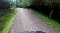
Great fast, flowy, bermy trail, with optional air if you want it. This is the easiest of the 4 main trails and generally the one to start with - watch your speed if you don't want air. It offers a good mix of forest and open views of the valley if you can tear your eyes from the trail. Nothing too technical. Worth hoofing up the path from the forestry road to the start section once, otherwise easier to start from where the forest road intersects with the top of the middle section. Carries on into Cadon Bank for a fun ride to the valley floor.

Bike Park

Local Trail Association
More Stats for Make or Brake mountain bike trail trail
  • Altitude change
    -589 ft
  • Altitude min
    943 ft
  • Altitude max
    1,531 ft
  • Altitude start
    1,531 ft
  • Altitude end
    942 ft
  • Grade
    -12.4%
  • Grade max
    -38%
  • Distance down
    4,659 ft
  • Distance flat
    105 ft
  • Avg time
    00:07:47
  • Avg reverse time
    00:28:55
  • view trail stats
Status:
on Oct 30, 2020
Variable
Avg: 4.25 (12 votes)
Your vote: 0

view (832)
close
3D
Trail Conditions
  • Unknown
  • Snow Groomed
  • Snow Packed
  • Snow Covered
  • Snow Cover Inadequate
  • Freeze/thaw Cycle
  • Icy
  • Prevalent Mud
  • Wet
  • Variable
  • Ideal
  • Dry
  • Very Dry
Trail Flow (Ridden Direction)
Trailforks scans users ridelogs to determine the most popular direction each trail is ridden. A good flowing trail network will have most trails flowing in a single direction according to their intension.
The colour categories are based on what percentage of riders are riding a trail in its intended direction.
  • > 96%
  • > 90%
  • > 80%
  • > 70%
  • > 50%
  • < 50%
  • bi-directional trail
  • no data
Trail Last Ridden
Trailforks scans ridelogs to determine the last time a trail was ridden.
  • < 2 days
  • < 1 week
  • < 2 weeks
  • < 1 month
  • < 6 months
  • > 6 months
Trail Ridden Direction
The intended direction a trail should be ridden.
  • Downhill Only
  • Downhill Primary
  • Both Directions
  • Uphill Primary
  • Uphill Only
  • One Direction
Contribute Details
Colors indicate trail is missing specified detail.
  • Description
  • Photos
  • Description & Photos
  • Videos
Trail Popularity ?
Trailforks scans ridelogs to determine which trails are ridden the most in the last 9 months. Trails are compared with nearby trails in the same city region with a possible 25 colour shades. Think of this as a heatmap, more rides = more kinetic energy = warmer colors.
  • most popular
  • popular
  • less popular
  • not popular
ATV/ORV/OHV Filter
Max Vehicle Width
inches

Radar Time
x Activity Recordings
Trailforks users anonymized public ridelogs from the past 6 months.
  • mountain biking recent
  • mountain biking (>6 month)
  • hiking (1 year)
  • moto (1 year)
Activity Recordings
Trailforks users anonymized public skilogs from the past 12 months.
  • Downhill Ski
  • Backcountry Ski
  • Nordic Ski
  • Snowmobile
Winter Trails
Warning A routing network for winter maps does not exist. Selecting trails using the winter trails layer has been disabled.
x Missing Trails
Most Popular
Least Popular
Trails are colored based on popularity. The more popular a trail is, the more red. Less popular trails trend towards green.
Jump Magnitude Heatmap
Heatmap of where riders jump on trails. Zoom in to see individual jumps, click circles to view jump details.
Trails Deemphasized
Trails are shown in grey.
disable
Only show trails with NO bikes.
enable

Save the current map location and zoom level as your default home location whenever this page is loaded.

Save
      Directions to make-or-brake trailhead (55.606880, -3.036750)
      update trails status or condition

      Make or Brake Trail Reports

      Recent Ridelog Activity on Trail

      Past Week
      • 0 rides
      •  
      6 Months
      • 0 rides
      •  
      All
      • 680 rides
      • Last: Nov 29, 2022

      Photos

      more »
      73 |
      Jun 9, 2019 @ 2:50am
      Jun 9, 2019
      79 |
      Jun 9, 2019 @ 2:50am
      Jun 9, 2019
      66 |
      Jun 9, 2019 @ 2:50am
      Jun 9, 2019
      361 |
      Jan 19, 2018 @ 8:14am
      Jan 19, 2018

      Reviews / Comments

      No reviews yet, be the first to write a review or ask a question.
      Use trail reports to comment on trail conditions.


      We hope you've been enjoying Trailforks!

      Create a FREE account to view trail comments and much more.

      Videos

      more »
      Make or Brake - Innerleithen
      4:36 | 497 | Jun 9, 2021 , Innerleithen
      innerleithen
      123 | Jun 23, 2021 , Innerleithen
      Innerleithen 14/06/21
      91 | Jun 17, 2021 , Innerleithen
      Make Or Brake | Innerleithen
      0:42 | 391 | Aug 1, 2020 , Innerleithen
      • By brenthillier NSMBA TRAILFORKS & contributors
      • #21870 - 4,578 views