more stats
1.1 miles
Distance
-738 ft
Descent
2,967 ft
High Point
-738 ft
Altitude change
2,229 ft
Altitude min
2,967 ft
Altitude start
2,231 ft
Altitude end
-13.2%
Grade
-39.9%
Grade max
10 ft
Distance climb
1 mile
Distance down
194 ft
Distance flat

MaPiNi Details

  • Activities
    • Mountain Bike
    • E-Bike
    • Hike
    • Trail Running
  • Riding Area
    San Giovanni Rotondo
    san giovanni rotondo
  • AKA
    Due Conventi - versante SGR
  • Difficulty Rating
  • Local Popularity
    85 in Mountain Biking [+]
    • 5 in E-Biking
    • 5 in Trail Running
    • 5 in Hiking
  • Global Ranking
    #186838 in Mountain Biking [+]
    • #154569 in E-Biking
    • #248488 in Trail Running
    • #256472 in Hiking
  • Hiking SAC Scale
    T1 Hiking
  • Trail Type
    Singletrack
  • Bike Type
    AM, XC
  • Direction
    Downhill Primary
  • Dogs Allowed
    Yes
  • eBike Allowed
    Yes up to Class 1
  • TTFs on Trail
    Rock Garden, Other

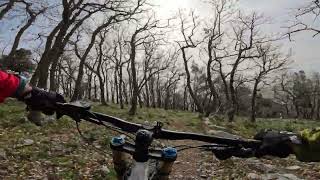
Discesa che ricalca il sentiero "due conventi", va dal cancello accanto le piscine garganiche fino al cancelletto sotto la nuova area picnic in prossimità del parcheggio multipiano
Singletrack tecnico e interessante, con parecchi switchback e droppettini dati dai gradini di roccia

Recent Activity on Trail

Past Week
  • 0 rides
  •  
6 Months
  • 0 rides
  •  
All
  • 1 rides
  • Last: Jan 27, 2024
update trails status or condition

MaPiNi Trail Reports

statusdatedescription
Jan 5, 2025 @ 10:41am
Jan 5, 2025
2-3 alberi caduti costringono a deviare un po' la traccia, comunque percorribile
Sep 13, 2024 @ 12:39am
Sep 13, 2024
Alberi caduti a terra lungo il sentiero. Danni dovuti all'incendio divampato intorno a ferragosto.
more »
Status:
on Jan 5, 2025
Variable
no votes yet
Your vote: 0

view (2)
close
3D
Trail Conditions
  • Unknown
  • Snow Groomed
  • Snow Packed
  • Snow Covered
  • Snow Cover Partial
  • Freeze/thaw Cycle
  • Icy
  • Prevalent Mud
  • Wet
  • Variable
  • Ideal
  • Dry
  • Very Dry
Trail Flow (Ridden Direction)
Trailforks scans users ridelogs to determine the most popular direction each trail is ridden. A good flowing trail network will have most trails flowing in a single direction according to their intension.
The colour categories are based on what percentage of riders are riding a trail in its intended direction.
  • > 96%
  • > 90%
  • > 80%
  • > 70%
  • > 50%
  • < 50%
  • bi-directional trail
  • no data
Trail Last Ridden
Trailforks scans ridelogs to determine the last time a trail was ridden.
  • < 2 days
  • < 1 week
  • < 2 weeks
  • < 1 month
  • < 6 months
  • > 6 months
Trail Ridden Direction
The intended direction a trail should be ridden.
  • Downhill Only
  • Downhill Primary
  • Both Directions
  • Uphill Primary
  • Uphill Only
  • One Direction
Contribute Details
Colors indicate trail is missing specified detail.
  • Description
  • Photos
  • Description & Photos
  • Videos
Trail Popularity ?
Trailforks scans ridelogs to determine which trails are ridden the most in the last 9 months. Trails are compared with nearby trails in the same city region with a possible 25 colour shades. Think of this as a heatmap, more rides = more kinetic energy = warmer colors.
  • most popular
  • popular
  • less popular
  • not popular
ATV/ORV/OHV Filter
Max Vehicle Width
inches
US Cell Coverage
Legend
cell carrier legend

Radar Time
Activity Recordings
Trailforks uses anonymized public activity data. ?
Activity Recordings
Trailforks uses anonymized public activity data. ?
Personal Heatmap
Activity Types
all / none
Options
2
Date range month
Winter Trails
Warning A routing network for winter maps does not exist. Selecting trails using the winter trails layer has been disabled.
Missing Trails
Most Popular
Least Popular
Trails are colored based on popularity. The more popular a trail is, the more red. Less popular trails trend towards green.
Jump Magnitude Heatmap
Heatmap of where riders jump on trails. Zoom in to see individual jumps, click circles to view jump details.
BC Backroad Status

Service Road Atlas is a free to use, community-driven service for viewing and creating reports on the numerous back-country service roads around B.C. and Alberta.

map legend
Slope Aspect
Direction the slope faces
Flat N NE E SE S SW W NW
Trails Deemphasized
Trails are shown in grey.
disable
Only show trails with no bike usage.
Enable
Suggested Layers
Based on selected activity type

    Save the current map location and zoom level as your default home location whenever this page is loaded.

    Save
        Directions to mapini trailhead (41.714680, 15.688770)

        Photos

        No photos have been added for MaPiNi yet, add a photo.

        Videos

        1 more »
        Mapini - Gargano MTB - San Giovanni Rotondo
        6:07 | 86 | Sep 12, 2024 , san giovanni rotondo

        Reviews / Comments

        No reviews yet, be the first to write a review or ask a question.
        Use trail reports to comment on trail conditions.


        We hope you've been enjoying Trailforks!

        Create a FREE account to view trail comments and much more.

        • By jinbeTF Pro & contributors
        • #793052 - 142 views

        Frequently Asked Questions About MaPiNi

        Where is MaPiNi located?
        MaPiNi is located in San Giovanni Rotondo, san giovanni rotondo, Italy. It is part of the San Giovanni Rotondo trail network. The trailhead is located at coordinates 41.71468, 15.68877.
        How hard is MaPiNi?
        MaPiNi is rated as Blue difficulty. The average grade is 13.2%.
        What is the elevation gain for MaPiNi?
        The trail has 738 ft of elevation descent. The elevation ranges from 2,229 ft to 2,967 ft.
        Is MaPiNi a point to point trail?
        MaPiNi is not a point to point trail. The direction is Downhill Primary. The trail type is singletrack.

        Hit the Trail

        Open in App

        Get this trail on your phone instantly.
        open trail in app

        Download Trail

        Save to wishlist, Garmin & download.
        save the trail

        Find Related Routes

        Find routes and users activities that include this trail.
        find routes for this trail

        You must enter a description before submitting.