1.4 miles
Distance
30 ft
Climb
-2,094 ft
Descent
00:24:58
Avg time

Martini Details

  • Activities
    • Mountain Bike
    • E-Bike
    • Hike
    • Trail Running
  • Riding Area
  • Difficulty Rating
  • Voted Difficulty
    Black Diamond (1 vote)
  • Trail Type
    Singletrack
  • Bike Type
    DH, AM
  • Direction
    Downhill Primary
    Popular direction shown
  • Climb Difficulty
    Blue
  • Physical Rating
    Moderate
  • Alpine Trail
    Yes
  • Dogs Allowed
    Yes
  • eBike Allowed
    Yes up to Class 1
  • TTFs on Trail
    Rock Garden
  • Global Ranking
    #56938 in Mountain Biking [+]
    • #22106 in E-Biking
    • #88171 in Hiking
  • Local Popularity
    20 in Mountain Biking [+]
    • 20 in E-Biking
    • 20 in Trail Running
    • 20 in Hiking

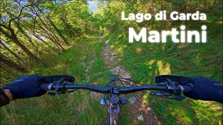
Rocky Trail descending monte Velo. It's quite steep but not extreme, no drops or jumps. It's a natural trail so no maintenance.

Access Info

Climb on an asphalt road for about 10km untill "chiesa san francesco" sign.

More Stats for Martini mountain bike trail trail
  • Altitude change
    -2,064 ft
  • Altitude min
    1,035 ft
  • Altitude max
    3,099 ft
  • Altitude start
    3,099 ft
  • Altitude end
    1,035 ft
  • Grade
    -28.347%
  • Grade max
    -70.837%
  • Grade min
    25.186%
  • Distance climb
    297 ft
  • Distance down
    1 mile
  • Distance flat
    89 ft
  • Avg time
    00:24:58
  • view trail stats
Status:
on Sep 18, 2021
Variable
Avg: 3.5 (8 votes)
Your vote: 0

view (55)
close
3D
Trail Conditions
  • Unknown
  • Snow Groomed
  • Snow Packed
  • Snow Covered
  • Snow Cover Inadequate
  • Freeze/thaw Cycle
  • Icy
  • Prevalent Mud
  • Wet
  • Variable
  • Ideal
  • Dry
  • Very Dry
Trail Flow (Ridden Direction)
Trailforks scans users ridelogs to determine the most popular direction each trail is ridden. A good flowing trail network will have most trails flowing in a single direction according to their intension.
The colour categories are based on what percentage of riders are riding a trail in its intended direction.
  • > 96%
  • > 90%
  • > 80%
  • > 70%
  • > 50%
  • < 50%
  • bi-directional trail
  • no data
Trail Last Ridden
Trailforks scans ridelogs to determine the last time a trail was ridden.
  • < 2 days
  • < 1 week
  • < 2 weeks
  • < 1 month
  • < 6 months
  • > 6 months
Trail Ridden Direction
The intended direction a trail should be ridden.
  • Downhill Only
  • Downhill Primary
  • Both Directions
  • Uphill Primary
  • Uphill Only
  • One Direction
Contribute Details
Colors indicate trail is missing specified detail.
  • Description
  • Photos
  • Description & Photos
  • Videos
Trail Popularity ?
Trailforks scans ridelogs to determine which trails are ridden the most in the last 9 months. Trails are compared with nearby trails in the same city region with a possible 25 colour shades. Think of this as a heatmap, more rides = more kinetic energy = warmer colors.
  • most popular
  • popular
  • less popular
  • not popular
ATV/ORV/OHV Filter
Max Vehicle Width
inches

Radar Time
x Activity Recordings
Trailforks users anonymized public ridelogs from the past 6 months.
  • mountain biking recent
  • mountain biking (>6 month)
  • hiking (1 year)
  • moto (1 year)
Activity Recordings
Trailforks users anonymized public skilogs from the past 12 months.
  • Downhill Ski
  • Backcountry Ski
  • Nordic Ski
  • Snowmobile
Jump Magnitude Heatmap
Heatmap of where riders jump on trails. Zoom in to see individual jumps, click circles to view jump details.
Trails Deemphasized
Trails are shown in grey.
disable
Only show trails with NO bikes.
enable

Save the current map location and zoom level as your default home location whenever this page is loaded.

Save
      Directions to martini trailhead (45.895648, 10.916420)
      update trails status or condition

      Martini Trail Reports

      statusdatedescription
      Sep 18, 2021 @ 7:55am
      Sep 18, 2021
      reporter
      Oct 8, 2020 @ 2:20pm
      Oct 8, 2020
      Prime conditions - natural trail so quite rough ;)
      Jul 8, 2020 @ 12:52pm
      Jul 8, 2020
      Jun 13, 2020 @ 8:06am
      Jun 13, 2020
      reporter The trail is clear from trees, but be carefull due to the stumps on the ground. Overall the trail is totally rideable
      Oct 13, 2019 @ 4:52am
      Oct 13, 2019
      A lots of tree on the trail. For most of them you can ride around.
      view all reports »

      Recent Ridelog Activity on Trail

      Past Week
      • 0 rides
      •  
      6 Months
      • 3 rides
      • 18 miles avg distance
      All
      • 47 rides
      • Last: Dec 20, 2022

      Photos

      more »
      74 |
      Aug 4, 2021 @ 10:48pm
      Aug 4, 2021

      2 Reviews & Comments

      • + 0
      Igel-ONE (May 30, 2017 at 21:49)
      Nice trail, but the trail is longer than the track show's it.
      [Reply]
      • + 2
      caval AGBA (Jul 23, 2017 at 5:51)
      That's true but from there you have different options and the name of the trail is not martini anymore. |_|
      [Reply]


      Login or Sign Up to Comment

      Videos

      more »
      youtuber Martini Trail - Gardasee - MTB-Trails
      12:39 | 809 | May 29, 2020 , My City
      • subscribe
      • flag
      • login to download gpx or kml files.