
more stats
4.9 miles
Distance
201 ft
Climb
-200 ft
Descent
00:33:33
Avg time
1 ft
Altitude change
851 ft
Altitude min
1,000 ft
Altitude max
916 ft
Altitude start
919 ft
Altitude end
-10%
Grade max
9%
Grade min
4,856 ft
Distance climb
5,112 ft
Distance down
3 miles
Distance flat
00:33:33
Avg time

Maxwell Trail Details

  • Activities
    • Mountain Bike
    • E-Bike
    • Hike
    • Trail Running
  • Riding Area
    Mary Gay Maxwell Tract
    Austin, Texas
  • Difficulty Rating
  • Voted Difficulty
    Blue (3 votes)
  • Local Popularity
    95 in Mountain Biking [+]
    • 95 in E-Biking
    • 100 in Trail Running
    • 95 in Hiking
  • Global Ranking
    #9894 in Mountain Biking [+]
    • #13845 in Trail Running
    • #17579 in Hiking
  • Trail Type
    Singletrack
  • Bike Type
    AM, XC
  • Direction
    One Direction
  • Climb Difficulty
    Green
  • Physical Rating
    Moderate
  • Trail Visibility
    Always easy to follow
  • Season
    Year round
  • eBike Allowed
  • TTFs on Trail
    Drop, Rock Garden

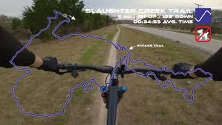
The Slaughter Creek Trail has a little bit of everything - flow sections, gnarly rock gardens, a couple of nice drops and plenty of sharp off-camber limestone that central Texas is known for. Bikes are only allowed to ride clockwise, while hikers and those riding horses must use the trail in a counter clockwise direction. The first 100 yard section is flat. It's a good warm up to a small hill filled with jagged limestone outcroppings. At first the extended rock garden doesn't seem so bad, but as you wind up and around it gets more difficult to find a good line. After you reach the top, there is a dusty and loose section before heading back down. There is a fantastic ledge on the initial decent and then the trail splits. Head right for a shortened loop. Head left to ride the longer loop. If you decide to man up and go left, the trail weaves its way in and out of cedar trees, smaller rock gardens and some actual dirt. Once you make it out of this section, you will begin riding up the other side of the hill you conquered at the beginning of the ride. This part is exposed with a lot of fist-sized loose rocks and and pebbles over hard pack. You will then dive back down and back up the hill to another rocky, loose section that's pretty fast. After rolling through a dry creek and more cedar trees, you're in the home stretch. The final section is also fast and flowing all the way back to the parking lot. It's impossible to get lost on this trail as there is just one main loop.

Access Info

Turn into the main driveway off FM 1826. Drive to the parking lot and you'll see an opening through a gate that leads to the trail hea.

Disclaimer

There is a gate that automatically closes at sunset. Dogs are not allowed. Check Slaughter Creek's Facebook page before heading out there. The trail is closed after even light rain.

Local Trail Association

Recent Activity on Trail

Past Week
  • 5 rides
  • 18 miles average
6 Months
  • 76 rides
  • 13 miles avg distance
All
  • 953 rides
  • Last: Sep 21, 2026
c1c2c3c4
January
February
March
April
May
June
July
August
September
October
November
December
update trails status or condition

Maxwell Trail Trail Reports

statusdatedescription
Jul 30, 2026 @ 7:05am (America/Matamoros)
Jul 30, 2026
May 9, 2026 @ 9:53am (America/Chicago)
May 9, 2026
Jun 29, 2025 @ 12:59pm
Jun 29, 2025
Mar 2, 2025 @ 8:56am
Mar 2, 2025
Sep 4, 2024 @ 9:45am
Sep 4, 2024
A little too wet in lower spots creating mud caked tires. Advise waiting another day or two to ride.
more »
Status:
on Jul 30, 2026
Ideal
Avg: 4.03 (29 votes)
Your vote: 0

view (8,181)
close
      Directions to maxwell-trail trailhead (30.206300, -97.906740)

      Photos

      22 more »
      mtb
      753 |
      Apr 1, 2020 @ 6:28am
      Apr 1, 2020
      mtb
      76 |
      Jun 30, 2025 @ 12:40pm
      Jun 30, 2025
      mtb
      146 |
      Jan 10, 2024 @ 1:57pm
      Jan 10, 2024
      mtb
      221 |
      Nov 21, 2021 @ 4:25am
      Nov 21, 2021

      Videos

      4 more »
      Hot Laps at Slaughter Creek
      mtb
      7:50 | 545 | Jul 5, 2022 , Austin
      SATN Mountain Biking (5) - Slaughter Creek Trail
      mtb
      12:34 | 706 | Dec 12, 2020 , Austin
      South Austin Trail Network - Slaughter Creek Trail
      mtb
      3:50 | 755 | Mar 28, 2021 , Austin
      Main Loop - Slaughter Creek Trail - Mountain...
      mtb
      11:08 | 2851 | Feb 7, 2020 , Austin

      Routes with this trail

      24 miles 769 ft 30
      to Slaughter Creek and back
      17 miles 602 ft 13
      This is the west route for the 2023 SATN Social on October 21st.
      17 miles 595 ft 15 Loop
      2022 SATN SOCIAL WEST LooP
      4.1
      29 Ratings
      5 45%
      4 31%
      3 14%
      2 3%
      1 7%

      7 Reviews & Comments

      Isathehomie Isathehomie
      This trail is a great test of basic skills. Recently discovered it a few weeks ago and it’s the perfect length for a quick hour ride. It will test your uphill climbing skills as the majority of the first section is a solid chunk of uphill grade. Finding that little bench at the top is so nice to stop and catch a breath. Remember to be courteous to the hikers on the second half, as you are more likely to run into them. I’ve been on a hiatus for about 5 years and I have found this trail to offer a good challenge to brush up my endurance and rusty skills.
      JesusLIpO
      Optimal conditions one of the funnest trails in west Austin
      pizzadrop34
      As of Oct 2020, this is the updated URL for the Facebook page for trail OPEN/CLOSED status: www.facebook.com/slaughtercrktrl/

      We hope you've been enjoying Trailforks!

      Create a FREE account to view all trail reviews and much more.

      Frequently Asked Questions

      Where is Maxwell Trail located?
      Maxwell Trail is located in Mary Gay Maxwell Tract, Austin, Texas, United States. It is part of the Mary Gay Maxwell Tract trail network. The trailhead is located at coordinates 30.2063, -97.90674.
      How hard is Maxwell Trail?
      Maxwell Trail is rated as Blue difficulty. The physical rating is Moderate. The climb difficulty is rated Green.
      What is the elevation gain for Maxwell Trail?
      Maxwell Trail has 201 ft of elevation gain. The trail has 200 ft of elevation descent. The elevation ranges from 851 ft to 1,000 ft.
      Is Maxwell Trail a point to point trail?
      Yes, Maxwell Trail is a point to point trail. The direction is One Direction. The trail type is singletrack.
      How long is Maxwell Trail?
      Maxwell Trail is 4.9 miles long. The trail type is singletrack.
      Are dogs allowed on Maxwell Trail?
      There is no information about dogs being allowed on Maxwell Trail. Check with local trail managers or the trail page for the latest access rules.
      When is the best time of year to ride Maxwell Trail?
      Based on activity log data, the most popular months to ride Maxwell Trail are:
      • September (38 activities)
      • August (37 activities)
      • October (32 activities)
      Check the reports page for current trail conditions.
      How do I access Maxwell Trail? Where is the closest parking trailhead?
      The closest parking and trailhead locations to Maxwell Trail are: View all parking locations in the area.
      How long does it take to ride Maxwell Trail?
      Based on recorded activities, it takes an average of 32 minutes to ride Maxwell Trail. The trail is 4.9 miles long. Actual times will vary based on fitness level, conditions, and pace. View recent activity logs for more details.
      How busy is Maxwell Trail?
      Maxwell Trail is a very popular trail. There have been 5,660 recorded activities on this trail. The trail has received 8,181 check-ins. View recent activity on this trail.

      Hit the Trail

      Open in App

      Get this trail on your phone instantly.

      open trail in app

      Download Trail

      Save to wishlist, Garmin & download.
      save the trail

      Find Related Routes

      Find routes and users activities that include this trail.
      find routes for this trail

      You must enter a description before submitting.