more stats
1.8 miles
Distance
139 ft
Climb
-1,731 ft
Descent
00:23:26
Avg time
-1,592 ft
Altitude change
3,375 ft
Altitude min
5,036 ft
Altitude max
4,967 ft
Altitude start
3,376 ft
Altitude end
-16.6%
Grade
-118.2%
Grade max
25.2%
Grade min
1,490 ft
Distance climb
1 mile
Distance down
331 ft
Distance flat
00:23:26
Avg time

Merlet Details

  • Activities
    • Hike
    • Mountain Bike
    • E-Bike
    • Trail Running
  • Riding Area
  • Difficulty Rating
  • Local Popularity
    50 in Mountain Biking [+]
    • 80 in E-Biking
    • 60 in Trail Running
    • 60 in Hiking
  • Global Ranking
    #91526 in Mountain Biking [+]
    • #24773 in E-Biking
    • #91046 in Trail Running
    • #81775 in Hiking
  • Hiking SAC Scale
    T1 Hiking
  • Trail Type
    Singletrack
  • Bike Type
    DH, AM
  • Direction
    Downhill Only
    Popular Direction Shown
  • Alpine Trail
    Yes
  • Dogs Allowed
    Yes
  • eBike Allowed
    Yes up to Class 1

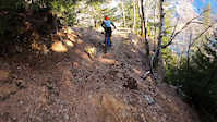
Jolie singletrack avec des racines et des pierres, le début est exposé, avec la traversé d'un pont métallique. A eviter sur le mouillé
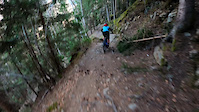
This trail can lead you on to Le Petit Balcon Sud, which is a trail leading from Les Houches all the way to Les Praz with many ways to get down into the villages along the way. It is also important to mention the beginning of this trail is very rocky, exposed and dangerous. Very early on there is metal bridge crossing a stream with a plaque in commemoration of someone who fell trying to cross before the bridge was put in place. This bridge was put up in Summer of 2017. Once you get beyond this bridge the trail become much less exposed but remains rocky. Watch out for leaves and hikers.

Recent Activity on Trail

Past Week
  • 0 rides
  •  
6 Months
  • 2 rides
  • 9 miles avg distance
All
  • 28 rides
  • Last: Jun 22, 2026
c1c2c3c4
January
February
March
April
May
June
July
August
September
October
November
December
update trails status or condition

Merlet Trail Reports

statusdatedescription
Nov 4, 2024 @ 5:41am
Nov 4, 2024
Un passage compliqué dans le début, au niveau du passage du Torrent de Lapaz (de gros blocs sont tombés) mais ça passe. Tout le reste en...
May 8, 2024 @ 7:37am
May 8, 2024
Trail is closed.
May 9, 2023 @ 3:02pm
May 9, 2023
A large rock has fallen on to the trail just after the metal bridge (see photo) and is partially blocking the trail but it is not to hard to wheel...
Mar 25, 2022 @ 5:24am
Mar 25, 2022
Bien sec, se roule bien !
May 9, 2021 @ 1:04pm
May 9, 2021
Bien sec , parfait !
more »
Status:
on Nov 4, 2024
Ideal
Avg: 4.32 (3 votes)
Your vote: 0

view (245)
close
3D
Trail Conditions
  • Unknown
  • Snow Groomed
  • Snow Packed
  • Snow Covered
  • Snow Cover Partial
  • Freeze/thaw Cycle
  • Icy
  • Prevalent Mud
  • Wet
  • Variable
  • Ideal
  • Dry
  • Very Dry
Trail Flow (Ridden Direction)
Trailforks scans users ridelogs to determine the most popular direction each trail is ridden. A good flowing trail network will have most trails flowing in a single direction according to their intension.
The colour categories are based on what percentage of riders are riding a trail in its intended direction.
  • > 96%
  • > 90%
  • > 80%
  • > 70%
  • > 50%
  • < 50%
  • bi-directional trail
  • no data
Trail Last Ridden
Trailforks scans ridelogs to determine the last time a trail was ridden.
  • < 2 days
  • < 1 week
  • < 2 weeks
  • < 1 month
  • < 6 months
  • > 6 months
Trail Ridden Direction
The intended direction a trail should be ridden.
  • Downhill Only
  • Downhill Primary
  • Both Directions
  • Uphill Primary
  • Uphill Only
  • One Direction
Contribute Details
Colors indicate trail is missing specified detail.
  • Description
  • Photos
  • Description & Photos
  • Videos
Trail Popularity ?
Trailforks scans ridelogs to determine which trails are ridden the most in the last 9 months. Trails are compared with nearby trails in the same city region with a possible 25 colour shades. Think of this as a heatmap, more rides = more kinetic energy = warmer colors.
  • most popular
  • popular
  • less popular
  • not popular
ATV/ORV/OHV Filter
Max Vehicle Width
inches
US Cell Coverage
Legend
cell carrier legend

Radar Time
Activity Recordings
Trailforks uses anonymized public activity data. ?
Activity Recordings
Trailforks uses anonymized public activity data. ?
Personal Heatmap
Activity Types
all / none
Options
2
Date range month
Winter Trails
Warning A routing network for winter maps does not exist. Selecting trails using the winter trails layer has been disabled.
Missing Trails
Most Popular
Least Popular
Trails are colored based on popularity. The more popular a trail is, the more red. Less popular trails trend towards green.
Jump Magnitude Heatmap
Heatmap of where riders jump on trails. Zoom in to see individual jumps, click circles to view jump details.
BC Backroad Status

Service Road Atlas is a free to use, community-driven service for viewing and creating reports on the numerous back-country service roads around B.C. and Alberta.

map legend
Slope Aspect
Direction the slope faces
Flat N NE E SE S SW W NW
Trails Deemphasized
Trails are shown in grey.
disable
Only show trails with no bike usage.
Enable
Suggested Layers
Based on selected activity type

    Save the current map location and zoom level as your default home location whenever this page is loaded.

    Save
        Directions to merlet trailhead (45.908510, 6.821910)

        Photos

        15 more »
        71 |
        Jun 4, 2023 @ 10:43am
        Jun 4, 2023
        54 |
        May 29, 2023 @ 11:42pm
        May 29, 2023
        41 |
        May 29, 2023 @ 11:40pm
        May 29, 2023
        66 |
        May 9, 2023 @ 8:42am
        May 9, 2023

        Videos

        3 more »
        CHAM(bike)LINES Merlet
        2:02 | 565 | Nov 5, 2018 , Chamonix
        0:12 | 154 | Mar 27, 2022 , Chamonix
        0:12 | 102 | Mar 27, 2022 , Chamonix

        2 Reviews & Comments


        We hope you've been enjoying Trailforks!

        Create a FREE account to view trail comments and much more.

        • By tigre38TF Pro & contributors
        • #92263 - 2,797 views

        Frequently Asked Questions About Merlet

        Where is Merlet located?
        Merlet is located in Chamonix, France. It is part of the Chamonix trail network. The trailhead is located at coordinates 45.90851, 6.82191.
        How hard is Merlet?
        Merlet is rated as Red difficulty. The average grade is 16.6%.
        What is the elevation gain for Merlet?
        Merlet has 139 ft of elevation gain. The trail has 1,731 ft of elevation descent. The elevation ranges from 3,375 ft to 5,036 ft.
        Is Merlet a point to point trail?
        Yes, Merlet is a point to point trail. The direction is Downhill Only. The trail type is singletrack.

        Hit the Trail

        Open in App

        Get this trail on your phone instantly.
        open trail in app

        Download Trail

        Save to wishlist, Garmin & download.
        save the trail

        Find Related Routes

        Find routes and users activities that include this trail.
        find routes for this trail

        You must enter a description before submitting.