
more stats
5.2 miles
Distance
254 ft
Climb
-1,229 ft
Descent
00:38:10
Avg time
-977 ft
Altitude change
6,803 ft
Altitude min
7,796 ft
Altitude max
7,781 ft
Altitude start
6,804 ft
Altitude end
-3.6%
Grade
-42.2%
Grade max
18.8%
Grade min
5,272 ft
Distance climb
3 miles
Distance down
5,184 ft
Distance flat
00:38:10
Avg time

Middle Spinal Tap Details

  • Activities
    • Mountain Bike
  • Riding Area
    Pahvant Trail System
    Richfield, Utah
  • Difficulty Rating
  • Voted Difficulty
    Blue (4 votes)
  • Local Popularity
    100 in Mountain Biking
  • Global Ranking
    #94 in Mountain Biking
  • State Ranking
    #10 in Mountain Biking · Utah
  • Trail Type
    Singletrack
  • Bike Type
    DH, AM
  • Direction
    Downhill Only
    Popular Direction Shown
  • Season
    April - November
  • TTFs on Trail
    Berm, Jump
  • Year Opened
    2022
  • Land Owner
    US Forest Service

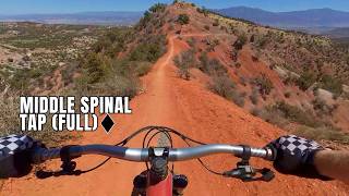
Middle Spinal Tap is a 5-mile extension of the Lower Spinal Tap trail. The trail starts with gentle slow rolling slopes with awesome views for about a mile. The trail then gets rowdy with steep descents, large banked turns, and plenty of jumps followed by a 1/4 mile easy climb before descending again through numerous jump lines and berms. The trail then finishes off with a brief climb before a final descent into Lower Spinal Tap.

The trail is rated as a black diamond due to areas of exposure and the fact that it leads into Lower Spinal Tap. However the trail is generally more intermediate in difficulty. If there is any chance of rain in the forecast, do not ride this trail. You will have a very long and miserable hike with no easy access to the roadway.

Access Info

Trail is accessed via the CCC road and FR 111.

Tags
BermsExposureJumpsViews

Trail Supporters

Local Trail Association

Recent Activity on Trail

Past Week
  • 9 rides
  • 21 miles average
6 Months
  • 288 rides
  • 21 miles avg distance
All
  • 869 rides
  • Last: Oct 30, 2026
c1c2c3c4
January
February
March
April
May
June
July
August
September
October
November
December
update trails status or condition

Middle Spinal Tap Trail Reports

Status:
on Oct 2, 2026
Ideal
Avg: 4.25 (48 votes)
Your vote: 0

view (3,553)
close
      Directions to middle-spinal-tap trailhead (38.765350, -112.211630)

      Photos

      17 more »
      mtb
      769 |
      Sep 20, 2024 @ 5:16pm
      Sep 20, 2024
      mtb
      682 |
      Sep 20, 2024 @ 5:15pm
      Sep 20, 2024
      mtb
      41 |
      Oct 6, 2026 @ 7:59am
      Oct 6, 2026
      mtb
      48 |
      Oct 6, 2026 @ 7:59am
      Oct 6, 2026

      Videos

      9 more »
      Middle Spinal Tap Full trail
      mtb
      24:58 | 116 | Jul 4, 2026 , Richfield
      A 30-kilometer downhill ride in Utah – the...
      mtb
      27:03 | 317 | Mar 28, 2026 , Richfield
      Spinal Tab Mid & Lower
      mtb
      20:41 | 305 | Jul 2, 2025 , Richfield
      Everyone LOVES this Trail. I HATED it - Kinda.
      mtb
      20:32 | 533 | Apr 14, 2025 , Richfield

      Routes with this trail

      ★ 4.7 • 19 miles • 504 ft • 3 • Shuttled •
      The full route, top to bottom. Typically you shuttle to the top, then make the drop. Dirt roads to the top...
      4.3 ★★★★★
      48 Ratings
      5 ★ 58%
      4 ★ 23%
      3 ★ 10%
      2 ★ 4%
      1 ★ 4%

      13 Reviews & Comments

      white-shark-424
      I may have liked this section (Middle) more than Lower Spinal tap. It’s just so fast! So flowy! So unique! Carry your speed and most of the jumps are possible on-sight. The berms are dreamy. Really epic trail!
      shannonhood shannonhood
      I agree with other comments. Upper spinal Green. Middle spinal Blue. Lower spinal Black by the time I go to the bottom ide forgotten the dull sections up top… but I would never ride the top again…
      fg55
      This part of the trail is more of a green with some blue due to exposure. Definitely not black especially if you compare it to the lower section.

      We hope you've been enjoying Trailforks!

      Create a FREE account to view all trail reviews and much more.

      • By cbd23TF Pro RCTC & contributors
      • #483180 - 6,618 views

      Frequently Asked Questions

      ▼ Where is Middle Spinal Tap located?
      Middle Spinal Tap is located in Pahvant Trail System, Richfield, Utah, United States. It is part of the Pahvant Trail System trail network. The trailhead is located at coordinates 38.76535, -112.21163.
      ▼ How hard is Middle Spinal Tap?
      Middle Spinal Tap is rated as Black Diamond difficulty. The average grade is 3.6%.
      ▼ What is the elevation gain for Middle Spinal Tap?
      Middle Spinal Tap has 254 ft of elevation gain. The trail has 1,229 ft of elevation descent. The elevation ranges from 6,803 ft to 7,796 ft.
      ▼ Is Middle Spinal Tap a point to point trail?
      Yes, Middle Spinal Tap is a point to point trail. The direction is Downhill Only. The trail type is singletrack.
      ▼ How long is Middle Spinal Tap?
      Middle Spinal Tap is 5.2 miles long. The trail type is singletrack.
      ▼ Are dogs allowed on Middle Spinal Tap?
      There is no information about dogs being allowed on Middle Spinal Tap. Check with local trail managers or the trail page for the latest access rules.
      ▼ When is the best time of year to ride Middle Spinal Tap?
      Based on activity log data, the most popular months to ride Middle Spinal Tap are:
      • October (172 activities)
      • September (139 activities)
      • May (136 activities)
      Check the reports page for current trail conditions.
      ▼ How do I access Middle Spinal Tap? Where is the closest parking trailhead?
      The closest parking and trailhead locations to Middle Spinal Tap are: View all parking locations in the area.
      ▼ How long does it take to ride Middle Spinal Tap?
      Based on recorded activities, it takes an average of 38 minutes to ride Middle Spinal Tap. The trail is 5.2 miles long. Actual times will vary based on fitness level, conditions, and pace. View recent activity logs for more details.
      ▼ How busy is Middle Spinal Tap?
      Middle Spinal Tap is a very popular trail. There have been 3,533 recorded activities on this trail. The trail has received 3,553 check-ins. View recent activity on this trail.

      Hit the Trail

      Open in App

      Get this trail on your phone instantly.

      open trail in app

      Download Trail

      Save to wishlist, Garmin & download.
      save the trail

      Find Related Routes

      Find routes and users activities that include this trail.
      find routes for this trail

      You must enter a description before submitting.