more stats
1,427 ft
Distance
-177 ft
Descent
00:03:12
Avg time
-177 ft
Altitude change
603 ft
Altitude min
780 ft
Altitude max
780 ft
Altitude start
604 ft
Altitude end
-12.4%
Grade
-35.2%
Grade max
1.5%
Grade min
20 ft
Distance climb
1,286 ft
Distance down
121 ft
Distance flat
00:03:12
Avg time

Midtown (Upper) Details

  • Activities
    • Mountain Bike
    • Hike
    • Trail Running
  • Riding Area
    Tokul East
    Fall City, Washington
  • Difficulty Rating
  • Voted Difficulty
    Black Diamond (1 vote)
  • Local Popularity
    75 in Mountain Biking [+]
    • 5 in Trail Running
    • 5 in Hiking
  • Global Ranking
    #64728 in Mountain Biking [+]
    • #291750 in Trail Running
    • #313017 in Hiking
  • Trail Type
    Singletrack
  • Direction
    Downhill Only
    Popular Direction Shown
  • Dogs Allowed
    Yes
  • eBike Allowed
  • Land Owner
    Campbell Global

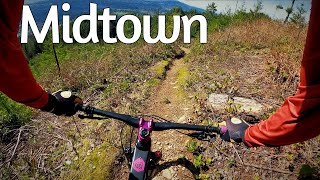
New entrance to Midtown and PNWheel is now open. Midtown (Right) and PNWheel (Left) will split about 100 yards into the trail. Midtown section that flows from the clear cut to near to Lake Marie Road.. This section of a trail was a reroute to the original Midtown. To continue down lower midtown make a right at the road and access the top of Uptown Funk that is on your left. Keep right after you drop in.

Traditionally Indigenous Territory

Recent Activity on Trail

Past Week
  • 0 rides
  •  
6 Months
  • 21 rides
  • 13 miles avg distance
All
  • 306 rides
  • Last: Jun 11, 2026
c1c2c3c4
January
February
March
April
May
June
July
August
September
October
November
December
update trails status or condition

Midtown (Upper) Trail Reports

statusdatedescription
Jan 10, 2026 @ 9:37am (America/Vancouver)
Jan 10, 2026
Dec 17, 2025 @ 1:04pm (America/Los_Angeles)
Dec 17, 2025
Dec 12, 2025 @ 12:57pm (America/Los_Angeles)
Dec 12, 2025
Voluntary Tokul Trail Closure - Flooding prevents access and landslide risks. Stay Home.
Oct 27, 2025 @ 9:50pm (America/Los_Angeles)
Oct 27, 2025
Oct 6, 2025 @ 9:34am (America/Los_Angeles)
Oct 6, 2025
A little overgrown at the beginning and through the clearcut portion. Completely rideable, but a little tight with some crowding from the brush.
more »
Status:
on Jan 10, 2026
Ideal
Avg: 3.81 (5 votes)
Your vote: 0

view (2,170)
close
3D
Trail Conditions
  • Unknown
  • Snow Groomed
  • Snow Packed
  • Snow Covered
  • Snow Cover Partial
  • Freeze/thaw Cycle
  • Icy
  • Prevalent Mud
  • Wet
  • Variable
  • Ideal
  • Dry
  • Very Dry
Trail Flow (Ridden Direction)
Trailforks scans users ridelogs to determine the most popular direction each trail is ridden. A good flowing trail network will have most trails flowing in a single direction according to their intension.
The colour categories are based on what percentage of riders are riding a trail in its intended direction.
  • > 96%
  • > 90%
  • > 80%
  • > 70%
  • > 50%
  • < 50%
  • bi-directional trail
  • no data
Trail Last Ridden
Trailforks scans ridelogs to determine the last time a trail was ridden.
  • < 2 days
  • < 1 week
  • < 2 weeks
  • < 1 month
  • < 6 months
  • > 6 months
Trail Ridden Direction
The intended direction a trail should be ridden.
  • Downhill Only
  • Downhill Primary
  • Both Directions
  • Uphill Primary
  • Uphill Only
  • One Direction
Contribute Details
Colors indicate trail is missing specified detail.
  • Description
  • Photos
  • Description & Photos
  • Videos
Trail Popularity ?
Trailforks scans ridelogs to determine which trails are ridden the most in the last 9 months. Trails are compared with nearby trails in the same city region with a possible 25 colour shades. Think of this as a heatmap, more rides = more kinetic energy = warmer colors.
  • most popular
  • popular
  • less popular
  • not popular
ATV/ORV/OHV Filter
Max Vehicle Width
inches
US Cell Coverage
Legend
cell carrier legend

Radar Time
Activity Recordings
Trailforks uses anonymized public activity data. ?
Activity Recordings
Trailforks uses anonymized public activity data. ?
Personal Heatmap
Activity Types
all / none
Options
2
Date range month
Winter Trails
Warning A routing network for winter maps does not exist. Selecting trails using the winter trails layer has been disabled.
Missing Trails
Most Popular
Least Popular
Trails are colored based on popularity. The more popular a trail is, the more red. Less popular trails trend towards green.
Jump Magnitude Heatmap
Heatmap of where riders jump on trails. Zoom in to see individual jumps, click circles to view jump details.
BC Backroad Status

Service Road Atlas is a free to use, community-driven service for viewing and creating reports on the numerous back-country service roads around B.C. and Alberta.

map legend
Slope Aspect
Direction the slope faces
Flat N NE E SE S SW W NW
Trails Deemphasized
Trails are shown in grey.
disable
Only show trails with no bike usage.
Enable
Suggested Layers
Based on selected activity type

    Save the current map location and zoom level as your default home location whenever this page is loaded.

    Save
        Directions to midtown-upper trailhead (47.568970, -121.852780)

        Photos

        2 more »
        44 |
        Nov 6, 2023 @ 7:08pm
        Nov 6, 2023
        40 |
        Feb 13, 2023 @ 7:34pm
        Feb 13, 2023

        Videos

        1 more »
        Midtown - Tokul MTB
        3:03 | 284 | May 15, 2022 , Fall City

        Routes with this trail

        6 miles 1,350 ft 10 Out & Back
        A shorter-distance loop of East Tokul, hitting , (lower) and all of Midtown.
        5 miles 923 ft 9
        and then cross over to midtown. This ride avoids the super technical of Tokul but adds the fun and workout.
        28 miles 5,691 ft 47 Point to Point
        A difficult long day in the saddle. Requires climbing skills and descending skills. Good Luck!

        4 Reviews & Comments


        We hope you've been enjoying Trailforks!

        Create a FREE account to view trail comments and much more.

        • By bedell99TF Pro C2S-FC & contributors
        • #239803 - 1,500 views

        Frequently Asked Questions About Midtown (Upper)

        Where is Midtown (Upper) located?
        Midtown (Upper) is located in Tokul East, Fall City, Washington, United States. It is part of the Tokul East trail network. The trailhead is located at coordinates 47.56897, -121.85278.
        How hard is Midtown (Upper)?
        Midtown (Upper) is rated as Blue difficulty. The average grade is 12.4%.
        What is the elevation gain for Midtown (Upper)?
        The trail has 54 m of elevation descent. The elevation ranges from 184 m to 238 m.
        Is Midtown (Upper) a point to point trail?
        Yes, Midtown (Upper) is a point to point trail. The direction is Downhill Only. The trail type is singletrack.

        Hit the Trail

        Open in App

        Get this trail on your phone instantly.
        open trail in app

        Download Trail

        Save to wishlist, Garmin & download.
        save the trail

        Find Related Routes

        Find routes and users activities that include this trail.
        find routes for this trail

        You must enter a description before submitting.