more stats
1,854 ft
Distance
-209 ft
Descent
00:04:43
Avg time
-209 ft
Altitude change
2,203 ft
Altitude min
2,412 ft
Altitude max
2,412 ft
Altitude start
2,201 ft
Altitude end
-11.3%
Grade
-31.3%
Grade max
-3.6%
Grade min
1,834 ft
Distance down
20 ft
Distance flat
00:04:43
Avg time

Missing Lynx Details

  • Activities
    • Mountain Bike
    • Winter Fat Bike
    • Hike
    • Trail Running
  • Riding Area
    Otway
    Prince George, British Columbia
  • Difficulty Rating
  • Local Popularity
    25 in Mountain Biking [+]
    • 5 in Trail Running
    • 100 in Hiking
  • Global Ranking
    #161147 in Mountain Biking [+]
    • #283726 in Trail Running
    • #30028 in Hiking
  • Trail Type
    Singletrack
  • Bike Type
    AM, XC, Fat
  • Direction
    Downhill Primary
    Popular Direction Shown
  • Climb Difficulty
    Double Black Diamond
  • Physical Rating
    Hard
  • Season
    April - Nov.
  • Dogs Allowed
    Yes
  • TTFs on Trail
    Bridge, Drop
  • Ride in Rain
    Yes

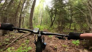
Starts of relatively easy but progressively gets steeper & more technical as it approaches the end of the trail. The last couple hundred metres are quite steep & technical.

Access Info

Trail starts at the junction of Treehugger & Broken Moose. Terminus is at the Dog Loop ski trail. Go left to return to Otway, look for Espresso on riders left a few hundred metres after leaving Missing Lynx.

This trail is unsanctioned.

Disclaimer

Trail is on private property

Recent Activity on Trail

Past Week
  • 0 rides
  •  
6 Months
  • 1 rides
  • 7 miles avg distance
All
  • 38 rides
  • Last: Apr 18, 2026
c1c2c3c4
January
February
March
April
May
June
July
August
September
October
November
December
update trails status or condition

Missing Lynx Trail Reports

statusdatedescription
Jan 1, 2025 @ 9:45am
Jan 1, 2025
Apr 27, 2024 @ 8:26am
Apr 27, 2024
reporter
Apr 16, 2024 @ 2:30pm
Apr 16, 2024
reporter
Jul 3, 2021 @ 4:56am
Jul 3, 2021
Most of the trail has been replaced by fireroad. Unrideable conditions for this and tree hugger. Or the trailforks map needs reworking to identify...
Apr 24, 2021 @ 1:32pm
Apr 24, 2021
Please stay off the trails until they dry out. Riding now, when they are partially frozen and muddy will destroy trails and make a lot of extra...
more »
Status:
on Jan 1, 2025
Snow Covered
Avg: 3.98 (1 votes)
Your vote: 0

view (179)
close
3D
Trail Conditions
  • Unknown
  • Snow Groomed
  • Snow Packed
  • Snow Covered
  • Snow Cover Partial
  • Freeze/thaw Cycle
  • Icy
  • Prevalent Mud
  • Wet
  • Variable
  • Ideal
  • Dry
  • Very Dry
Trail Flow (Ridden Direction)
Trailforks scans users ridelogs to determine the most popular direction each trail is ridden. A good flowing trail network will have most trails flowing in a single direction according to their intension.
The colour categories are based on what percentage of riders are riding a trail in its intended direction.
  • > 96%
  • > 90%
  • > 80%
  • > 70%
  • > 50%
  • < 50%
  • bi-directional trail
  • no data
Trail Last Ridden
Trailforks scans ridelogs to determine the last time a trail was ridden.
  • < 2 days
  • < 1 week
  • < 2 weeks
  • < 1 month
  • < 6 months
  • > 6 months
Trail Ridden Direction
The intended direction a trail should be ridden.
  • Downhill Only
  • Downhill Primary
  • Both Directions
  • Uphill Primary
  • Uphill Only
  • One Direction
Contribute Details
Colors indicate trail is missing specified detail.
  • Description
  • Photos
  • Description & Photos
  • Videos
Trail Popularity ?
Trailforks scans ridelogs to determine which trails are ridden the most in the last 9 months. Trails are compared with nearby trails in the same city region with a possible 25 colour shades. Think of this as a heatmap, more rides = more kinetic energy = warmer colors.
  • most popular
  • popular
  • less popular
  • not popular
ATV/ORV/OHV Filter
Max Vehicle Width
inches
US Cell Coverage
Legend
cell carrier legend

Radar Time
Activity Recordings
Trailforks uses anonymized public activity data. ?
Activity Recordings
Trailforks uses anonymized public activity data. ?
Personal Heatmap
Activity Types
all / none
Options
2
Date range month
Winter Trails
Warning A routing network for winter maps does not exist. Selecting trails using the winter trails layer has been disabled.
Missing Trails
Most Popular
Least Popular
Trails are colored based on popularity. The more popular a trail is, the more red. Less popular trails trend towards green.
Jump Magnitude Heatmap
Heatmap of where riders jump on trails. Zoom in to see individual jumps, click circles to view jump details.
BC Backroad Status

Service Road Atlas is a free to use, community-driven service for viewing and creating reports on the numerous back-country service roads around B.C. and Alberta.

map legend
Slope Aspect
Direction the slope faces
Flat N NE E SE S SW W NW
Trails Deemphasized
Trails are shown in grey.
disable
Only show trails with no bike usage.
Enable
Suggested Layers
Based on selected activity type

    Save the current map location and zoom level as your default home location whenever this page is loaded.

    Save
        Directions to missing-lynx trailhead (53.958090, -122.868600)

        Photos

        No photos have been added for Missing Lynx yet, add a photo.

        Videos

        1 more »
        MISSING LYNX
        4:16 | 223 | Aug 26, 2020 , Prince George

        Routes with this trail

        8 miles 1,254 ft 25
        Way out there!!!!!!!!!!!!!

        2 Reviews & Comments


        We hope you've been enjoying Trailforks!

        Create a FREE account to view trail comments and much more.

        Nearby Trails

        • #57842 - 1,549 views

        Frequently Asked Questions About Missing Lynx

        Where is Missing Lynx located?
        Missing Lynx is located in Otway, Prince George, British Columbia, Canada. It is part of the Otway trail network. The trailhead is located at coordinates 53.95809, -122.8686.
        How hard is Missing Lynx?
        Missing Lynx is rated as Black Diamond difficulty. The physical rating is Hard. The average grade is 11.3%. The climb difficulty is rated Double Black Diamond.
        What is the elevation gain for Missing Lynx?
        The trail has 209 ft of elevation descent. The elevation ranges from 2,203 ft to 2,412 ft.
        Is Missing Lynx a point to point trail?
        Missing Lynx is not a point to point trail. The direction is Downhill Primary. The trail type is singletrack.

        Hit the Trail

        Open in App

        Get this trail on your phone instantly.
        open trail in app

        Download Trail

        Save to wishlist, Garmin & download.
        save the trail

        Find Related Routes

        Find routes and users activities that include this trail.
        find routes for this trail

        You must enter a description before submitting.