more stats
2.1 miles
Distance
180 ft
Climb
-970 ft
Descent
00:23:03
Avg time
-787 ft
Altitude change
2,876 ft
Altitude min
3,774 ft
Altitude max
3,771 ft
Altitude start
2,982 ft
Altitude end
-7.1%
Grade
-50.1%
Grade max
42.1%
Grade min
3,041 ft
Distance climb
1 mile
Distance down
404 ft
Distance flat
00:23:03
Avg time

Moretó Details

  • Activities
    • Mountain Bike
    • E-Bike
    • Hike
    • Trail Running
  • Riding Area
  • Difficulty Rating
  • Local Popularity
    75 in Mountain Biking [+]
    • 65 in E-Biking
    • 90 in Trail Running
    • 5 in Hiking
  • Global Ranking
    #67328 in Mountain Biking [+]
    • #1645 in E-Biking
    • #35333 in Trail Running
    • #132932 in Hiking
  • Trail Type
    Singletrack
  • Bike Type
    AM, XC
  • Direction
    Downhill Primary
    Popular Direction Shown
  • Climb Difficulty
    Black Diamond
  • Physical Rating
    Moderate
  • Trail Visibility
    Sometimes hard to follow
  • Dogs Allowed
    Yes
  • eBike Allowed
    Yes up to Class 1
  • Land Owner
    Associació Lo Podall

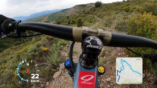
Sender que enllaça la pista de la Collada de Castellet amb el poble de Gurp sense perdre molta alçada. Es de terreny conglomerat amb molt bones vistes. Hi ha algun tram tècnic però molt asequible en general. Terreny salvatge Passa per la capçalera del barranc de Gurp per això en epoca estival ens podem creuar amb algun/a barranquista.
ESP: Trail que enlaza la pista de la Collada de Castellet con el pueblo de Gurp sin perder mucha altura. El terreno es de roca conglomerada que drena muy bien. Disfrutaremos de buenas vistas. Tiene algun paso técnico pero es asequible en general. Terreno salvaje que pasa por el inicio del Barranco de Gurp. Es por eso que en verano nos podemos cruzar con algun barranquista.

Local Trail Association

Recent Activity on Trail

Past Week
  • 0 rides
  •  
6 Months
  • 23 rides
  • 21 miles avg distance
All
  • 94 rides
  • Last: Jun 12, 2026
c1c2c3c4
January
February
March
April
May
June
July
August
September
October
November
December
update trails status or condition

Moretó Trail Reports

statusdatedescription
Apr 18, 2026 @ 10:28am (Europe/Andorra)
Apr 18, 2026
Recientemente limpiado. Estado perfecto
Mar 13, 2026 @ 10:52pm (Europe/Madrid)
Mar 13, 2026
reporter Acabat de desbrossar i s'han apartat les pedres més grans. Impecable!
Mar 7, 2026 @ 11:11am (Europe/Andorra)
Mar 7, 2026
J'adore, un peu excentré donc moins fréquenté, mais c'est un de mes favoris combiné avec llom
Oct 28, 2025 @ 4:52pm (Europe/Madrid)
Oct 28, 2025
Magnifique sentier avec de belles vues.
Sep 11, 2025 @ 10:04am
Sep 11, 2025
more »
Status:
on Apr 18, 2026
Ideal
Avg: 4.23 (12 votes)
Your vote: 0

view (638)
close
3D
Trail Conditions
  • Unknown
  • Snow Groomed
  • Snow Packed
  • Snow Covered
  • Snow Cover Partial
  • Freeze/thaw Cycle
  • Icy
  • Prevalent Mud
  • Wet
  • Variable
  • Ideal
  • Dry
  • Very Dry
Trail Flow (Ridden Direction)
Trailforks scans users ridelogs to determine the most popular direction each trail is ridden. A good flowing trail network will have most trails flowing in a single direction according to their intension.
The colour categories are based on what percentage of riders are riding a trail in its intended direction.
  • > 96%
  • > 90%
  • > 80%
  • > 70%
  • > 50%
  • < 50%
  • bi-directional trail
  • no data
Trail Last Ridden
Trailforks scans ridelogs to determine the last time a trail was ridden.
  • < 2 days
  • < 1 week
  • < 2 weeks
  • < 1 month
  • < 6 months
  • > 6 months
Trail Ridden Direction
The intended direction a trail should be ridden.
  • Downhill Only
  • Downhill Primary
  • Both Directions
  • Uphill Primary
  • Uphill Only
  • One Direction
Contribute Details
Colors indicate trail is missing specified detail.
  • Description
  • Photos
  • Description & Photos
  • Videos
Trail Popularity ?
Trailforks scans ridelogs to determine which trails are ridden the most in the last 9 months. Trails are compared with nearby trails in the same city region with a possible 25 colour shades. Think of this as a heatmap, more rides = more kinetic energy = warmer colors.
  • most popular
  • popular
  • less popular
  • not popular
ATV/ORV/OHV Filter
Max Vehicle Width
inches
US Cell Coverage
Legend
cell carrier legend

Radar Time
Activity Recordings
Trailforks uses anonymized public activity data. ?
Activity Recordings
Trailforks uses anonymized public activity data. ?
Personal Heatmap
Activity Types
all / none
Options
2
Date range month
Winter Trails
Warning A routing network for winter maps does not exist. Selecting trails using the winter trails layer has been disabled.
Missing Trails
Most Popular
Least Popular
Trails are colored based on popularity. The more popular a trail is, the more red. Less popular trails trend towards green.
Jump Magnitude Heatmap
Heatmap of where riders jump on trails. Zoom in to see individual jumps, click circles to view jump details.
BC Backroad Status

Service Road Atlas is a free to use, community-driven service for viewing and creating reports on the numerous back-country service roads around B.C. and Alberta.

map legend
Slope Aspect
Direction the slope faces
Flat N NE E SE S SW W NW
Trails Deemphasized
Trails are shown in grey.
disable
Only show trails with no bike usage.
Enable
Suggested Layers
Based on selected activity type

    Save the current map location and zoom level as your default home location whenever this page is loaded.

    Save
        Directions to moreto trailhead (42.232030, 0.865140)

        Photos

        5 more »
        89 |
        Sep 9, 2023 @ 11:53am
        Sep 9, 2023
        148 |
        Dec 15, 2020 @ 10:59am
        Dec 15, 2020
        183 |
        Nov 21, 2020 @ 9:14am
        Nov 21, 2020
        157 |
        Aug 13, 2020 @ 10:14pm
        Aug 13, 2020

        Videos

        1 more »
        Enduro por Tremp al borde del precipicio,...
        7:49 | 694 | May 17, 2021 , Tremp

        Routes with this trail

        5.0 23 miles 4,109 ft 12 Loop
        Sortim direcció Talarn i baixem el per després agafar la carretera que ens puja a Sta Engracia. Entrem a...
        26 miles 5,036 ft 5
        Pleta Verda, Bosc de Salas,

        2 Reviews & Comments


        We hope you've been enjoying Trailforks!

        Create a FREE account to view trail comments and much more.

        Frequently Asked Questions About Moretó

        Where is Moretó located?
        Moretó is located in Territori Lo Podall Tremp, Tremp, Spain. It is part of the Territori Lo Podall Tremp trail network. The trailhead is located at coordinates 42.23203, 0.86514.
        How hard is Moretó?
        Moretó is rated as Red difficulty. The physical rating is Moderate. The average grade is 7.1%. The climb difficulty is rated Black Diamond.
        What is the elevation gain for Moretó?
        Moretó has 180 ft of elevation gain. The trail has 970 ft of elevation descent. The elevation ranges from 2,876 ft to 3,774 ft.
        Is Moretó a point to point trail?
        Moretó is not a point to point trail. The direction is Downhill Primary. The trail type is singletrack.

        Hit the Trail

        Open in App

        Get this trail on your phone instantly.
        open trail in app

        Download Trail

        Save to wishlist, Garmin & download.
        save the trail

        Find Related Routes

        Find routes and users activities that include this trail.
        find routes for this trail

        You must enter a description before submitting.