

Open in App
Get this trail on your phone instantly.

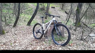
Singletrack prevalentemente sottobosco, abbastanza scorrevole con solo qualche tratto un po più impegnativo e qualche salto evitabile
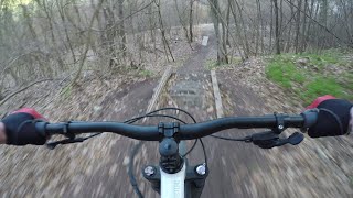
dopo la metà del trail a un certo punto si esce dal bosco e ci si trova in un campo, bisogna andare diritto e attraversarlo , di solito si vede comunque la traccia ( attenzione ad un solco di scolo a metà campo ), alla fine del campo si gira a sinistra e si vede una rampa in legno (evitabile), proseguire e poco dopo si vede la traccia che gira a sinistra e rientra nel bosco
Come gli altri trail della zona volendo si puo partire dal monte corniola (vedere trasferimento) per rendere il trail piu lungo oppure salendo si possono vedere i catrelli che indicano i vari trail
dopo la metà del trail a un certo punto si esce dal bosco e ci si trova in un campo, bisogna andare diritto e attraversarlo , di solito si vede comunque la traccia ( attenzione ad un solco di scolo a metà campo ), alla fine del campo si gira a sinistra e si vede una rampa in legno (evitabile), proseguire e poco dopo si vede la traccia che gira a sinistra e rientra nel bosco
| c1 | c2 | c3 | c4 |
|---|---|---|---|
January | February | March | April |
May | June | July | August |
September | October | November | December |

Service Road Atlas is a free to use, community-driven service for viewing and creating reports on the numerous back-country service roads around B.C. and Alberta.
Save the current map location and zoom level as your default home location whenever this page is loaded.
SaveWe hope you've been enjoying Trailforks!
Create a FREE account to view trail comments and much more.
You must enter a description before submitting.

