more stats
2,776 ft
Distance
4 ft
Climb
-315 ft
Descent
00:07:10
Avg time
-311 ft
Altitude change
1,424 ft
Altitude min
1,735 ft
Altitude max
1,735 ft
Altitude start
1,424 ft
Altitude end
-11.2%
Grade
-34.7%
Grade max
4.6%
Grade min
98 ft
Distance climb
2,431 ft
Distance down
243 ft
Distance flat
00:07:10
Avg time

Moving Target Details

  • Activities
    • Mountain Bike
    • Hike
    • Trail Running
  • Riding Area
    Kruger Mountain/Blue Lake/Kilpoola
    Osoyoos, British Columbia
  • Difficulty Rating
  • Local Popularity
    95 in Mountain Biking [+]
    • 5 in Trail Running
    • 5 in Hiking
  • Global Ranking
    #40499 in Mountain Biking [+]
    • #129683 in Trail Running
    • #46044 in Hiking
  • Trail Type
    Mixed
  • Bike Type
    DH, AM, XC, DJ
  • Physical Rating
    Moderate
  • Dogs Allowed
    Yes
  • TTFs on Trail
    Berm, Rock Garden

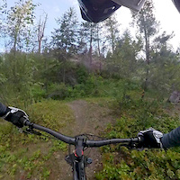
Moving Target is an Osoyoos classic that has now been downgraded in difficulty to Blue as the Original iconic features have been separated onto an optional black line called Gun Show. The fire burnt the old wooden features but they will be rebuilt bigger and better than ever

Access Info

Hwy 3, Old Richter Passage rd, Kruger Mtn Rd,

This trail is unsanctioned.

Recent Activity on Trail

Past Week
  • 0 rides
  •  
6 Months
  • 10 rides
  • 7 miles avg distance
All
  • 270 rides
  • Last: Jun 29, 2026
c1c2c3c4
January
February
March
April
May
June
July
August
September
October
November
December
update trails status or condition

Moving Target Trail Reports

statusdatedescription
Mar 20, 2026 @ 8:49pm (America/Vancouver)
Mar 20, 2026
Generally great shape. Large tree down on upper moving target, in a high speed section and not easy to see, just before the sidehill above the...
Oct 3, 2025 @ 3:46pm (America/Vancouver)
Oct 3, 2025
The Trail is a little soft up top and the middle and lower sections have been marked, trimmed and raked and it is running good.
Aug 11, 2025 @ 8:33am
Aug 11, 2025
Top is not really rideable in current state. Better to hit the or harder trails.
Jul 30, 2025 @ 3:48pm
Jul 30, 2025
Barely rideable at present. Trail is both very rutted-out and heavily overgrown in several sections, so unless you enjoy bushwhacking with your...
Jul 12, 2025 @ 2:51pm
Jul 12, 2025
reporter Water has stopped flowing but upper trail is badly damaged. Lower trail was great but sections starting to get overgrown again.
more »
Status:
on Mar 20, 2026
Ideal
Avg: 4 (14 votes)
Your vote: 0

view (654)
close
3D
Trail Conditions
  • Unknown
  • Snow Groomed
  • Snow Packed
  • Snow Covered
  • Snow Cover Partial
  • Freeze/thaw Cycle
  • Icy
  • Prevalent Mud
  • Wet
  • Variable
  • Ideal
  • Dry
  • Very Dry
Trail Flow (Ridden Direction)
Trailforks scans users ridelogs to determine the most popular direction each trail is ridden. A good flowing trail network will have most trails flowing in a single direction according to their intension.
The colour categories are based on what percentage of riders are riding a trail in its intended direction.
  • > 96%
  • > 90%
  • > 80%
  • > 70%
  • > 50%
  • < 50%
  • bi-directional trail
  • no data
Trail Last Ridden
Trailforks scans ridelogs to determine the last time a trail was ridden.
  • < 2 days
  • < 1 week
  • < 2 weeks
  • < 1 month
  • < 6 months
  • > 6 months
Trail Ridden Direction
The intended direction a trail should be ridden.
  • Downhill Only
  • Downhill Primary
  • Both Directions
  • Uphill Primary
  • Uphill Only
  • One Direction
Contribute Details
Colors indicate trail is missing specified detail.
  • Description
  • Photos
  • Description & Photos
  • Videos
Trail Popularity ?
Trailforks scans ridelogs to determine which trails are ridden the most in the last 9 months. Trails are compared with nearby trails in the same city region with a possible 25 colour shades. Think of this as a heatmap, more rides = more kinetic energy = warmer colors.
  • most popular
  • popular
  • less popular
  • not popular
ATV/ORV/OHV Filter
Max Vehicle Width
inches
US Cell Coverage
Legend
cell carrier legend

Radar Time
Activity Recordings
Trailforks uses anonymized public activity data. ?
Activity Recordings
Trailforks uses anonymized public activity data. ?
Personal Heatmap
Activity Types
all / none
Options
2
Date range month
Winter Trails
Warning A routing network for winter maps does not exist. Selecting trails using the winter trails layer has been disabled.
Missing Trails
Most Popular
Least Popular
Trails are colored based on popularity. The more popular a trail is, the more red. Less popular trails trend towards green.
Jump Magnitude Heatmap
Heatmap of where riders jump on trails. Zoom in to see individual jumps, click circles to view jump details.
BC Backroad Status

Service Road Atlas is a free to use, community-driven service for viewing and creating reports on the numerous back-country service roads around B.C. and Alberta.

map legend
Slope Aspect
Direction the slope faces
Flat N NE E SE S SW W NW
Trails Deemphasized
Trails are shown in grey.
disable
Only show trails with no bike usage.
Enable
Suggested Layers
Based on selected activity type

    Save the current map location and zoom level as your default home location whenever this page is loaded.

    Save
        Directions to moving-target trailhead (49.040380, -119.515040)

        Photos

        49 more »
        80 |
        Aug 29, 2022 @ 4:01am
        Aug 29, 2022
        67 |
        Jun 28, 2022 @ 9:50pm
        Jun 28, 2022
        85 |
        Jun 28, 2022 @ 9:48pm
        Jun 28, 2022
        85 |
        Apr 18, 2022 @ 1:00pm
        Apr 18, 2022

        Videos

        2 more »
        Moving Target
        289 | Sep 1, 2020 , Osoyoos
        2:05 | 385 | Jun 22, 2019 , Osoyoos

        Routes with this trail

        4 miles 203 ft 4 Point to Point
        Strawberry Creeks most common Intermediate Ride, with a great mix of flow, and easy technical features,...

        6 Reviews & Comments


        We hope you've been enjoying Trailforks!

        Create a FREE account to view trail comments and much more.

        • #22441 - 7,443 views

        Frequently Asked Questions About Moving Target

        Where is Moving Target located?
        Moving Target is located in Kruger Mountain/Blue Lake/Kilpoola, Osoyoos, British Columbia, Canada. It is part of the Kruger Mountain/Blue Lake/Kilpoola trail network. The trailhead is located at coordinates 49.04038, -119.51504.
        How hard is Moving Target?
        Moving Target is rated as Blue difficulty. The physical rating is Moderate. The average grade is 11.2%.
        What is the elevation gain for Moving Target?
        Moving Target has 4 ft of elevation gain. The trail has 315 ft of elevation descent. The elevation ranges from 1,424 ft to 1,735 ft.
        How long is Moving Target?
        Moving Target is 2,776 ft long. The trail type is mixed.

        Hit the Trail

        Open in App

        Get this trail on your phone instantly.
        open trail in app

        Download Trail

        Save to wishlist, Garmin & download.
        save the trail

        Find Related Routes

        Find routes and users activities that include this trail.
        find routes for this trail

        You must enter a description before submitting.