more stats
4.2 miles
Distance
396 ft
Climb
-2,706 ft
Descent
00:51:33
Avg time
-2,310 ft
Altitude change
1,610 ft
Altitude min
3,922 ft
Altitude max
3,920 ft
Altitude start
1,610 ft
Altitude end
-10.322%
Grade
-50.982%
Grade max
35.901%
Grade min
4,422 ft
Distance climb
3 miles
Distance down
539 ft
Distance flat
00:51:33
Avg time

Multiworld Details

  • Activities
    • Mountain Bike
    • Hike
    • Trail Running
  • Riding Area
  • Difficulty Rating
  • Voted Difficulty
    Blue (3 votes)
  • Local Popularity
    80 in Mountain Biking [+]
    • 5 in Trail Running
    • 5 in Hiking
  • Global Ranking
    #27043 in Mountain Biking [+]
    • #124386 in Trail Running
    • #117837 in Hiking
  • Trail Type
    Singletrack
  • Bike Type
    AM
  • Direction
    Downhill Primary
    Popular Direction Shown
  • Climb Difficulty
    Blue
  • Physical Rating
    Moderate
  • Season
    April-October
  • Dogs Allowed
    Yes

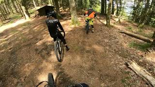
Traverse from Markstein to Treh, then down to the valley traversing different kind of forest, terrain and type of trail. A good mix to have an overview of what the region has to offer.
A little climb in the middle to a viewpoint worth the effort

Recent Activity on Trail

Past Week
  • 1 rides
  • 5 miles average
6 Months
  • 3 rides
  • 25 miles avg distance
All
  • 29 rides
  • Last: Jun 10, 2026
c1c2c3c4
January
February
March
April
May
June
July
August
September
October
November
December
update trails status or condition

Multiworld Trail Reports

statusdatedescription
May 10, 2026 @ 3:40pm (Europe/Paris)
May 10, 2026
excellent trail comme beaucoup dans la région, ludique fun avec petite section technique en finale. passage de portillon un peut seré, mais sa...
Jun 23, 2025 @ 3:54am
Jun 23, 2025
Some fallen trees, otherwise good condition.
Jun 25, 2024 @ 9:04am
Jun 25, 2024
May 11, 2024 @ 7:25am
May 11, 2024
Fine conditions atm. Lots of loose rocks.
Sep 6, 2023 @ 4:00pm
Sep 6, 2023
Only a couple of fallen trees and 3 cattle fences to overlap, one uphill where you have to walk, but all is worth this wonderful trail!
more »
Status:
on May 10, 2026
Ideal
Avg: 4.39 (27 votes)
Your vote: 0

view (103)
close
3D
Trail Conditions
  • Unknown
  • Snow Groomed
  • Snow Packed
  • Snow Covered
  • Snow Cover Partial
  • Freeze/thaw Cycle
  • Icy
  • Prevalent Mud
  • Wet
  • Variable
  • Ideal
  • Dry
  • Very Dry
Trail Flow (Ridden Direction)
Trailforks scans users ridelogs to determine the most popular direction each trail is ridden. A good flowing trail network will have most trails flowing in a single direction according to their intension.
The colour categories are based on what percentage of riders are riding a trail in its intended direction.
  • > 96%
  • > 90%
  • > 80%
  • > 70%
  • > 50%
  • < 50%
  • bi-directional trail
  • no data
Trail Last Ridden
Trailforks scans ridelogs to determine the last time a trail was ridden.
  • < 2 days
  • < 1 week
  • < 2 weeks
  • < 1 month
  • < 6 months
  • > 6 months
Trail Ridden Direction
The intended direction a trail should be ridden.
  • Downhill Only
  • Downhill Primary
  • Both Directions
  • Uphill Primary
  • Uphill Only
  • One Direction
Contribute Details
Colors indicate trail is missing specified detail.
  • Description
  • Photos
  • Description & Photos
  • Videos
Trail Popularity ?
Trailforks scans ridelogs to determine which trails are ridden the most in the last 9 months. Trails are compared with nearby trails in the same city region with a possible 25 colour shades. Think of this as a heatmap, more rides = more kinetic energy = warmer colors.
  • most popular
  • popular
  • less popular
  • not popular
ATV/ORV/OHV Filter
Max Vehicle Width
inches
US Cell Coverage
Legend
cell carrier legend

Radar Time
Activity Recordings
Trailforks uses anonymized public activity data. ?
Activity Recordings
Trailforks uses anonymized public activity data. ?
Personal Heatmap
Activity Types
all / none
Options
2
Date range month
Winter Trails
Warning A routing network for winter maps does not exist. Selecting trails using the winter trails layer has been disabled.
Missing Trails
Most Popular
Least Popular
Trails are colored based on popularity. The more popular a trail is, the more red. Less popular trails trend towards green.
Jump Magnitude Heatmap
Heatmap of where riders jump on trails. Zoom in to see individual jumps, click circles to view jump details.
BC Backroad Status

Service Road Atlas is a free to use, community-driven service for viewing and creating reports on the numerous back-country service roads around B.C. and Alberta.

map legend
Slope Aspect
Direction the slope faces
Flat N NE E SE S SW W NW
Trails Deemphasized
Trails are shown in grey.
disable
Only show trails with no bike usage.
Enable
Suggested Layers
Based on selected activity type

    Save the current map location and zoom level as your default home location whenever this page is loaded.

    Save
        Directions to multiworld trailhead (47.923690, 7.028310)

        Photos

        18 more »
        423 |
        Nov 10, 2019 @ 9:44am
        Nov 10, 2019
        575 |
        Sep 3, 2019 @ 2:42am
        Sep 3, 2019
        364 |
        Aug 30, 2019 @ 12:53pm
        Aug 30, 2019
        386 |
        Aug 30, 2019 @ 12:52pm
        Aug 30, 2019

        Videos

        2 more »
        VTT trail Vosges Markstein #Multiworld #trailforks
        27:00 | 377 | Aug 26, 2023 , Kruth
        vtt kruth single ferme du treh
        12:32 | 297 | Mar 9, 2023 , Kruth

        Routes with this trail

        32 miles 7,563 ft 10
        Bike & Beer Saturday.....

        14 Reviews & Comments


        We hope you've been enjoying Trailforks!

        Create a FREE account to view trail comments and much more.

        Nearby Trails

        • By loizorider & contributors
        • #42509 - 4,477 views

        Frequently Asked Questions About Multiworld

        Where is Multiworld located?
        Multiworld is located in Kruth, France. It is part of the Kruth trail network. The trailhead is located at coordinates 47.92369, 7.02831.
        How hard is Multiworld?
        Multiworld is rated as Blue difficulty. The physical rating is Moderate. The average grade is 10.322%. The climb difficulty is rated Blue.
        What is the elevation gain for Multiworld?
        Multiworld has 396 ft of elevation gain. The trail has 2,706 ft of elevation descent. The elevation ranges from 1,610 ft to 3,922 ft.
        Is Multiworld a point to point trail?
        Multiworld is not a point to point trail. The direction is Downhill Primary. The trail type is singletrack.

        Hit the Trail

        Open in App

        Get this trail on your phone instantly.
        open trail in app

        Download Trail

        Save to wishlist, Garmin & download.
        save the trail

        Find Related Routes

        Find routes and users activities that include this trail.
        find routes for this trail

        You must enter a description before submitting.