more stats
2,352 ft
Distance
27 ft
Climb
-292 ft
Descent
00:06:27
Avg time
-263 ft
Altitude change
688 ft
Altitude min
980 ft
Altitude max
980 ft
Altitude start
719 ft
Altitude end
-11.2%
Grade
-40.9%
Grade max
9.7%
Grade min
443 ft
Distance climb
1,857 ft
Distance down
52 ft
Distance flat
00:06:27
Avg time

Nut Cracker Details

  • Activities
    • Mountain Bike
    • E-Bike
  • Riding Area
    Tamihi (Chilliwack River)
    Chilliwack, British Columbia
  • Difficulty Rating
  • Local Popularity
    85 in Mountain Biking [+]
    • 85 in E-Biking
  • Global Ranking
    #65365 in Mountain Biking [+]
    • #37857 in E-Biking
  • Trail Type
    Singletrack
  • Bike Type
    DH, AM
  • Direction
    Downhill Only
    Popular Direction Shown
  • Climb Difficulty
    Black Diamond
  • Physical Rating
    Moderate
  • Trail Visibility
    Sometimes hard to follow
  • Dogs Allowed
    Yes
  • eBike Allowed
  • TTFs on Trail
    Skinny, Teeter Totter
  • Land Owner
    Dual Sport BC

No community description for Nut Cracker trail has been added yet!

AI Generated Description

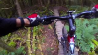
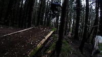
Nut Cracker is a highly rated 717 m popular black diamond difficulty singletrack trail located near Chilliwack British Columbia. This mountain bike primary trail can be used downhill only and has a moderate overall physical rating with a 8 m black diamond climb. It features skinny and teeter totter. Trail visibility is sometimes hard to follow. On average it takes 6 minutes to complete this trail.

Access Info

New trail head further up than current mapping shows (Oct '14). Go up to the 3 way fork and make a left. Look for trail head cutting back and down maybe 100m in (across from moto fall line trail on right). After first section make a left at road and follow around the bend to find the original beginning.

This trail is unsanctioned.

Traditionally Indigenous Territory

Recent Activity on Trail

Past Week
  • 1 rides
  • 7 miles average
6 Months
  • 4 rides
  • 8 miles avg distance
All
  • 46 rides
  • Last: Jun 28, 2026
c1c2c3c4
January
February
March
April
May
June
July
August
September
October
November
December
update trails status or condition

Nut Cracker Trail Reports

Status:
on Jun 16, 2026
Ideal
Avg: 4.21 (8 votes)
Your vote: 0

view (665)
close
3D
Trail Conditions
  • Unknown
  • Snow Groomed
  • Snow Packed
  • Snow Covered
  • Snow Cover Partial
  • Freeze/thaw Cycle
  • Icy
  • Prevalent Mud
  • Wet
  • Variable
  • Ideal
  • Dry
  • Very Dry
Trail Flow (Ridden Direction)
Trailforks scans users ridelogs to determine the most popular direction each trail is ridden. A good flowing trail network will have most trails flowing in a single direction according to their intension.
The colour categories are based on what percentage of riders are riding a trail in its intended direction.
  • > 96%
  • > 90%
  • > 80%
  • > 70%
  • > 50%
  • < 50%
  • bi-directional trail
  • no data
Trail Last Ridden
Trailforks scans ridelogs to determine the last time a trail was ridden.
  • < 2 days
  • < 1 week
  • < 2 weeks
  • < 1 month
  • < 6 months
  • > 6 months
Trail Ridden Direction
The intended direction a trail should be ridden.
  • Downhill Only
  • Downhill Primary
  • Both Directions
  • Uphill Primary
  • Uphill Only
  • One Direction
Contribute Details
Colors indicate trail is missing specified detail.
  • Description
  • Photos
  • Description & Photos
  • Videos
Trail Popularity ?
Trailforks scans ridelogs to determine which trails are ridden the most in the last 9 months. Trails are compared with nearby trails in the same city region with a possible 25 colour shades. Think of this as a heatmap, more rides = more kinetic energy = warmer colors.
  • most popular
  • popular
  • less popular
  • not popular
ATV/ORV/OHV Filter
Max Vehicle Width
inches
US Cell Coverage
Legend
cell carrier legend

Radar Time
Activity Recordings
Trailforks uses anonymized public activity data. ?
Activity Recordings
Trailforks uses anonymized public activity data. ?
Personal Heatmap
Activity Types
all / none
Options
2
Date range month
Winter Trails
Warning A routing network for winter maps does not exist. Selecting trails using the winter trails layer has been disabled.
Missing Trails
Most Popular
Least Popular
Trails are colored based on popularity. The more popular a trail is, the more red. Less popular trails trend towards green.
Jump Magnitude Heatmap
Heatmap of where riders jump on trails. Zoom in to see individual jumps, click circles to view jump details.
BC Backroad Status

Service Road Atlas is a free to use, community-driven service for viewing and creating reports on the numerous back-country service roads around B.C. and Alberta.

map legend
Slope Aspect
Direction the slope faces
Flat N NE E SE S SW W NW
Trails Deemphasized
Trails are shown in grey.
disable
Only show trails with no bike usage.
Enable
Suggested Layers
Based on selected activity type

    Save the current map location and zoom level as your default home location whenever this page is loaded.

    Save
        Directions to nut-cracker trailhead (49.064460, -121.829430)

        Photos

        8 more »
        64 |
        Jul 4, 2023 @ 2:23pm
        Jul 4, 2023
        672 |
        Nov 17, 2017 @ 7:29pm
        Nov 17, 2017
        304 |
        Nov 17, 2017 @ 7:29pm
        Nov 17, 2017
        565 |
        Oct 19, 2015 @ 9:34am
        Oct 19, 2015

        Videos

        5 more »
        Nut Cracker with BCpov
        763 | Apr 27, 2017 , Chilliwack
        Nut Cracker, Aug 3, 2016
        509 | Aug 5, 2016 , Chilliwack
        Drones and Bikes #3 Tamihi (Chilliwack River)
        11:55 | 155 | Oct 12, 2018 , Chilliwack
        Nut Cracker - Tamihi Creek
        0:42 | 212 | Mar 21, 2018 , Chilliwack

        Routes with this trail

        1.0 74 miles 10,766 ft 34 Loop
        Route for the Valley (Merritt) Crown - Full Throne. This route was drafted by Ricky Federau to take...
        6 miles 1,301 ft 16 Point to Point Race
        2018 Chilliwack FIVER #2: Tamihi Staging: Meet at the Tamahi Staging Area for 5:30 pm. Registration will...

        2 Reviews & Comments


        We hope you've been enjoying Trailforks!

        Create a FREE account to view trail comments and much more.

        • #2252 - 3,935 views

        Frequently Asked Questions About Nut Cracker

        Where is Nut Cracker located?
        Nut Cracker is located in Tamihi (Chilliwack River), Chilliwack, British Columbia, Canada. It is part of the Tamihi (Chilliwack River) trail network. The trailhead is located at coordinates 49.06446, -121.82943.
        How hard is Nut Cracker?
        Nut Cracker is rated as Black Diamond difficulty. The physical rating is Moderate. The average grade is 11.2%. The climb difficulty is rated Black Diamond.
        What is the elevation gain for Nut Cracker?
        Nut Cracker has 27 ft of elevation gain. The trail has 292 ft of elevation descent. The elevation ranges from 688 ft to 980 ft.
        Is Nut Cracker a point to point trail?
        Yes, Nut Cracker is a point to point trail. The direction is Downhill Only. The trail type is singletrack.

        Hit the Trail

        Open in App

        Get this trail on your phone instantly.
        open trail in app

        Download Trail

        Save to wishlist, Garmin & download.
        save the trail

        Find Related Routes

        Find routes and users activities that include this trail.
        find routes for this trail

        You must enter a description before submitting.