more stats
1,352 ft
Distance
-107 ft
Descent
00:03:19
Avg time
-110 ft
Altitude change
349 ft
Altitude min
459 ft
Altitude max
459 ft
Altitude start
348 ft
Altitude end
-8.1%
Grade
-22.5%
Grade max
-1.2%
Grade min
1,352 ft
Distance down
00:03:19
Avg time

Old Sam Details

  • Activities
    • Mountain Bike
    • Hike
    • Trail Running
  • Riding Area
    White Hills
    St. John's, Newfoundland
  • Difficulty Rating
  • Voted Difficulty
    Double Black Diamond (2 votes)
  • Local Popularity
    55 in Mountain Biking [+]
    • 5 in Trail Running
    • 85 in Hiking
  • Global Ranking
    #92257 in Mountain Biking [+]
    • #256653 in Trail Running
    • #57430 in Hiking
  • Trail Type
    Singletrack
  • Bike Type
    DH, AM
  • Direction
    Downhill Only
    Popular Direction Shown
  • Physical Rating
    Moderate
  • Trail Visibility
    Always easy to follow
  • Dogs Allowed
    Yes
  • Year Opened
    2016

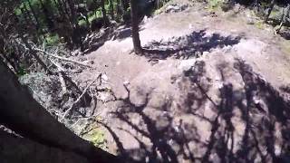
Start off with a couple quick sections of small, rocky descents. Coming to a quick 90 right, you'll then be faced with a larger steep descent into a less steep rocky section. This curves into another moderate rock race. Once at the bottom, there's a couple of quick climbs and tight turns to keep you on your toes, into a rooty run-out back onto OGXC

Access Info

Access from Outer Subnet Trail

This trail is unsanctioned.

Traditionally Indigenous Territory

Recent Activity on Trail

Past Week
  • 0 rides
  •  
6 Months
  • 0 rides
  •  
All
  • 209 rides
  • Last: May 10, 2026
c1c2c3c4
January
February
March
April
May
June
July
August
September
October
November
December
update trails status or condition

Old Sam Trail Reports

statusdatedescription
Mar 16, 2026 @ 4:23pm (America/St_Johns)
Mar 16, 2026
reporter Major erosion (major ruts or slumping, large boulders and roots exposed due to erosion). Multiple large trees down. Requires rerouting and major...
Sep 13, 2023 @ 4:55pm
Sep 13, 2023
Several downed trees after the DH portion. Good sight line to spot them ahead of time, but if they fall much lower they'll block the path.
Jun 17, 2021 @ 3:39pm
Jun 17, 2021
Great conditions, get out and ride!
May 21, 2021 @ 10:06am
May 21, 2021
reporter
Apr 24, 2021 @ 5:00am
Apr 24, 2021
reporter White Hills is open for the season! Any soft area try to go light or walk through. Any areas that are new construction and are still soft, turn...
more »
Status:
on Mar 16, 2026
Avg: 4.32 (6 votes)
Your vote: 0

view (2,210)
close
3D
Trail Conditions
  • Unknown
  • Snow Groomed
  • Snow Packed
  • Snow Covered
  • Snow Cover Partial
  • Freeze/thaw Cycle
  • Icy
  • Prevalent Mud
  • Wet
  • Variable
  • Ideal
  • Dry
  • Very Dry
Trail Flow (Ridden Direction)
Trailforks scans users ridelogs to determine the most popular direction each trail is ridden. A good flowing trail network will have most trails flowing in a single direction according to their intension.
The colour categories are based on what percentage of riders are riding a trail in its intended direction.
  • > 96%
  • > 90%
  • > 80%
  • > 70%
  • > 50%
  • < 50%
  • bi-directional trail
  • no data
Trail Last Ridden
Trailforks scans ridelogs to determine the last time a trail was ridden.
  • < 2 days
  • < 1 week
  • < 2 weeks
  • < 1 month
  • < 6 months
  • > 6 months
Trail Ridden Direction
The intended direction a trail should be ridden.
  • Downhill Only
  • Downhill Primary
  • Both Directions
  • Uphill Primary
  • Uphill Only
  • One Direction
Contribute Details
Colors indicate trail is missing specified detail.
  • Description
  • Photos
  • Description & Photos
  • Videos
Trail Popularity ?
Trailforks scans ridelogs to determine which trails are ridden the most in the last 9 months. Trails are compared with nearby trails in the same city region with a possible 25 colour shades. Think of this as a heatmap, more rides = more kinetic energy = warmer colors.
  • most popular
  • popular
  • less popular
  • not popular
ATV/ORV/OHV Filter
Max Vehicle Width
inches
US Cell Coverage
Legend
cell carrier legend

Radar Time
Activity Recordings
Trailforks uses anonymized public activity data. ?
Activity Recordings
Trailforks uses anonymized public activity data. ?
Personal Heatmap
Activity Types
all / none
Options
2
Date range month
Winter Trails
Warning A routing network for winter maps does not exist. Selecting trails using the winter trails layer has been disabled.
Missing Trails
Most Popular
Least Popular
Trails are colored based on popularity. The more popular a trail is, the more red. Less popular trails trend towards green.
Jump Magnitude Heatmap
Heatmap of where riders jump on trails. Zoom in to see individual jumps, click circles to view jump details.
BC Backroad Status

Service Road Atlas is a free to use, community-driven service for viewing and creating reports on the numerous back-country service roads around B.C. and Alberta.

map legend
Slope Aspect
Direction the slope faces
Flat N NE E SE S SW W NW
Trails Deemphasized
Trails are shown in grey.
disable
Only show trails with no bike usage.
Enable
Suggested Layers
Based on selected activity type

    Save the current map location and zoom level as your default home location whenever this page is loaded.

    Save
        Directions to old-sam trailhead (47.595780, -52.676220)

        Photos

        12 more »
        86 |
        Jul 26, 2022 @ 12:26pm
        Jul 26, 2022
        90 |
        Jul 17, 2022 @ 8:57am
        Jul 17, 2022
        179 |
        Dec 15, 2020 @ 10:03am
        Dec 15, 2020
        199 |
        Sep 4, 2020 @ 2:30am
        Sep 4, 2020

        Videos

        2 more »
        Old Sam
        7:18 | 548 | Oct 17, 2021 , St. John's
        Old Sam - White Hills, St. Johns, NL - 8JUL2020
        924 | Jul 8, 2020 , St. John's

        Routes with this trail

        7 miles 1,089 ft 10
        Good route to take in the hardest trails in White Hills
        10 miles 1,448 ft 12
        Route to take in some of the best downhill sections
        8 miles 1,083 ft 14
        Status of trails in White Hills as of January 24, 2021 for usage by fat bikes and trail runners.

        1 Review & Comments


        We hope you've been enjoying Trailforks!

        Create a FREE account to view trail comments and much more.

        Nearby Trails

        • #75719 - 2,265 views

        Frequently Asked Questions About Old Sam

        Where is Old Sam located?
        Old Sam is located in White Hills, St. John's, Newfoundland, Canada. It is part of the White Hills trail network. The trailhead is located at coordinates 47.59578, -52.67622.
        How hard is Old Sam?
        Old Sam is rated as Black Diamond difficulty. The physical rating is Moderate. The average grade is 8.1%.
        What is the elevation gain for Old Sam?
        The trail has 107 ft of elevation descent. The elevation ranges from 349 ft to 459 ft.
        Is Old Sam a point to point trail?
        Yes, Old Sam is a point to point trail. The direction is Downhill Only. The trail type is singletrack.

        Hit the Trail

        Open in App

        Get this trail on your phone instantly.
        open trail in app

        Download Trail

        Save to wishlist, Garmin & download.
        save the trail

        Find Related Routes

        Find routes and users activities that include this trail.
        find routes for this trail

        You must enter a description before submitting.