
Open in App
Get this trail on your phone instantly.

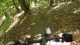
Ten singletrack wije się po wąskiej bocznej grani. Ma równe, gładkie podłoże i jest niezwykle przyjemny w jeździe. Kończy się ciekawym średnio stromym zjazdem przy skarpie. Tuż przed końcówka znajduje się nieczynny podziemny zbiornik wody, którego mała nadbudówka jest widoczna z singla.
This trail is unsanctioned.
| c1 | c2 | c3 | c4 |
|---|---|---|---|
January | February | March | April |
May | June | July | August |
September | October | November | December |

Service Road Atlas is a free to use, community-driven service for viewing and creating reports on the numerous back-country service roads around B.C. and Alberta.
Save the current map location and zoom level as your default home location whenever this page is loaded.
SaveWe hope you've been enjoying Trailforks!
Create a FREE account to view trail comments and much more.
You must enter a description before submitting.

