more stats
1,234 ft
Distance
-109 ft
Descent
879 ft
High Point
-109 ft
Altitude change
770 ft
Altitude min
879 ft
Altitude start
771 ft
Altitude end
-8.8%
Grade
-28.4%
Grade max
968 ft
Distance down
266 ft
Distance flat

Orophile Details

  • Activities
    • Mountain Bike
    • E-Bike
  • Riding Area
  • Difficulty Rating
  • Local Popularity
    70 in Mountain Biking [+]
    • 5 in E-Biking
  • Trail Type
    Singletrack
  • Bike Type
    DH, AM, XC
  • Direction
    Downhill Only[+]
    • Downhill Only for E-Biking
  • Physical Rating
    Moderate
  • Trail Visibility
    Always easy to follow
  • eBike Allowed
    Yes up to Class 1
  • TTFs on Trail
    Berm, Drop, Jump, Gap Jump
  • Year Opened
    2025
  • Land Owner
    MTO

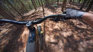
Once you drop in you don't need to pedal until you reach the firebreak.

Just a bit of flow and a couple jumps.

From the firebreak it gets a bit flatter until the last short flow section begins.

Non of the jumps are rollable. If you can't jump it please don't roll it and ruin the lip.

This is a MTB only trail
No runners, hikers or dog walkers please.

Take caution when exiting onto the road.

Drop straight into Dream On for a longer segment.

Access Info

MTO permit required.

Disclaimer

Look before you leap.

Trail Supporters

Recent Activity on Trail

Past Week
  • 0 rides
  •  
6 Months
  • 0 rides
  •  
All
  • 7 rides
  • Last: Jul 1, 2026
c1c2c3c4
January
February
March
April
May
June
July
August
September
October
November
December
update trails status or condition

Orophile Trail Reports

Status:
on May 10, 2026
Avg: 4.13 (1 votes)
Your vote: 0

view (21)
close
3D
Trail Conditions
  • Unknown
  • Snow Groomed
  • Snow Packed
  • Snow Covered
  • Snow Cover Partial
  • Freeze/thaw Cycle
  • Icy
  • Prevalent Mud
  • Wet
  • Variable
  • Ideal
  • Dry
  • Very Dry
Trail Flow (Ridden Direction)
Trailforks scans users ridelogs to determine the most popular direction each trail is ridden. A good flowing trail network will have most trails flowing in a single direction according to their intension.
The colour categories are based on what percentage of riders are riding a trail in its intended direction.
  • > 96%
  • > 90%
  • > 80%
  • > 70%
  • > 50%
  • < 50%
  • bi-directional trail
  • no data
Trail Last Ridden
Trailforks scans ridelogs to determine the last time a trail was ridden.
  • < 2 days
  • < 1 week
  • < 2 weeks
  • < 1 month
  • < 6 months
  • > 6 months
Trail Ridden Direction
The intended direction a trail should be ridden.
  • Downhill Only
  • Downhill Primary
  • Both Directions
  • Uphill Primary
  • Uphill Only
  • One Direction
Contribute Details
Colors indicate trail is missing specified detail.
  • Description
  • Photos
  • Description & Photos
  • Videos
Trail Popularity ?
Trailforks scans ridelogs to determine which trails are ridden the most in the last 9 months. Trails are compared with nearby trails in the same city region with a possible 25 colour shades. Think of this as a heatmap, more rides = more kinetic energy = warmer colors.
  • most popular
  • popular
  • less popular
  • not popular
ATV/ORV/OHV Filter
Max Vehicle Width
inches
US Cell Coverage
Legend
cell carrier legend

Radar Time
Activity Recordings
Trailforks uses anonymized public activity data. ?
Activity Recordings
Trailforks uses anonymized public activity data. ?
Personal Heatmap
Activity Types
all / none
Options
2
Date range month
Winter Trails
Warning A routing network for winter maps does not exist. Selecting trails using the winter trails layer has been disabled.
Missing Trails
Most Popular
Least Popular
Trails are colored based on popularity. The more popular a trail is, the more red. Less popular trails trend towards green.
Jump Magnitude Heatmap
Heatmap of where riders jump on trails. Zoom in to see individual jumps, click circles to view jump details.
BC Backroad Status

Service Road Atlas is a free to use, community-driven service for viewing and creating reports on the numerous back-country service roads around B.C. and Alberta.

map legend
Slope Aspect
Direction the slope faces
Flat N NE E SE S SW W NW
Trails Deemphasized
Trails are shown in grey.
disable
Only show trails with no bike usage.
Enable
Suggested Layers
Based on selected activity type

    Save the current map location and zoom level as your default home location whenever this page is loaded.

    Save
        Directions to orophile trailhead (-34.000400, 23.045280)

        Photos

        4 more »
        38 |
        Jan 14, 2026 @ 11:58am
        Jan 14, 2026
        35 |
        Jan 14, 2026 @ 11:58am
        Jan 14, 2026
        34 |
        Jan 14, 2026 @ 11:58am
        Jan 14, 2026
        119 |
        Dec 8, 2025 @ 4:14am
        Dec 8, 2025

        Videos

        1 more »
        Knysna Enduro Trails | Orophile
        0:01 | 28 | Apr 15, 2026 , Knysna

        Routes with this trail

        16 miles 2,048 ft 29 Race
        NOTE: This is the provisional Race Route. The KNYSNA ENDURO returns this year as part of the Knysna Cycle...

        Reviews / Comments

        No reviews yet, be the first to write a review or ask a question.
        Use trail reports to comment on trail conditions.


        We hope you've been enjoying Trailforks!

        Create a FREE account to view trail comments and much more.

        • By kaasmanmtbTF Pro & contributors
        • #855081 - 306 views

        Frequently Asked Questions About Orophile

        Where is Orophile located?
        Orophile is located in MTO Concordia Contours, Knysna, South Africa. It is part of the MTO Concordia Contours trail network. The trailhead is located at coordinates -34.0004, 23.04528.
        How hard is Orophile?
        Orophile is rated as Black Diamond difficulty. The physical rating is Moderate. The average grade is 8.8%.
        What is the elevation gain for Orophile?
        The trail has 33 m of elevation descent. The elevation ranges from 235 m to 268 m.
        Is Orophile a point to point trail?
        Yes, Orophile is a point to point trail. The direction is Downhill Only. The trail type is singletrack.

        Hit the Trail

        Open in App

        Get this trail on your phone instantly.
        open trail in app

        Download Trail

        Save to wishlist, Garmin & download.
        save the trail

        Find Related Routes

        Find routes and users activities that include this trail.
        find routes for this trail

        You must enter a description before submitting.