


Open in App
Get this trail on your phone instantly.

This was built as a connector trail from Value Added to Two Stroke. Also works as a good warm up if heading to Larvacide.
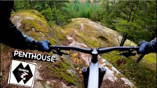
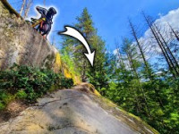
At the top, there are three different lines. The left-hand trail - is the least popular. The middle trail is the mainline for riders looking for a single black slab. To the right in the woods is a double black line (signed) that requires a 13-foot drop to a slab transition.
There is also an easier line 1/2 way down that sneaks through the forest on the right. This avoids the sting of the last move on the slab.
| c1 | c2 | c3 | c4 |
|---|---|---|---|
January | February | March | April |
May | June | July | August |
September | October | November | December |

Service Road Atlas is a free to use, community-driven service for viewing and creating reports on the numerous back-country service roads around B.C. and Alberta.
Save the current map location and zoom level as your default home location whenever this page is loaded.
Save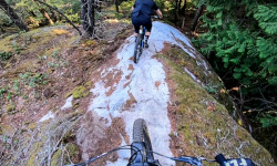
We hope you've been enjoying Trailforks!
Create a FREE account to view trail comments and much more.
You must enter a description before submitting.

