more stats
2,103 ft
Distance
-217 ft
Descent
00:04:56
Avg time
-217 ft
Altitude change
115 ft
Altitude min
331 ft
Altitude max
331 ft
Altitude start
115 ft
Altitude end
-10.3%
Grade
-39.2%
Grade max
1.1%
Grade min
89 ft
Distance climb
1,850 ft
Distance down
167 ft
Distance flat
00:04:56
Avg time

Phils Details

  • Activities
    • Mountain Bike
    • E-Bike
    • Hike
  • Riding Area
    Castle Hill
    Ipswich
  • Difficulty Rating
  • Local Popularity
    95 in Mountain Biking [+]
    • 95 in E-Biking
    • 5 in Hiking
  • Global Ranking
    #23988 in Mountain Biking [+]
    • #2937 in E-Biking
    • #123327 in Hiking
  • Trail Type
    Singletrack
  • Bike Type
    DH, AM, XC
  • Direction
    Downhill Primary
    Popular Direction Shown
  • Physical Rating
    Moderate
  • Dogs Allowed
    Yes
  • eBike Allowed
    Yes up to Class 1
  • TTFs on Trail
    Jump, Gap Jump, Rock Garden
  • Land Owner
    Ipswich City Council

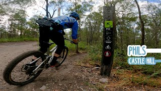
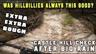
Short technical trail, featuring loose off camber corners, small gap jumps, loose trail surface and steep sections

Access Info

Main entry to the trail area is from Mary Street Scout Hall, all main trails start from the top of the hill.

Local Trail Association
Traditionally Indigenous Territory

Recent Activity on Trail

Past Week
  • 2 rides
  • 6 miles average
6 Months
  • 54 rides
  • 10 miles avg distance
All
  • 528 rides
  • Last: Jun 21, 2026
c1c2c3c4
January
February
March
April
May
June
July
August
September
October
November
December
update trails status or condition

Phils Trail Reports

statusdatedescription
Mar 15, 2026 @ 7:40am (Australia/Brisbane)
Mar 14, 2026
Feb 23, 2026 @ 4:30pm (Australia/Brisbane)
Feb 22, 2026
Multiple Trees down Unridable at speed
Dec 23, 2025 @ 6:05pm (Australia/Brisbane)
Dec 23, 2025
Tree fallen across trail after the big right hand turn.
Mar 14, 2025 @ 11:53am
Mar 14, 2025
Big ruts after TC Alfred
Nov 25, 2023 @ 10:07pm
Nov 25, 2023
Running good after some rain.
more »
Status:
on Mar 15, 2026
Ideal
Avg: 4.11 (2 votes)
Your vote: 0

view (8,532)
close
3D
Trail Conditions
  • Unknown
  • Snow Groomed
  • Snow Packed
  • Snow Covered
  • Snow Cover Partial
  • Freeze/thaw Cycle
  • Icy
  • Prevalent Mud
  • Wet
  • Variable
  • Ideal
  • Dry
  • Very Dry
Trail Flow (Ridden Direction)
Trailforks scans users ridelogs to determine the most popular direction each trail is ridden. A good flowing trail network will have most trails flowing in a single direction according to their intension.
The colour categories are based on what percentage of riders are riding a trail in its intended direction.
  • > 96%
  • > 90%
  • > 80%
  • > 70%
  • > 50%
  • < 50%
  • bi-directional trail
  • no data
Trail Last Ridden
Trailforks scans ridelogs to determine the last time a trail was ridden.
  • < 2 days
  • < 1 week
  • < 2 weeks
  • < 1 month
  • < 6 months
  • > 6 months
Trail Ridden Direction
The intended direction a trail should be ridden.
  • Downhill Only
  • Downhill Primary
  • Both Directions
  • Uphill Primary
  • Uphill Only
  • One Direction
Contribute Details
Colors indicate trail is missing specified detail.
  • Description
  • Photos
  • Description & Photos
  • Videos
Trail Popularity ?
Trailforks scans ridelogs to determine which trails are ridden the most in the last 9 months. Trails are compared with nearby trails in the same city region with a possible 25 colour shades. Think of this as a heatmap, more rides = more kinetic energy = warmer colors.
  • most popular
  • popular
  • less popular
  • not popular
ATV/ORV/OHV Filter
Max Vehicle Width
inches
US Cell Coverage
Legend
cell carrier legend

Radar Time
Activity Recordings
Trailforks uses anonymized public activity data. ?
Activity Recordings
Trailforks uses anonymized public activity data. ?
Personal Heatmap
Activity Types
all / none
Options
2
Date range month
Winter Trails
Warning A routing network for winter maps does not exist. Selecting trails using the winter trails layer has been disabled.
Missing Trails
Most Popular
Least Popular
Trails are colored based on popularity. The more popular a trail is, the more red. Less popular trails trend towards green.
Jump Magnitude Heatmap
Heatmap of where riders jump on trails. Zoom in to see individual jumps, click circles to view jump details.
BC Backroad Status

Service Road Atlas is a free to use, community-driven service for viewing and creating reports on the numerous back-country service roads around B.C. and Alberta.

map legend
Slope Aspect
Direction the slope faces
Flat N NE E SE S SW W NW
Trails Deemphasized
Trails are shown in grey.
disable
Only show trails with no bike usage.
Enable
Suggested Layers
Based on selected activity type

    Save the current map location and zoom level as your default home location whenever this page is loaded.

    Save
        Directions to phils trailhead (-27.632630, 152.801230)

        Photos

        2 more »
        72 |
        Nov 12, 2019 @ 4:48pm
        Nov 12, 2019
        108 |
        Nov 12, 2019 @ 4:48pm
        Nov 12, 2019

        Videos

        7 more »
        youtuber Phils, Castle Hill - 3rd Person POV
        0:20 | 595 | Feb 6, 2021 , Ipswich
        Castle Hill Phils trail
        2:07 | 58 | Dec 6, 2024 , Ipswich
        RAW PHILS
        2:11 | 146 | Mar 15, 2024 , Ipswich
        youtuber Riding Castle Hill after all the big rain!...
        9:50 | 236 | Mar 21, 2022 , Ipswich

        Routes with this trail

        5.0 13 miles 1,948 ft 143 Loop
        Every singletrack on the hill linked up into one mega ride.
        3 miles 538 ft 41
        potential race course for future events

        Reviews / Comments

        No reviews yet, be the first to write a review or ask a question.
        Use trail reports to comment on trail conditions.


        We hope you've been enjoying Trailforks!

        Create a FREE account to view trail comments and much more.

        • By micko1000 & contributors
        • #48749 - 3,098 views

        Frequently Asked Questions About Phils

        Where is Phils located?
        Phils is located in Castle Hill, Ipswich, Australia. It is part of the Castle Hill trail network. The trailhead is located at coordinates -27.63263, 152.80123.
        How hard is Phils?
        Phils is rated as Black Diamond difficulty. The physical rating is Moderate. The average grade is 10.3%.
        What is the elevation gain for Phils?
        The trail has 217 ft of elevation descent. The elevation ranges from 115 ft to 331 ft.
        Is Phils a point to point trail?
        Phils is not a point to point trail. The direction is Downhill Primary. The trail type is singletrack.

        Hit the Trail

        Open in App

        Get this trail on your phone instantly.
        open trail in app

        Download Trail

        Save to wishlist, Garmin & download.
        save the trail

        Find Related Routes

        Find routes and users activities that include this trail.
        find routes for this trail

        You must enter a description before submitting.