2,556 ft
Distance
15 ft
Climb
-125 ft
Descent
00:02:41
Avg time
Supporters, Builders, Maintainers & Land Managers of Pilot Trail
- Sponsor
Pilot Trail Details
-
Activities
- Mountain Bike
- E-Bike
-
Riding AreaMt. Clarence
Albany -
Difficulty Rating
-
Voted DifficultyBlue (1 vote)
-
Trail TypeSingletrack
-
Bike TypeDH, AM, XC, Fat
-
DirectionDownhill OnlyPopular direction shown
-
Climb DifficultyGreen
-
Physical RatingModerate
-
Trail VisibilityAlways easy to follow
-
Family FriendlyYes
-
Dogs AllowedYes
-
eBike AllowedYes up to Class 1
-
TTFs on TrailBerm, Rock Garden
-
Ride in RainYes
-
Global Ranking
-
Local Popularity100 in Mountain Biking [+]
- 75 in E-Biking
-
Year Opened2017
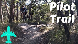
This is the first of hopefully many new mtb trails as part of the trails hub.
This is a great trail, with features that will keep all riders happy. It starts from the trail hub at the Apex Drive carpark and winds it's way down to the carpark at the base of Apex Drive. It is separated into 3 sections by fire trail crossovers. Please be aware of other trail users when crossing the fire trails
Access Info
Access from the Apex Lookout carpark. Follow trail markers.
Traditionally Indigenous Territory
More Stats for Pilot Trail mountain bike trail trail
-
Altitude change-110 ft
-
Altitude min265 ft
-
Altitude max384 ft
-
Altitude start384 ft
-
Altitude end274 ft
-
Grade-4.3%
-
Grade max-17.132%
-
Grade min9.274%
-
Distance climb332 ft
-
Distance down1,527 ft
-
Distance flat697 ft
-
Avg time00:02:41
-
Avg reverse time00:03:10
- view trail stats
close
Trail Conditions
- Unknown
- Snow Groomed
- Snow Packed
- Snow Covered
- Snow Cover Inadequate
- Freeze/thaw Cycle
- Icy
- Prevalent Mud
- Wet
- Variable
- Ideal
- Dry
- Very Dry
Trail Flow (Ridden Direction)
Trailforks scans users ridelogs to determine the most popular direction each trail is ridden. A good flowing trail network will have most trails flowing in a single direction according to their intension.
The colour categories are based on what percentage of riders are riding a trail in its intended direction.
- > 96%
- > 90%
- > 80%
- > 70%
- > 50%
- < 50%
- bi-directional trail
- no data
Trail Last Ridden
Trailforks scans ridelogs to determine the last time a trail was ridden.
- < 2 days
- < 1 week
- < 2 weeks
- < 1 month
- < 6 months
- > 6 months
Trail Ridden Direction
The intended direction a trail should be ridden.
- Downhill Only
- Downhill Primary
- Both Directions
- Uphill Primary
- Uphill Only
- One Direction
Contribute Details
Colors indicate trail is missing specified detail.
- Description
- Photos
- Description & Photos
- Videos
Trail Popularity ?
Trailforks scans ridelogs to determine which trails are ridden the most in the last 9 months.
Trails are compared with nearby trails in the same city region with a possible 25 colour shades.
Think of this as a heatmap, more rides = more kinetic energy = warmer colors.
- most popular
- popular
- less popular
- not popular
ATV/ORV/OHV Filter
Max Vehicle Width
inches
Radar Time
x
Activity Recordings
Trailforks users anonymized public ridelogs from the past 6 months.
- mountain biking recent
- mountain biking (>6 month)
- hiking (1 year)
- moto (1 year)
Activity Recordings
Trailforks users anonymized public skilogs from the past 12 months.
- Downhill Ski
- Backcountry Ski
- Nordic Ski
Jump Magnitude Heatmap
Heatmap of where riders jump on trails. Zoom in to see individual jumps, click circles to view jump details.
Trails Deemphasized
Trails are shown in grey.
Only show trails with NO bikes.
Save the current map location and zoom level as your default home location whenever this page is loaded.
Save
Directions to pilot-trail trailhead
(-35.026246, 117.902064)
update trails status or condition
Pilot Trail Trail Reports
view all reports »
Recent Ridelog Activity on Trail
Past Week
- 2 rides
- 5 miles avg distance
6 Months
- 144 rides
- 7 miles avg distance
All
- 1,529 rides
Photos
more »
Routes with this trail
-
+ 1

Really awesome trail. Lots of rocks and loose stuff.
[Reply]
Brake
(Dec 25, 2020 at 22:16)

Riding well. Dry but coping with it well. A bit cut up through the tight berms.
[Reply]
Videos
more »
Nearby Trails
- Albany Downhill 1,194 ft
- Water Tank 1,227 ft
- Pipeline Track 1,289 ft
- Downup 1,647 ft
- The Dirty Bush 3,435 ft
- embed Pilot Trail trail on your website
- By MichaelWhiteWhitey & contributors
- #100026 - 3,821 views
- subscribe
- login to download gpx or kml files.