3,228 ft
Distance
86 ft
Climb
00:05:55
Avg time

Pine Beetle Details

  • Activities
    • Mountain Bike
    • Hike
    • Trail Running
  • Riding Area
    Tallahassee
    , Florida
  • AKA
    Kohl's
  • Difficulty Rating
  • Hiking SAC Scale
    T1 Hiking
  • Trail Type
    Singletrack
  • Bike Type
    DH, AM
  • Direction
    Both Directions
  • Climb Difficulty
    Blue
  • Physical Rating
    Hard
  • Dogs Allowed
    Yes
  • eBike Allowed
  • TTFs on Trail
    Bridge, Jump, Gap Jump, Log Ride
  • Global Ranking
    #54771 in Mountain Biking
  • Local Popularity
    70 in Mountain Biking [+]
    • 5 in Trail Running
    • 5 in Hiking
  • Land Owner

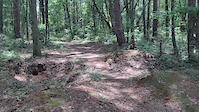
This is probably one of the funnest downhill sections of trail in Tallahassee. The entrance to the trail is rather steep and rooty so be prepared to pick a good line. There are a few trail features to watch out for. There are a couple of log roll overs that can be used as jumps with the right speed. There are also two relatively big jumps on the trail one of them is a high speed gap jump about 8ft long and the other one is not a gap but not easily rollable and is probably about 10ft long (both meant to be hit at high speeds. The rest of the trail flows nicely with one creek crossing that has a bridge over it. This trail ends on Park Ave across the street from a Publix supermarket. Go across the street and continue up Blairstone Rd toward the overpass. Before getting on the overpass on the right you will see a trail that continues to the next trail section called Fern trail. Fern trail takes you all the way to Tom Brown park completely off road where you will find another trail system with about 15 miles of awesome singletrack. The climb back up is somewhat brutal especially at the very end.

Local Trail Association
Traditionally Indigenous Territory
More Stats for Pine Beetle mountain bike trail trail
  • Altitude change
    86 ft
  • Altitude min
    85 ft
  • Altitude max
    172 ft
  • Altitude start
    86 ft
  • Altitude end
    171 ft
  • Grade
    2.7%
  • Grade max
    -0.9%
  • Grade min
    15.6%
  • Distance climb
    2,726 ft
  • Distance down
    72 ft
  • Distance flat
    430 ft
  • Avg time
    00:05:55
  • Avg reverse time
    00:04:39
  • view trail stats
Status:
on Mar 28, 2022
Ideal
Avg: 4.35 (3 votes)
Your vote: 0

view (513)
close
3D
Trail Conditions
  • Unknown
  • Snow Groomed
  • Snow Packed
  • Snow Covered
  • Snow Cover Inadequate
  • Freeze/thaw Cycle
  • Icy
  • Prevalent Mud
  • Wet
  • Variable
  • Ideal
  • Dry
  • Very Dry
Trail Flow (Ridden Direction)
Trailforks scans users ridelogs to determine the most popular direction each trail is ridden. A good flowing trail network will have most trails flowing in a single direction according to their intension.
The colour categories are based on what percentage of riders are riding a trail in its intended direction.
  • > 96%
  • > 90%
  • > 80%
  • > 70%
  • > 50%
  • < 50%
  • bi-directional trail
  • no data
Trail Last Ridden
Trailforks scans ridelogs to determine the last time a trail was ridden.
  • < 2 days
  • < 1 week
  • < 2 weeks
  • < 1 month
  • < 6 months
  • > 6 months
Trail Ridden Direction
The intended direction a trail should be ridden.
  • Downhill Only
  • Downhill Primary
  • Both Directions
  • Uphill Primary
  • Uphill Only
  • One Direction
Contribute Details
Colors indicate trail is missing specified detail.
  • Description
  • Photos
  • Description & Photos
  • Videos
Trail Popularity ?
Trailforks scans ridelogs to determine which trails are ridden the most in the last 9 months. Trails are compared with nearby trails in the same city region with a possible 25 colour shades. Think of this as a heatmap, more rides = more kinetic energy = warmer colors.
  • most popular
  • popular
  • less popular
  • not popular
ATV/ORV/OHV Filter
Max Vehicle Width
inches

Radar Time
x Activity Recordings
Trailforks users anonymized public ridelogs from the past 6 months.
  • mountain biking recent
  • mountain biking (>6 month)
  • hiking (1 year)
  • moto (1 year)
Activity Recordings
Trailforks users anonymized public skilogs from the past 12 months.
  • Downhill Ski
  • Backcountry Ski
  • Nordic Ski
  • Snowmobile
Jump Magnitude Heatmap
Heatmap of where riders jump on trails. Zoom in to see individual jumps, click circles to view jump details.
Trails Deemphasized
Trails are shown in grey.
disable
Only show trails with NO bikes.
enable

Save the current map location and zoom level as your default home location whenever this page is loaded.

Save
      Directions to pine-beetle trailhead (30.441550, -84.248330)
      update trails status or condition

      Pine Beetle Trail Reports

      statusdatedescription
      Mar 28, 2022 @ 10:36am
      Mar 28, 2022
      Occupied homeless camp a few feet off the trail. Trash everywhere. Smelled gnarly. Otherwise good.
      Feb 14, 2022 @ 1:11pm
      Feb 14, 2022
      Excellent conditions. Signs of homelessness. Super fun spot.
      view all reports »

      Recent Ridelog Activity on Trail

      Past Week
      • 0 rides
      •  
      6 Months
      • 22 rides
      • 29 miles avg distance
      All
      • 409 rides
      • Last: Mar 12, 2023

      Photos

      more »
      141 |
      Mar 13, 2018 @ 8:07am
      Mar 13, 2018

      Routes with this trail

      titledistance
      Kohl's Ride14 miles

      Reviews / Comments

      No reviews yet, be the first to write a review or ask a question.
      Use trail reports to comment on trail conditions.


      Login or Sign Up to Comment

      Videos

      more »
      Kohls Gap Jump
      62 | Aug 21, 2021 , Tallahassee
      • subscribe
      • flag
      • login to download gpx or kml files.