more stats
3,458 ft
Distance
-498 ft
Descent
00:08:44
Avg time
-498 ft
Altitude change
2,689 ft
Altitude min
3,187 ft
Altitude max
3,187 ft
Altitude start
2,690 ft
Altitude end
-14.4%
Grade
-74.6%
Grade max
-0.5%
Grade min
3,458 ft
Distance down
00:08:44
Avg time

Polom Details

  • Activities
    • Hike
    • Mountain Bike
    • Trail Running
  • Riding Area
    Polom
    Žilina
  • AKA
    Modrá z Polomu
  • Difficulty Rating
  • Local Popularity
    60 in Mountain Biking [+]
    • 60 in Trail Running
    • 80 in Hiking
  • Global Ranking
    #49431 in Mountain Biking [+]
    • #82561 in Trail Running
    • #50741 in Hiking
  • Hiking SAC Scale
    T1 Hiking
  • Blaze Color
  • Trail Type
    Mixed
  • Bike Type
    DH, AM, XC
  • Direction
    Downhill Primary
    Popular Direction Shown
  • Climb Difficulty
    Green
  • Physical Rating
    Hard
  • Trail Visibility
    Always easy to follow
  • Dogs Allowed
    Yes
  • TTFs on Trail
    Rock Garden
  • OSM Way

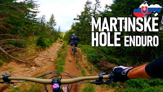
Modrá TZ z Polomu na sedlo Kojšová. Trail začína ako hladká vrstevnica s pár koreňmi. Po zhruba 200 metroch naberá technickejší charakter vďaka množstvu kameňov a koreňov. Po cca 500 metroch sa trail točí doprava, nasleduje dlhší padák so sklonom do 45% V najprušom mieste je nutné dropnúť padnutý strom, niekedy tu bývajú aj voľné kamene. Následne sa sklon zvoľní, chodník chvíľu pokračuje ako singletrail. Po odbočke doľava pokračuje chodník zvážnicou takmer až na sedlo Kojšová. V zjazde je studnička s pitnou vodou.

Blue hiking trail From "Polom" to "sedlo Kojšová". It starts as a singletrail with some rocks and roots. Followed by steep chute (-45%) with loose rocks and a small drop. Trail ends as a double track. There's also water source in the downhill part of doubletrack.

This trail is unsanctioned.

Recent Activity on Trail

Past Week
  • 0 rides
  •  
6 Months
  • 3 rides
  • 19 miles avg distance
All
  • 48 rides
  • Last: Jun 24, 2026
c1c2c3c4
January
February
March
April
May
June
July
August
September
October
November
December
update trails status or condition

Polom Trail Reports

statusdatedescription
Feb 15, 2026 @ 6:06am (Europe/Bratislava)
Feb 14, 2026
Nov 23, 2025 @ 6:03am (Europe/Bratislava)
Nov 22, 2025
Oct 25, 2025 @ 12:46pm (Europe/Bratislava)
Oct 25, 2025
málinko vlhké, v strminke viac lístia, tak opatrne
Sep 14, 2025 @ 6:02am (Europe/Bratislava)
Sep 13, 2025
Aug 13, 2025 @ 4:20pm
Aug 13, 2025
nájazd na pešo medzi haldami dreva, traverz top, strmina už brutál sypanica
more »
Status:
on Feb 15, 2026
Snow Covered
Avg: 4.55 (14 votes)
Your vote: 0

view (584)
close
3D
Trail Conditions
  • Unknown
  • Snow Groomed
  • Snow Packed
  • Snow Covered
  • Snow Cover Partial
  • Freeze/thaw Cycle
  • Icy
  • Prevalent Mud
  • Wet
  • Variable
  • Ideal
  • Dry
  • Very Dry
Trail Flow (Ridden Direction)
Trailforks scans users ridelogs to determine the most popular direction each trail is ridden. A good flowing trail network will have most trails flowing in a single direction according to their intension.
The colour categories are based on what percentage of riders are riding a trail in its intended direction.
  • > 96%
  • > 90%
  • > 80%
  • > 70%
  • > 50%
  • < 50%
  • bi-directional trail
  • no data
Trail Last Ridden
Trailforks scans ridelogs to determine the last time a trail was ridden.
  • < 2 days
  • < 1 week
  • < 2 weeks
  • < 1 month
  • < 6 months
  • > 6 months
Trail Ridden Direction
The intended direction a trail should be ridden.
  • Downhill Only
  • Downhill Primary
  • Both Directions
  • Uphill Primary
  • Uphill Only
  • One Direction
Contribute Details
Colors indicate trail is missing specified detail.
  • Description
  • Photos
  • Description & Photos
  • Videos
Trail Popularity ?
Trailforks scans ridelogs to determine which trails are ridden the most in the last 9 months. Trails are compared with nearby trails in the same city region with a possible 25 colour shades. Think of this as a heatmap, more rides = more kinetic energy = warmer colors.
  • most popular
  • popular
  • less popular
  • not popular
ATV/ORV/OHV Filter
Max Vehicle Width
inches
US Cell Coverage
Legend
cell carrier legend

Radar Time
Activity Recordings
Trailforks uses anonymized public activity data. ?
Activity Recordings
Trailforks uses anonymized public activity data. ?
Personal Heatmap
Activity Types
all / none
Options
2
Date range month
Winter Trails
Warning A routing network for winter maps does not exist. Selecting trails using the winter trails layer has been disabled.
Missing Trails
Most Popular
Least Popular
Trails are colored based on popularity. The more popular a trail is, the more red. Less popular trails trend towards green.
Jump Magnitude Heatmap
Heatmap of where riders jump on trails. Zoom in to see individual jumps, click circles to view jump details.
BC Backroad Status

Service Road Atlas is a free to use, community-driven service for viewing and creating reports on the numerous back-country service roads around B.C. and Alberta.

map legend
Slope Aspect
Direction the slope faces
Flat N NE E SE S SW W NW
Trails Deemphasized
Trails are shown in grey.
disable
Only show trails with no bike usage.
Enable
Suggested Layers
Based on selected activity type

    Save the current map location and zoom level as your default home location whenever this page is loaded.

    Save
        Directions to polom trailhead (49.150670, 18.843620)

        Photos

        10 more »
        360 |
        May 23, 2019 @ 7:08am
        May 23, 2019
        414 |
        May 23, 2019 @ 7:09am
        May 23, 2019
        380 |
        Mar 16, 2016 @ 5:57am
        Mar 16, 2016
        300 |
        Mar 16, 2016 @ 5:56am
        Mar 16, 2016

        Videos

        3 more »
        Enduro Martinské Hole - SK | SEASON 2k21 e03
        17:19 | 342 | Jun 22, 2021 , Žilina
        Poď ty satan! Hole, Minčol, Strečno
        13:25 | 562 | Aug 29, 2019 , Žilina
        Polom Crash
        0:07 | 826 | May 20, 2015 , Žilina

        Routes with this trail

        5.0 13 miles 3,130 ft 8 Point to Point
        AM/EN route from Turie to Strecno.
        3.0 31 miles 7,992 ft 31 Loop
        Ride plan - we'll see how it goes

        2 Reviews & Comments


        We hope you've been enjoying Trailforks!

        Create a FREE account to view trail comments and much more.

        Nearby Trails

        • #50335 - 5,287 views

        Frequently Asked Questions About Polom

        Where is Polom located?
        Polom is located in Polom, Žilina, Slovakia. It is part of the Polom trail network. The trailhead is located at coordinates 49.15067, 18.84362.
        How hard is Polom?
        Polom is rated as Double Black Diamond difficulty. The physical rating is Hard. The average grade is 14.4%. The climb difficulty is rated Green.
        What is the elevation gain for Polom?
        The trail has 152 m of elevation descent. The elevation ranges from 820 m to 971 m.
        Is Polom a point to point trail?
        Polom is not a point to point trail. The direction is Downhill Primary. The trail type is mixed.

        Hit the Trail

        Open in App

        Get this trail on your phone instantly.
        open trail in app

        Download Trail

        Save to wishlist, Garmin & download.
        save the trail

        Find Related Routes

        Find routes and users activities that include this trail.
        find routes for this trail

        You must enter a description before submitting.