more stats
1,434 ft
Distance
8 ft
Climb
-135 ft
Descent
00:04:31
Avg time
-127 ft
Altitude change
233 ft
Altitude min
360 ft
Altitude max
360 ft
Altitude start
233 ft
Altitude end
-8.9%
Grade
-33.9%
Grade max
8.3%
Grade min
121 ft
Distance climb
1,240 ft
Distance down
75 ft
Distance flat
00:04:31
Avg time

Potongo Details

  • Activities
    • Mountain Bike
    • E-Bike
    • Hike
    • Trail Running
  • Riding Area
    Artxanda
    Bilbao
  • Difficulty Rating
  • Voted Difficulty
    Black Diamond (1 vote)
  • Local Popularity
    70 in Mountain Biking [+]
    • 30 in E-Biking
    • 65 in Trail Running
    • 85 in Hiking
  • Global Ranking
    #60249 in Mountain Biking [+]
    • #99430 in E-Biking
    • #71908 in Trail Running
    • #50277 in Hiking
  • Trail Type
    Singletrack
  • Bike Type
    DH, AM
  • Direction
    Downhill Only
    Popular Direction Shown
  • Dogs Allowed
    Yes
  • eBike Allowed
    Yes up to Class 1
  • TTFs on Trail
    Berm, Drop, Jump, Gap Jump, Rock Garden

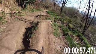
Inicio con peraltes y saltos dobles, luego unos saltos mas pequeños y juguetones. Cruzamos una pista por la que van peatones y comienza la segunda parte, sendero con resaltes, minisaltos naturales, alguna curva y final en una carretera asfaltada. La bajada es disfrutona, si te pilla cerca esto es lo que hay. Enjoy it!!!

Recent Activity on Trail

Past Week
  • 1 rides
  • 4 miles average
6 Months
  • 12 rides
  • 13 miles avg distance
All
  • 47 rides
  • Last: Jun 3, 2026
c1c2c3c4
January
February
March
April
May
June
July
August
September
October
November
December
update trails status or condition

Potongo Trail Reports

statusdatedescription
May 22, 2026 @ 9:48pm (Europe/Madrid)
May 22, 2026
Bien pero un par de roderas que ojo
May 9, 2026 @ 10:03am (Europe/Madrid)
May 9, 2026
May 3, 2026 @ 9:03am (Europe/Madrid)
May 3, 2026
May 1, 2026 @ 8:55pm (Europe/Madrid)
May 1, 2026
Algún charco y alguna zona embarrada pero bien
Apr 19, 2026 @ 11:42pm (Europe/Madrid)
Apr 19, 2026
pista perfecta menos la bajada inclinada hya un árbol abajo
more »
Status:
on May 22, 2026
Avg: 4.08 (6 votes)
Your vote: 0

view (195)
close
3D
Trail Conditions
  • Unknown
  • Snow Groomed
  • Snow Packed
  • Snow Covered
  • Snow Cover Partial
  • Freeze/thaw Cycle
  • Icy
  • Prevalent Mud
  • Wet
  • Variable
  • Ideal
  • Dry
  • Very Dry
Trail Flow (Ridden Direction)
Trailforks scans users ridelogs to determine the most popular direction each trail is ridden. A good flowing trail network will have most trails flowing in a single direction according to their intension.
The colour categories are based on what percentage of riders are riding a trail in its intended direction.
  • > 96%
  • > 90%
  • > 80%
  • > 70%
  • > 50%
  • < 50%
  • bi-directional trail
  • no data
Trail Last Ridden
Trailforks scans ridelogs to determine the last time a trail was ridden.
  • < 2 days
  • < 1 week
  • < 2 weeks
  • < 1 month
  • < 6 months
  • > 6 months
Trail Ridden Direction
The intended direction a trail should be ridden.
  • Downhill Only
  • Downhill Primary
  • Both Directions
  • Uphill Primary
  • Uphill Only
  • One Direction
Contribute Details
Colors indicate trail is missing specified detail.
  • Description
  • Photos
  • Description & Photos
  • Videos
Trail Popularity ?
Trailforks scans ridelogs to determine which trails are ridden the most in the last 9 months. Trails are compared with nearby trails in the same city region with a possible 25 colour shades. Think of this as a heatmap, more rides = more kinetic energy = warmer colors.
  • most popular
  • popular
  • less popular
  • not popular
ATV/ORV/OHV Filter
Max Vehicle Width
inches
US Cell Coverage
Legend
cell carrier legend

Radar Time
Activity Recordings
Trailforks uses anonymized public activity data. ?
Activity Recordings
Trailforks uses anonymized public activity data. ?
Personal Heatmap
Activity Types
all / none
Options
2
Date range month
Winter Trails
Warning A routing network for winter maps does not exist. Selecting trails using the winter trails layer has been disabled.
Missing Trails
Most Popular
Least Popular
Trails are colored based on popularity. The more popular a trail is, the more red. Less popular trails trend towards green.
Jump Magnitude Heatmap
Heatmap of where riders jump on trails. Zoom in to see individual jumps, click circles to view jump details.
BC Backroad Status

Service Road Atlas is a free to use, community-driven service for viewing and creating reports on the numerous back-country service roads around B.C. and Alberta.

map legend
Slope Aspect
Direction the slope faces
Flat N NE E SE S SW W NW
Trails Deemphasized
Trails are shown in grey.
disable
Only show trails with no bike usage.
Enable
Suggested Layers
Based on selected activity type

    Save the current map location and zoom level as your default home location whenever this page is loaded.

    Save
        Directions to potongo trailhead (43.275850, -2.937760)

        Photos

        7 more »
        62 |
        Apr 3, 2025 @ 10:14am
        Apr 3, 2025
        65 |
        Apr 3, 2025 @ 10:14am
        Apr 3, 2025
        119 |
        Sep 18, 2022 @ 3:12pm
        Sep 18, 2022
        152 |
        May 24, 2022 @ 6:43am
        May 24, 2022

        Videos

        5 more »
        Potongo Bilbao
        3:16 | 1383 | Sep 2, 2019 , Bilbao
        Dh Potongo 2018
        2:39 | 652 | Sep 2, 2019 , Bilbao
        0:18 | 151 | Sep 24, 2022 , Bilbao
        POTONGO(artxanda)
        0:48 | | Sep 18, 2022 , Bilbao

        11 Reviews & Comments


        We hope you've been enjoying Trailforks!

        Create a FREE account to view trail comments and much more.

        • By zab80TF Pro & contributors
        • #172163 - 2,714 views

        Frequently Asked Questions About Potongo

        Where is Potongo located?
        Potongo is located in Artxanda, Bilbao, Spain. It is part of the Artxanda trail network. The trailhead is located at coordinates 43.27585, -2.93776.
        How hard is Potongo?
        Potongo is rated as Red difficulty. The average grade is 8.9%.
        What is the elevation gain for Potongo?
        Potongo has 8 ft of elevation gain. The trail has 135 ft of elevation descent. The elevation ranges from 233 ft to 360 ft.
        Is Potongo a point to point trail?
        Yes, Potongo is a point to point trail. The direction is Downhill Only. The trail type is singletrack.

        Hit the Trail

        Open in App

        Get this trail on your phone instantly.
        open trail in app

        Download Trail

        Save to wishlist, Garmin & download.
        save the trail

        Find Related Routes

        Find routes and users activities that include this trail.
        find routes for this trail

        You must enter a description before submitting.