
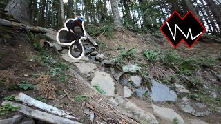


 Rock Face
 Rock Garden
Open in App
Get this trail on your phone instantly.

MOUNTAIN BIKING ONLY
Tiger's new downhill-only, bike-specific trail- almost 2 miles of high-speed descending goodness. A very fun trail The double black diamond rating is area appropriate, and meant to be a "squirrel catcher" keeping away those not ready. In reality, however, difficulty is closer to a hard single Black Diamond Squamish, BC or Bellingham-area trail.
Due to the 3.5mi, ~2,000 foot vertical road climb to the trailhead near the top of East Tiger Mtn, an all-mountain bike with ~150mm of travel is preferred. The trail is still fun (and significantly easier) on a DH bike, but the climb limits this to rare shuttle day events, or a long push. Most riders seem to choose a half lid on Predator, but full faces are common too.
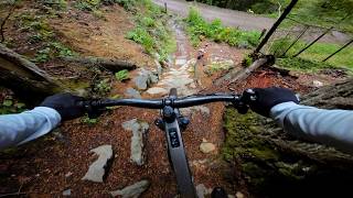
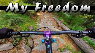
This long trail has it all: fast, flowy, bermy sections, combined with a lot of PNW tech & gnar. Expect moderate steepness, small- medium drops, rollable doubles and tables, descending rock gardens, rocks, roots, and even a few "root gardens" (a whole buncha roots). In the wet, the off-camber root gardens significantly increase the difficulty factor - beware. The two rock gardens onto and off the climbing road that divides the upper and lower sections look intimidating, but are not as tough as they look. They roll quite well. For your first time, just be smooth and light on the bike, enter slow, and don't grab the brakes hard until tires are on a flat section.
From the parking lots, climb the new Master Link and Quick Link climbing-specific trails. Exit Quick Link and continue up the Crossover Road until the entrance to Predator on your left.
Alternatively, take the East Tiger Summit road up toward the summit. All Tiger trails are well signed. At the first T intersection, continue Right up toward the summit. At the next T intersection, don't go Left up the final summit climb, and instead continue to the Right onto the Crossover road. The trailhead to Predator is on your right a few hundred feet up the road. From the trailhead, the trail climbs for a few hundred more feet before the descent begins. Predator can also be accessed from the other Tiger trails by climbing up the Crossover road.
NO Hiking or Equestrians allowed!
| c1 | c2 | c3 | c4 |
|---|---|---|---|
January | February | March | April |
May | June | July | August |
September | October | November | December |

Service Road Atlas is a free to use, community-driven service for viewing and creating reports on the numerous back-country service roads around B.C. and Alberta.
Save the current map location and zoom level as your default home location whenever this page is loaded.
SaveWe hope you've been enjoying Trailforks!
Create a FREE account to view trail comments and much more.
You must enter a description before submitting.

