more stats
2,241 ft
Distance
-421 ft
Descent
00:05:25
Avg time
-421 ft
Altitude change
895 ft
Altitude min
1,316 ft
Altitude max
1,316 ft
Altitude start
896 ft
Altitude end
-18.8%
Grade
-68.4%
Grade max
-2.7%
Grade min
2,241 ft
Distance down
00:05:25
Avg time

ProSpacker Details

  • Activities
    • Mountain Bike
    • E-Bike
  • Riding Area
    Traquair Trails
    Innerleithen
  • AKA
    pro spacker
  • Difficulty Rating
  • Local Popularity
    40 in Mountain Biking [+]
    • 45 in E-Biking
  • Global Ranking
    #78993 in Mountain Biking [+]
    • #63852 in E-Biking
  • Trail Type
    Singletrack
  • Bike Type
    DH, AM
  • Direction
    Downhill Only
    Popular Direction Shown
  • Physical Rating
    Extreme
  • Dogs Allowed
    Yes
  • eBike Allowed
    Yes up to Class 1

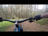
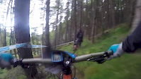
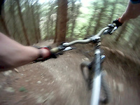
Made a lot easier for the 2014 EWS stage, the best bit is very steep, loose and twisty. It's got everything, crossing a little stream a couple of times at the bottom.

Access Info

Following the red XC route, from the top of "Clattering Path", turn right along the fire road. Entrance is a couple of hundred yards along. Start is not that steep, across furrows.

This trail is unsanctioned.

Recent Activity on Trail

Past Week
  • 0 rides
  •  
6 Months
  • 0 rides
  •  
All
  • 9 rides
  • Last: Jun 14, 2026
c1c2c3c4
January
February
March
April
May
June
July
August
September
October
November
December
update trails status or condition

ProSpacker Trail Reports

statusdatedescription
Oct 8, 2025 @ 10:37pm (Europe/London)
Oct 8, 2025
Clear, other than minor branch debris.
Mar 21, 2024 @ 4:20am
Mar 21, 2024
running good, trees been cleared
Jun 8, 2023 @ 6:22am
Jun 8, 2023
reporter Tree almost fallen across the track in the lower part. Going to be an issue if you arrive at it going quick.
Apr 18, 2023 @ 1:13pm
Apr 18, 2023
Tree across trail at head height in lower third steep and fast section. Can get under it but prime height to clothes line you.
Mar 22, 2023 @ 2:08am
Mar 22, 2023
Trail running great via Bit Of Spacker entrance. Saw no major issues.
more »
Status:
on Oct 8, 2025
Avg: 4.47 (13 votes)
Your vote: 0

view (592)
close
3D
Trail Conditions
  • Unknown
  • Snow Groomed
  • Snow Packed
  • Snow Covered
  • Snow Cover Partial
  • Freeze/thaw Cycle
  • Icy
  • Prevalent Mud
  • Wet
  • Variable
  • Ideal
  • Dry
  • Very Dry
Trail Flow (Ridden Direction)
Trailforks scans users ridelogs to determine the most popular direction each trail is ridden. A good flowing trail network will have most trails flowing in a single direction according to their intension.
The colour categories are based on what percentage of riders are riding a trail in its intended direction.
  • > 96%
  • > 90%
  • > 80%
  • > 70%
  • > 50%
  • < 50%
  • bi-directional trail
  • no data
Trail Last Ridden
Trailforks scans ridelogs to determine the last time a trail was ridden.
  • < 2 days
  • < 1 week
  • < 2 weeks
  • < 1 month
  • < 6 months
  • > 6 months
Trail Ridden Direction
The intended direction a trail should be ridden.
  • Downhill Only
  • Downhill Primary
  • Both Directions
  • Uphill Primary
  • Uphill Only
  • One Direction
Contribute Details
Colors indicate trail is missing specified detail.
  • Description
  • Photos
  • Description & Photos
  • Videos
Trail Popularity ?
Trailforks scans ridelogs to determine which trails are ridden the most in the last 9 months. Trails are compared with nearby trails in the same city region with a possible 25 colour shades. Think of this as a heatmap, more rides = more kinetic energy = warmer colors.
  • most popular
  • popular
  • less popular
  • not popular
ATV/ORV/OHV Filter
Max Vehicle Width
inches
US Cell Coverage
Legend
cell carrier legend

Radar Time
Activity Recordings
Trailforks uses anonymized public activity data. ?
Activity Recordings
Trailforks uses anonymized public activity data. ?
Personal Heatmap
Activity Types
all / none
Options
2
Date range month
Winter Trails
Warning A routing network for winter maps does not exist. Selecting trails using the winter trails layer has been disabled.
Missing Trails
Most Popular
Least Popular
Trails are colored based on popularity. The more popular a trail is, the more red. Less popular trails trend towards green.
Jump Magnitude Heatmap
Heatmap of where riders jump on trails. Zoom in to see individual jumps, click circles to view jump details.
BC Backroad Status

Service Road Atlas is a free to use, community-driven service for viewing and creating reports on the numerous back-country service roads around B.C. and Alberta.

map legend
Slope Aspect
Direction the slope faces
Flat N NE E SE S SW W NW
Trails Deemphasized
Trails are shown in grey.
disable
Only show trails with no bike usage.
Enable
Suggested Layers
Based on selected activity type

    Save the current map location and zoom level as your default home location whenever this page is loaded.

    Save
        Directions to prospacker trailhead (55.589230, -3.033010)

        Photos

        1 more »
        34 |
        Jun 8, 2023 @ 6:27am
        Jun 8, 2023

        Videos

        4 more »
        Prospacker - Night Riding Innerleithen's...
        716 | Jul 17, 2015 , Innerleithen
        Prospaker
        2:35 | 571 | Jul 31, 2017 , Innerleithen
        PreProSpacker Tweedlove International
        5:05 | 330 | May 19, 2016 , Innerleithen
        inners enduro
        3:02 | 526 | Jul 27, 2013 , Innerleithen

        Routes with this trail

        5.0 39 miles 9,224 ft 41 Loop Race
        Route of the Tweed Valley round of the 2022 E-Enduro World Series. Thursday 3rd June 2022 NYNY 1km -230m...

        Reviews / Comments

        No reviews yet, be the first to write a review or ask a question.
        Use trail reports to comment on trail conditions.


        We hope you've been enjoying Trailforks!

        Create a FREE account to view trail comments and much more.

        • #17977 - 3,455 views

        Frequently Asked Questions About ProSpacker

        Where is ProSpacker located?
        ProSpacker is located in Traquair Trails, Innerleithen, United Kingdom. It is part of the Traquair Trails trail network. The trailhead is located at coordinates 55.58923, -3.03301.
        How hard is ProSpacker?
        ProSpacker is rated as Black difficulty. The physical rating is Extreme. The average grade is 18.8%.
        What is the elevation gain for ProSpacker?
        The trail has 128 m of elevation descent. The elevation ranges from 273 m to 401 m.
        Is ProSpacker a point to point trail?
        Yes, ProSpacker is a point to point trail. The direction is Downhill Only. The trail type is singletrack.

        Hit the Trail

        Open in App

        Get this trail on your phone instantly.
        open trail in app

        Download Trail

        Save to wishlist, Garmin & download.
        save the trail

        Find Related Routes

        Find routes and users activities that include this trail.
        find routes for this trail

        You must enter a description before submitting.